
Heavy Rain, Flooding, and Chance of Severe Weather Staring Down the Southern U.S.
January 22, 2024
Posted: June 8, 2022 11:53 am


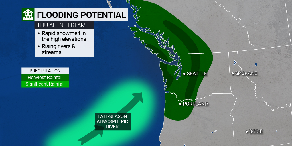
After enjoying a few days of dry conditions, an atmospheric river is setting up to bring heavy rain to the Pacific Northwest and up through British Columbia, Canada. The amount of forecast rain could trigger flash flooding.
It was an especially rainy May in western Washington, including the Seattle area. Some areas measured two to three times more than the normal amount of rainfall during this month. In fact, the bulk of this region has also already hit the average total rainfall for June just one week into the sixth month of the year.
Although storms that take root in the northern Pacific Ocean do not typically move into this corner of the U.S. and Canada this time of the year, this rain is forecast to move into the region later in the week. The atmospheric river could potentially create a fire hose effect that produces substantial precipitation.
Areas most at risk include those located within the same swath of land that was hit by last November’s atmospheric river. This epic rainstorm caused billions of dollars of damage to parts of British Columbia, Washington, and Oregon.
Although this type of rain is not unusual for the Pacific Northwest, it is the timing of the storms that has residents checking their calendars. In a typical year, the rainy period begins to wrap up in May with the dry season stretching into September. During this time period, rainfall is more sporadic and less widespread.
However, the city of Seattle measured 3.82 inches of rain in May. This amount was far above the average of 1.88 inches for the month. The Emerald City saw slightly over one inch of rainfall during the first six days of June. The city typically measures 1.45 inches for the entire month, putting it well ahead of schedule.
Vancouver, British Columbia has also been at the mercy of persistent rain with 3.45 inches falling in May and 1.15 inches coming down over the first six days of June.
The good news is that the abnormally wet spring may translate to a cooler summer. Last year’s dry spring led the way for the persistent heat that gripped the region. Because the ground is now saturated, the temperatures are not likely to soar as high.
However, the increase in rain during this time of the year could also cause the existing snowpack in the higher terrains to melt more quickly. This could trigger a rapid snowmelt runoff and flash flooding.
A parade of powerful storms is setting to deliver a plume of moisture to the southwestern corner of British Columbia and western Washington starting late Thursday. This area of moisture is currently stretching over thousands of miles from the ocean waters off the coast of Asia to the south of the Aleutian Islands in Alaska.
The rain is forecast to come in waves through the weekend. However, it is the first wave at the end of the work week that is most worrisome to weather experts because it could trigger the rapid snowmelt that often leads to flooding. Forecasters are calling for about 1 – 2 inches of rain near the coastal areas with 2 – 4 inches falling over the western-facing slopes of the Cascade Mountains. Although this amount of rain is generally not problematic, it could cause flooding if it hits the snowpack in a significant manner.
Warmer weather in the higher terrains as of late have brought the snowpack temperatures close to the freezing mark, making it ready to melt if hit by heavy rains. These conditions could translate to rainfall amounts that may thaw rapidly and have the effect of doubling or tripling the rainfall amounts.
This amount of snowmelt could lead to rapidly rising water with secondary roads and bridges washing out as a result. It is also possible that debris could block roadways in a flash flooding situation, making it important that motorists are aware of the surrounding area.
Another round of rain is forecast to hit the area Friday night and into Saturday. While this storm is not forecast to be as powerful as Thursday’s initial weather maker, the rain may travel farther to the south than the first system. This could bring showers to some areas of Northern California on Saturday.
Unfortunately, this rain is not predicted to dip far enough to the south to provide significant relief to the most drought-stricken areas of California.
Sharing is caring. Did you find this content useful? Feel free to bookmark or to post to your timeline for reference later!

January 21, 2024

January 19, 2024

January 18, 2024
