
Heavy Rain, Flooding, and Chance of Severe Weather Staring Down the Southern U.S.
January 22, 2024
Posted: June 2, 2022 2:45 pm


First Named Storm of 2022 Hurricane Season on the Horizon
Right on time, forecasters are growing increasingly confident that the Atlantic basin may see its first named storm of the 2022 hurricane season. The official start to the season was on June 1, just as things were heating up in the Gulf of Mexico.
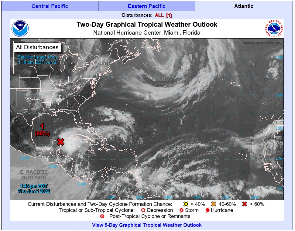
What was once Category 2 Hurricane Agatha has moved out of Mexico, leaving an area of circulation that came out from the Yucatan Peninsula and back into the northwestern Caribbean Sea on Tuesday. This area of circulation is beginning to pick up intensity as it moves through the warm ocean waters in its path.
The National Hurricane Center (NHC) designated this feature as Invest 91L on Wednesday. In its late Wednesday update, the NHC gave this system an 80% chance that it will strengthen into a tropical depression over the next 48 hours. While the track is still somewhat uncertain, the system would likely take aim at western Cuba and Florida on Friday and Saturday.
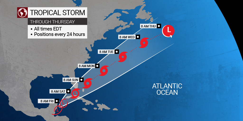
Forecasters are predicting that this area of interest will become a tropical depression on Friday as it moves over the southeastern Gulf of Mexico. It is then likely to head in the direction of the Florida Keys and South Florida on Friday night and into Saturday. There is also a good chance that it develops into a tropical storm while over Florida.
The system is also predicted to bring impacts to the northern Bahamas over the weekend. Even if this system does not develop into a named storm, it is going to bring significant impacts to the Florida peninsula as it cuts a swath through the state, delivering heavy rain and creating rough surf throughout the region.
Should this system become a named storm, it will take on the name of Alex. Maximum wind speeds will need to hit 39 mph for this designation to happen.
How quickly this system intensifies and to what degree depends on a number of influencing factors. Sea-surface temperatures are hovering a few degrees above average topping out in the low 80s. 77 degrees is the widely recognized temperature needed for tropical development.
In addition, wind shear is expected to decrease as the storm approaches the U.S. This decrease in shear will allow the system to pick up speed and intensity. An increase in wind shear typically translates into storms that break apart.
The system will begin to bring impacts to the western edge of Cuba as early as late Thursday. South Florida may begin to see the rains associated with this system by Friday. Rainfall amounts of up to eight inches are predicted for western Cuba. This amount of rain will be enough to potentially trigger flash flooding mudslides through the mountainous terrain.
The Sunshine State will also be under the gun for torrential rains from the Florida Keys all the way up into the central portion of the state. South Florida will likely experience the worst of the rain. Although this rain will be good news for the ongoing drought, too much precipitation in a short amount of time will raise the risk of urban flooding.
Other impacts that this system is forecast to bring include rough surf throughout the southern and central coastlines of Florida and in the northern reaches of the Bahamas. There is also the chance that a tropical event of this nature could spawn tornadoes and waterspouts.
After moving across Florida and through the Bahamas, the predicted path takes the system in a northeastward direction. This would bring it close to the southern Atlantic Coast. While it is not expected to make another landfall, its proximity to the Eastern Seaboard could mean that the southeastern U.S. is in for some level of impacts ranging from rough seas and surf, coastal flooding, significant rainfall, and strong winds.
Unfortunately, some of these impacts may happen to coastal areas that saw significant beach erosion earlier this spring after a non-tropical storm set up shop in the Atlantic. Many stretches of sand stretching from the Carolinas to New Jersey were impacted by this slow-moving storm.
Sharing is caring! Did you find this content useful? Feel free to bookmark or to post to your timeline for reference later!

January 21, 2024

January 19, 2024

January 18, 2024
