
Heavy Rain, Flooding, and Chance of Severe Weather Staring Down the Southern U.S.
January 22, 2024
Posted: May 9, 2022 4:07 pm


Second Weather Maker Will Bring More Rain and Snow to the West Mid-Week
It is going to be a bag of mixed conditions throughout the West this week, including rain and snow. Here is what you can expect in the days to come.
It was a dreary day for much of the Pacific Northwest on Sunday as the first of two major weather makers for the week came on shore. It was rain and snow throughout Washington, Oregon, and Northern California. An injection of much cooler temperatures paved the way for snow to develop in the higher terrains while the lower elevations saw the precipitation fall as rain showers.
By Sunday morning, almost 20 inches of snow was recorded in Oregon near the White River Snow Park. Parts of Montana also saw measurements well over 6 inches.
This rain will continue to push inland throughout the day Monday with snow still hanging around in the highest elevations in the Cascades and Sierra Nevada. Parts of Idaho, Wyoming, Montana, and Nevada will also see May snow in the early part of the week.
Travelers heading out over Snoqualmie Pass on Interstate 90 in Washington need to be aware of the potential of snow causing travel disruptions. The snow level may drop as low as 2,000 feet in this part of Washington. Areas primarily seeing rain may also see a few snowflakes mixed into the falling precipitation.
The reason for the snow lies with temperatures that are far below normal for this time of the year. For example, Seattle will start the week with a high in the lower 50s. This is a dramatic departure from an average reading of about 65 degrees during the second week of May. The readings are even lower once you head up into the foothills of the Cascades, making the potential of snow possible, particularly in the overnight hours when the mercury drops.
Unfortunately for the drought-stricken southern tier of California, there is no rain in the forecast looking ahead. The same goes for the Southwest where the rain is much needed. This storm system will instead deliver strong winds and dry conditions.
Gusty winds measuring over 40 mph are in the forecast for the mountains around Los Angeles stretching through the Rockies and into the northern Plains to start the week. The strongest wind gusts of up to 70 mph are expected in areas to the west of Denver. These winds will bring the potential of blowing dust and isolated power outages through Tuesday.
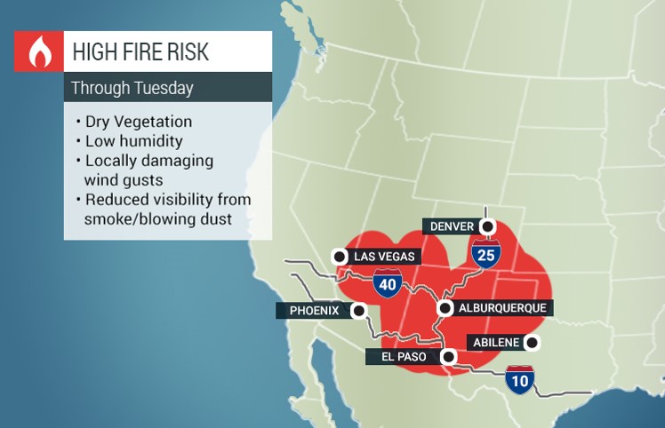
The gusty winds may also create dangerous cross-winds for travelers heading out on some portions of interstates 40 and 70. In addition, the winds will exacerbate the already present fire danger to areas that are in dire need of moisture to temper the dry vegetation.
The greatest risk of fire danger through Tuesday includes the southern tier of Nevada, the bulk of Arizona and New Mexico, and into western Texas and Oklahoma. Not only are these areas not likely to see any precipitation in the coming days, but they will also be the epicenter of the strong winds.
By late Tuesday, the winds will die down and the moisture in the Pacific Northwest will travel into the central part of the U.S. However, another storm system is nipping at its heels, ready to track to the West Coast by the middle of the week.
This storm is expected to move to the south through California early Wednesday before making a turn to the northeast and slamming into the Rocky Mountain region on Thursday. Because of the cooler air temperatures already positioned over the Northwest, the snow will find the necessary atmospheric conditions to shift farther to the south.
The rain will also move farther to the south than the first system, making it possible that areas such as Northern California see some beneficial precipitation out of this system.
High pressure is expected to take up shop in the Southwest by the end of the week, injecting warmer air throughout the West Coast.
Did you find this content useful? Feel free to bookmark or to post to your timeline for reference later!

January 21, 2024

January 19, 2024

January 18, 2024
