
Heavy Rain, Flooding, and Chance of Severe Weather Staring Down the Southern U.S.
January 22, 2024
Posted: June 18, 2021 2:08 pm


Heavy Rain and Wind Forecast for Gulf Coast in Coming Days
The Gulf Coast is now in the line of fire for a potential tropical storm over the next few days. This development would bring heavy rain to a region of the country already dealing with the overly saturated grounds.
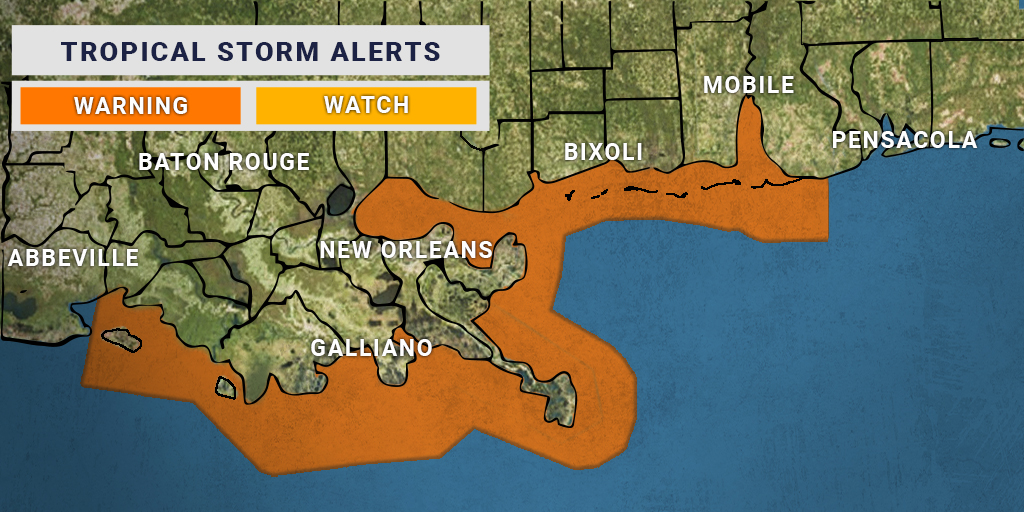
What is Going on in the Gulf: Forecasters at the National Hurricane Center (NHC) are keeping a close eye on a disturbance that is gaining strength over the western Gulf of Mexico. The system may develop into a tropical depression sometime late Thursday or early Friday morning. There is also the possibility that the feature will intensify enough to become a tropical storm.
Should this happen, it would be named Tropical Storm Claudette. Claudette would become the third named storm of the 2021 Atlantic hurricane season, putting it approximately two months ahead of when this normally happens.
The storm is forecast to track toward the Louisiana coastline by early Saturday. While the system is not predicted to intensify enough to move beyond a tropical storm designation, the risk of heavy rainfall necessitates that residents keep a close eye out on the development. The areas most likely to experience flooding as a result of the storm’s landfall are the coastal areas of Mississippi and Louisiana.
Rain and Wind the Story: Even if this system does not develop into a named storm, residents throughout the southeastern US need to be ready for a stormy weekend. If you live in this area and have outdoor plans this weekend, you may want to look into alternative activities.
In addition to the anticipated rainfall, the system will also bring gusty winds. The greatest threat of winds will be in the eastern part of the storm, putting southeastern Louisiana, Mississippi, Alabama, and the Florida Panhandle in the bullseye this weekend as the system moves inland.
The strongest winds are forecast to hit approximately 60 mph as the storm blows in. The stretch of coast most likely to see these winds include the southern sections of Louisiana, Mississippi, Alabama, and the far western reaches of the Florida Panhandle. A bulk of the southeastern states may see winds in the range of 30-40 mph as the storm moves through over the weekend.
Sporadic power outages may plague the Gulf Coast as the winds knock down tree limbs. These outages may happen as far inland as South Carolina and Georgia.
The good news is that the storm is predicted to move at a relatively high rate of speed. This will hopefully help to mitigate the danger of the soaking rainfall. Many areas of Texas and Louisiana are still dealing with the effects of the flooding rainfall that hit the region in May.
Texas Likely to be Spared: The Lone Star State is likely to be spared this time around. Because of the prevalence of dry air on the western edge of the system, Texas is not forecast to see the heavy rain projected for the rest of the Gulf Coast. However, Texans in the eastern coastal areas should be prepared for intermittent rain and the potential of severe weather as the storm moves onshore.
Current Conditions: As of mid-day Thursday the feature is displaying unorganized clusters of rain showers and thunderstorms. The rain is currently positioned over the waters of the central and western Gulf of Mexico with some precipitation moving into southeastern Mexico.
The current wind shear in the area is keeping the system from intensifying at rapid rates. These winds are also bringing dry air into the center of the system, helping to keep the development suppressed. However, forecasters are growing more confident that the storm will undergo greater organization as it moves to the north on Saturday, making it possible that a tropical storm will develop. Because of the wind shear, it is unlikely that the system will progress beyond a tropical storm.

January 21, 2024

January 19, 2024

January 18, 2024
