
Heavy Rain, Flooding, and Chance of Severe Weather Staring Down the Southern U.S.
January 22, 2024
Posted: September 23, 2022 12:47 pm


The Canadian Hurricane Center is warning that Hurricane Fiona could be one of the strongest storms to slam into the eastern portion of the country. Now a Category 3 storm, Fiona is on a crash course for Atlantic Canada in the coming days. Here is the latest on this evolving situation.
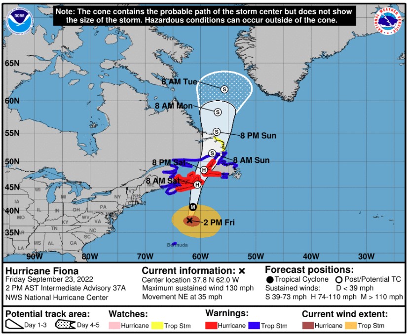
Hurricane Fiona has already been on quite a journey. The storm first came on shore in Puerto on Sunday afternoon, knocking out power to the entire island and triggering destructive flooding. The storm then went on to make landfalls in the Dominican Republic and the Turks and Caicos.
As of Friday morning, what was once a Category 4 storm devolved into a Category 3 hurricane as defined by the Saffir-Simpson Hurricane Wind Scale, featuring maximum sustained winds of 125 mph. Fiona is tracking to the north-northeast at a speed of 25 mph. The storm has picked up speed as it moves closer to Bermuda.
The Canadian Hurricane Center has issued a host of tropical storm warnings and hurricane warnings for the coastal areas of Atlantic Canada with impacts expected by late Friday. The storm is forecast to hit the eastern portions of Prince Edward Island, Nova Scotia, and Quebec. Also in the line of fire are western Newfoundland and the southeastern corner of Labrador.
People in the impact zone can expect to see life-threatening flooding, dangerous winds, and high storm surge. The hurricane-force winds associated with this major storm are expected to extend outward by 115 miles from the center of the feature. What is even more worrisome is that the tropical-storm-force winds are expected to extend for 345 miles from the center, putting a large number of people at risk for these impacts. Widespread power outages are likely with a storm of this magnitude.
Forecasters are predicting that Fiona will make landfall on Saturday morning near Cape Breton Island in Nova Scotia. The storm is predicted to come onshore as a Category 2 hurricane. This strength would deliver impacts that may end up being worse than what 2019’s Hurricane Dorian brought.
In addition to the widespread power outages, the storm is also forecast to bring heavy rainfall and storm surge through the Gulf of St. Lawrence. Wind gusts of up to 120 mph are on tap for eastern Nova Scotia by early Saturday. Winds up to 60 mph may extend as far as eastern Maine and up through eastern Quebec and Labrador.
Rainfall amounts are predicted to fall around 4 – 8 inches through northern Nova Scotia and southwestern Newfoundland. This amount of rainfall is enough to lead to severe flooding. The good news is that Fiona is currently moving at a fast clip which would mitigate the amount of rain that could fall over one particular area. A slowdown of the storm would translate to higher rainfall amounts.
The wrath of Hurricane Fiona will also affect the trees in the region. High winds will take leaves off the trees, putting a damper on leaf peeping opportunities. The falling leaves could also clog storm drains working hard to remove the excess rainwater.
The torrential rain will pair with the strong wind gusts to uproot trees and bring down branches. This could further exacerbate power outages, particularly in areas north of Halifax and southwest of St. John’s.
Storm surge will also be an issue to look out for in some parts of Atlantic Canada. Forecasters are predicting that waves may reach as high as 50 feet in areas off of Cape Breton. This will trigger significant coastal flooding.
While this area has seen its fair share of minor hurricanes and tropical events, the typically cold waters over this part of the North Atlantic tend to mitigate the strength of these storms once they move into the area. However, water temperatures have been running about 10 – 20 degrees above normal over the North Atlantic this year. This means that Fiona will likely not weaken as much as it makes its way to land.
This is only the start of what forecasters with the National Hurricane Center (NHC) are saying is shaping up to be a powerful end to September. There are a number of features churning in the Atlantic basin that have raised the alarm bells of the NHC in recent days.
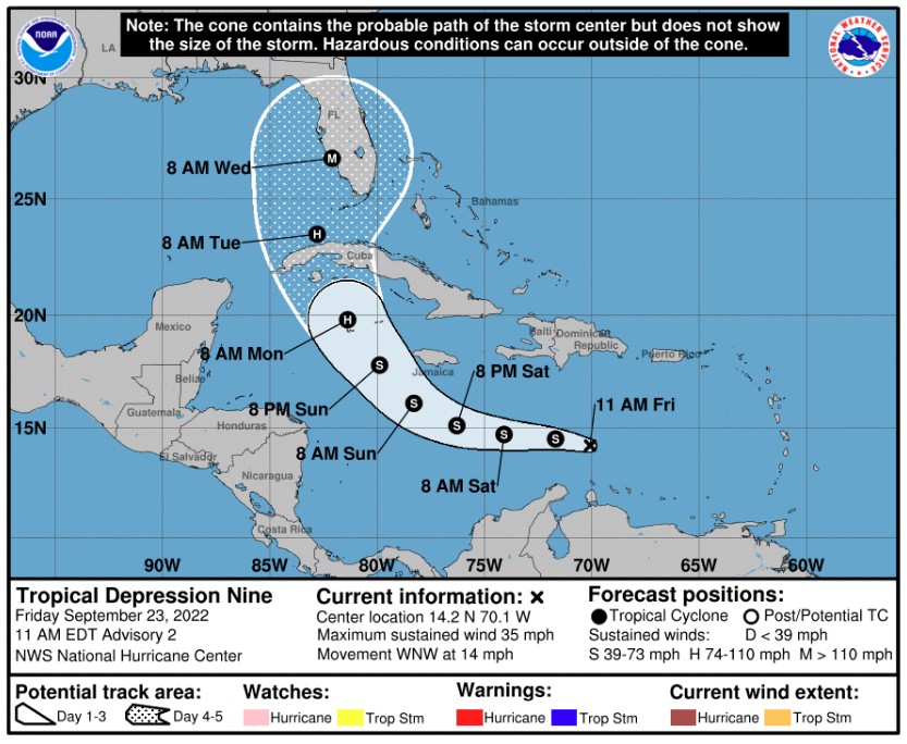
A new tropical depression formed on Friday morning in the central Caribbean. While it is still too early to pinpoint with precision, most models show this storm moving into the eastern Gulf of Mexico and gaining intensity and size. The computer models indicate that this tropical feature could make landfall along the Gulf Coast of Florida by the middle of the week. Stay tuned for the latest on this development.
Did you find this content useful? Feel free to bookmark or to post to your timeline for reference later.

January 21, 2024

January 19, 2024

January 18, 2024
