
Heavy Rain, Flooding, and Chance of Severe Weather Staring Down the Southern U.S.
January 22, 2024
Posted: September 26, 2022 1:03 pm


Mandatory evacuations are now underway for parts of Hillsborough County, including part of the Tampa Bay Area, as Hurricane Ian continues to strengthen and move toward the Florida Gulf Coast.
What was a mere tropical storm on Sunday strengthened into an official hurricane in the overnight hours. As expected, Ian continues to gain strength as it moves closer to the Florida peninsula. While Ian is just a Category 1 storm as of the middle of the day Monday, forecasters with the National Hurricane Center (NHC) are certain that the storm will intensify in the coming hours, reaching as high as a Category 4 monster by the middle of the week.
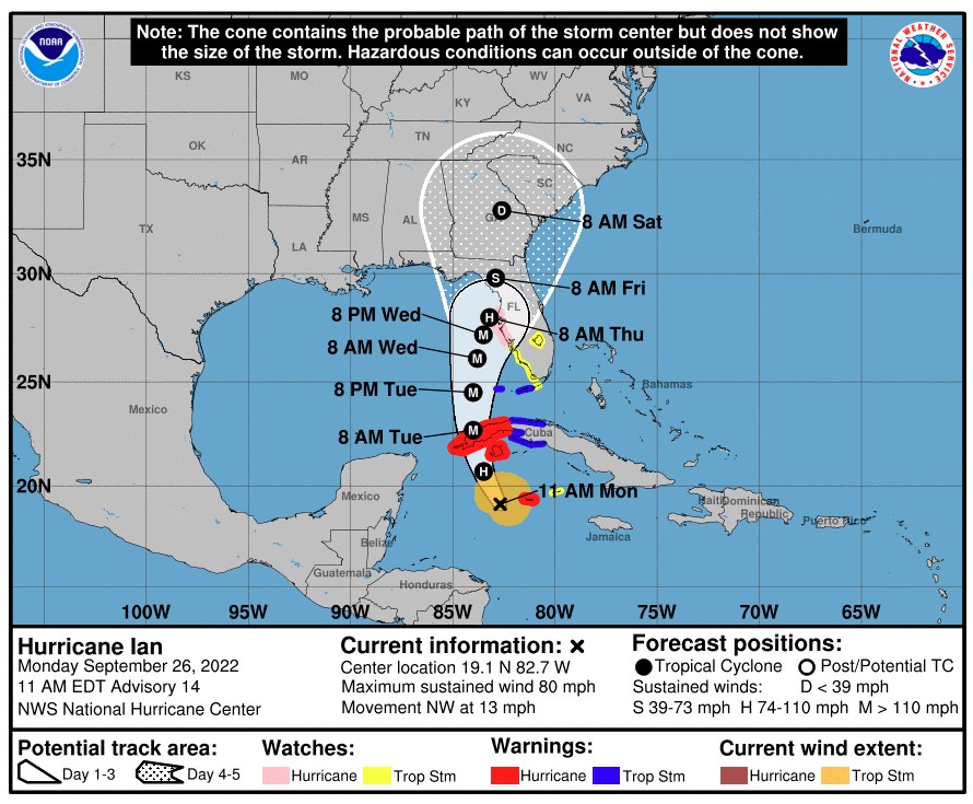
As of 11 am EDT Monday, Hurricane Ian was packing maximum sustained winds of 80 mph while it tracked to the northeast at a speed of 13 mph. Ian is spinning west of the Cayman Islands and Cuba with the western portions of Cuba forecast to take a direct hit by 8 am local time on Tuesday. At this point, most models forecast that Ian will be a Category 3 storm when it moves over Cuba.
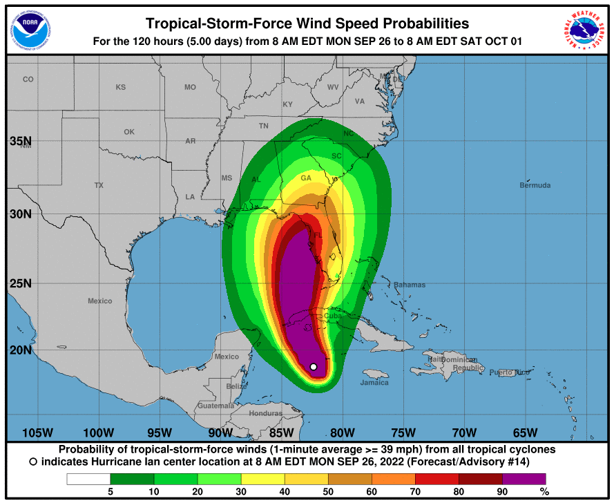
The current update from the NHC indicates that hurricane-force winds extend up to 25 miles from the center of the storm. The tropical-storm-force winds are creating a wider path, extending outward up to 115 miles.
While Ian was a Category 1 storm as of midday Monday, forecasters say that it is about to move into an area of more favorable environmental conditions for further development. After becoming a named storm on Friday, the feature’s ability to remain organized was mitigated by areas of strong wind shear that limited how quickly it could intensify.
However, the feature is now tracking toward an area with limited wind shear in the western Caribbean. In addition to lower amounts of wind shear making way for rapid intensification, the storm is also moving into the bath-water warm temperatures of this part of the Caribbean and the Gulf of Mexico.
Ian is forecast to be a major hurricane by early Tuesday. Western Cuba will be the first major populated area to see the impacts of this storm as it moves north over the island. Hurricane warnings are already in place for some parts of the island.
Cuba will begin to see the impacts by the end of the day Monday. Heavy rainfall and strong winds will be the first signs that the storm is moving closer. The worst of the conditions are forecast for Tuesday morning for the western third of the island.
Storm surge of over 6 feet is predicted for the hardest hit areas of Cuba. Wind gusts are forecast to hit up to 140 mph. Unfortunately for those in Florida hoping to avoid a major hurricane, Ian is expected to miss the higher terrains of Cuba that tend to break up these tropical events. This means that it is becoming more likely that Ian will eventually reach the destination of a Category 4 storm.
A southward dip in the jet stream in the U.S. will pull the storm to the north and closer to the mainland. The timing of this pull will determine the precise track of Ian. This dip in the jet stream will also influence to what degree Ian will strengthen by the time it makes its anticipated landfall in Florida.
Forecasters are also keeping a close eye on the increasing amounts of wind shear circulating in the northern Gulf of Mexico. The system could weaken considerably if it reaches this inhibiting shear prior to making landfall in Florida. This timing could mean the difference between a major hurricane strike or a less intense storm.
A faster acceleration of the jet stream dip would guide the storm toward the west before it has a chance to meet up with the high wind shear. This would translate to a greater chance of a major hurricane strike. Conversely, if the jet stream dip takes its time, Ian may drift farther to the north and interact with the high wind shear enough to weaken it before it makes landfall in Florida.
Even if Ian is not a major hurricane when it reaches the Florida coastline, the region is still forecast to be inundated with large amounts of rain. The heaviest of the rain will come east of the eye of the storm. Tampa, Orlando, and Jacksonville could see widespread rain between 4 – 8 inches.
The resulting storm surge will also be a threat regardless of how quickly the storm intensifies. The Tampa Bay area should be ready for a water rise of 6 – 10 feet.
It was a busy weekend across Florida’s Gulf Coast as residents prepared for the impending arrival of Ian. Florida Gov. Ron DeSantis declared a pre-emptive state of emergency for the entirety of the state over the weekend. The governor also announced on Monday that he has activated 5,000 members of the National Guard to be ready to help after the storm makes landfall.
Hillsborough County Public Schools announced that it will close for much of the week. Bethune-Cookman University in Daytona Beach announced a mandatory campus evacuation for Monday. Many of the area’s government offices also ordered shutdowns.
Tampa’s MacDill Air Force Base issued a mandatory evacuation by noon Tuesday for all non-mission essential individuals. This is all in addition to the approximately 300,000 people under the Hillsborough County evacuation notice.
Elsewhere in the state, Hernando County declared a local state of emergency on Monday. Officials have issued voluntary evacuation orders for the low-lying portions of the county as well as for those living in mobile homes.
Did you find this content useful? Feel free to bookmark or to post to your timeline for reference later.

January 21, 2024

January 19, 2024

January 18, 2024
