
Heavy Rain, Flooding, and Chance of Severe Weather Staring Down the Southern U.S.
January 22, 2024
Posted: October 4, 2021 11:55 am


October is historically the third-busiest month for tropical developments in the Atlantic basin. This trend means that forecasters with the National Hurricane Center (NHC) are keeping a close eye on the Atlantic for potential new tropical activity. What are they looking at this week and how may this weather affect you? Read on for more information.
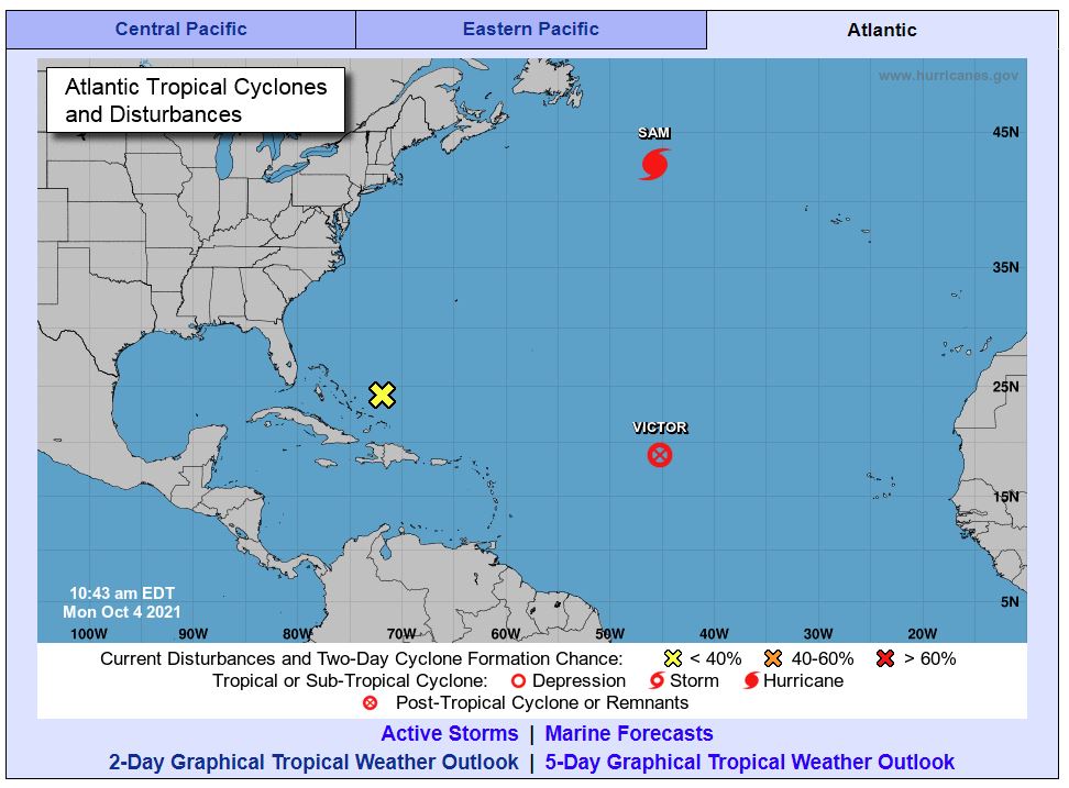
The western Atlantic will be a zone of high interest in the coming days as an area of low pressure that is currently positioned to the north of Hispaniola will begin to move to the west and northwest. Even though the location of this feature could spell trouble for the US, the chances of it developing into a tropical depression or storm are still somewhat low. This is because the area is expected to encounter strong wind shear that will likely hinder its development.
In addition to this area of low pressure, Hurricane Sam is the storm that just will not die. Sam formed on September 23 and continues to put on a show. Although the monster storm has not threatened any major land masses, it will be distinguished for its longevity in the record books.
As of late Sunday, Sam had weakened to a Category 2 storm with maximum sustained winds of 105 mph. At one point, the wind speeds generated by Sam were just a few miles shy of a Category 5 designation.
Elsewhere in the basin, Tropical Depression Victor continues to move to the northwest at a speed of 15 mph as it churns in the central Atlantic. While there is still a chance that this system could strengthen into a hurricane for a short time, it is not predicted to threaten any land along its journey in the Atlantic Ocean. The system is forecast to break apart by late Wednesday as it meets with strong wind shear in its path.
With last week’s development of Victor, there is only one name left on the official list of storm designations for 2021. Once Wanda forms, forecasters will lean on a new supplemental list that has been designated by the World Meteorologist Organization.
Forecasters are also keeping a close eye on a slow-moving front that is moving across the southeast corner of the US in the coming days. The front is predicted to bring up a heavy band of tropical moisture from the Gulf of Mexico. While many areas of the nation would welcome this precipitation, this particular region has already been drenched in recent weeks by the landfalls of Hurricane Ida and Hurricane Fred.
This surge of moisture will likely move into the southeast Atlantic Coast by the middle of the week. This could trigger tropical downpours and gusty winds. This weather will be primarily confined to the Southeast, hitting the entirety of Florida and stretching up into Georgia and the Carolinas.
While it is unlikely, there is the possibility that this area of heavy moisture will meet with the area of low pressure spinning around near the Bahamas. Should this happen, it could be an exceptionally wet and windy week with the potential of flooding and other damage along the southeast coast of the US. In addition, there is a good chance of severe thunderstorm activity as the week comes to a close.
The one thing that is for certain is that the weather pattern will be unsettled and active over this corner of the nation throughout the week. Residents should monitor their local forecasts to keep on top of this fluid situation. Because hurricane season does not officially end until November 30, nobody can afford to let their guard down yet.

January 21, 2024

January 19, 2024

January 18, 2024
