
Heavy Rain, Flooding, and Chance of Severe Weather Staring Down the Southern U.S.
January 22, 2024
Posted: September 22, 2022 11:14 am


While it is Hurricane Fiona that is grabbing all of the headlines in the tropics over the last few days, there is another threat that is currently brewing in the southern Caribbean. This latest development in the Atlantic Ocean could threaten the mainland U.S. by the end of the month.
National Hurricane Center Keeping Busy Monitoring Tropics
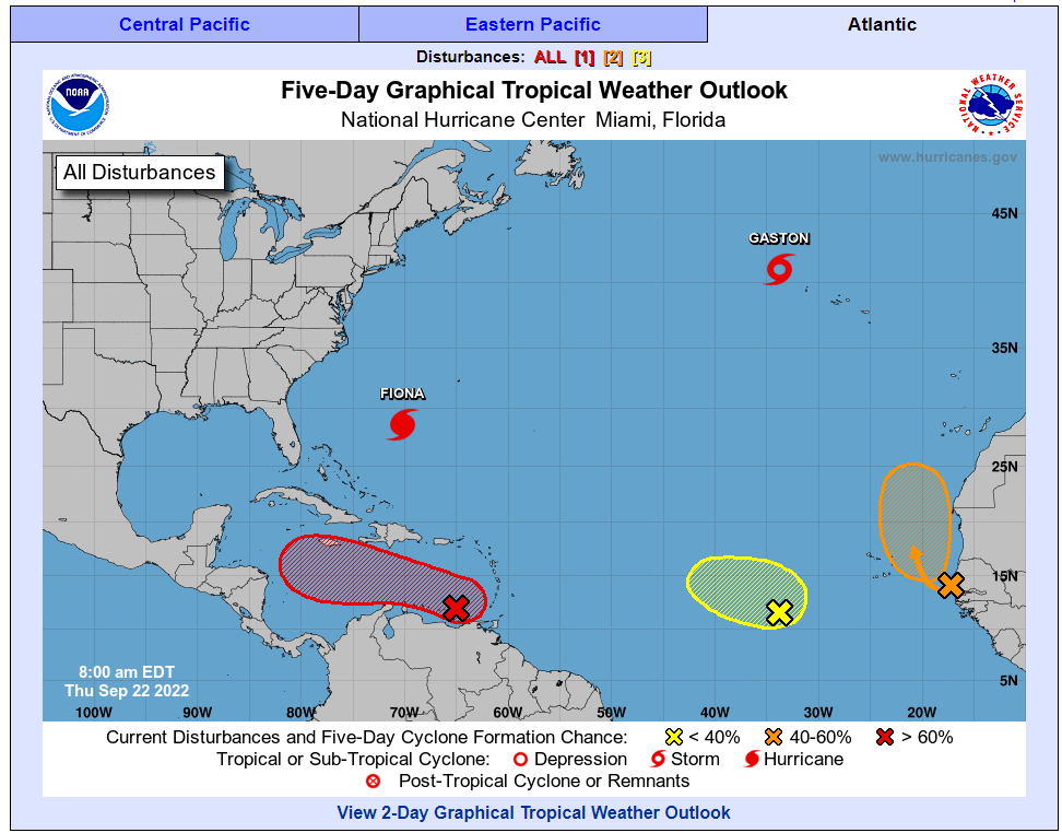
The tropics have been active throughout the month of September after they fell eerily quiet in August. There are a number of features that the National Hurricane Center (NHC) is keeping an eye on as the month comes to a close.
What was first referred to as Tropical Depression Eight on Tuesday morning in the Atlantic only took a few hours to develop into Tropical Storm Gaston. Although Gaston is not expected to bring any significant impacts to the U.S. or the Caribbean, the storm could douse the Azores with heavy rain, strong winds, and rough seas later in the week. There is also the chance that this storm could intensify into a hurricane by the weekend.
As of late Wednesday, Tropical Storm Gaston was circulating about 700 miles west of the Azores with maximum sustained winds of 65 mph. The feature is moving to the northeast at a speed of 14 mph.
In addition to Gaston, hurricane watchers are also closely monitoring a robust tropical wave that started to organize better over the western portions of the Atlantic on Wednesday. This is in addition to another feature that was moving over western Africa on its way out into the Atlantic. This system is predicted to move into an area of favorable atmospheric conditions in the next few days, triggering what could be a rapid and intense organization by the end of the week.
Invest 98L Gaining in Size and Intensity
However, what is garnering the most eyeballs is a strong tropical wave that has been designated as Invest 98L. This tropical rainstorm is currently spinning near the north-central coast of South America, threatening to move toward the direction of the U.S.
This system could develop into a tropical storm by Friday if the primary portion of the feature does not interact with South America. Other land masses that may break it up include areas of Central America or the large island of Cuba.
The rainstorm could intensify further once it moves into the warm waters of the central and western parts of the Caribbean this weekend. This is when it is most likely to meet up with the favorable conditions for development. In addition to the warm waters that are hovering in the 80s in this part of the Atlantic, there is also little to no wind shear projected to disrupt the system.
Forecasters are warning that the rainstorm may find some pockets of water that are as warm as 90 degrees. These exceptionally warm waters could accelerate the strengthening of this system.

The track of this potential development would largely depend on the steering breezes in the region. If the storm develops quickly, it is more likely to move to the north at a faster clip. Conversely, a weaker system would not make this turn as quickly.
Should the system pass over a land mass such as Cuba or Mexico, this interaction could stymie its intensification. Hurricane experts are cautioning that the southward dip currently in the jet stream that is keeping Hurricane Fiona at bay may not be enough by the weekend to steer this developing system away from the U.S.
However, another dip in the jet stream could also trigger the southerly breezes that could send the storm into the Florida Straits or toward the eastern Gulf Coast. It is still way too early to determine where this feature ends up with a variety of possibilities still on the table.
This means that any area stretching from Fort Lauderdale to Houston should be on alert for the potential path of this tropical rainstorm. There is also the possibility that the storm could take a northward path past Florida and toward the Atlantic Seaboard.
As of now, it is not expected that this feature could track toward the areas of the Caribbean that were just hammered by Hurricane Fiona. It is also possible that the storm could make a beeline to the Gulf of Mexico. This path would mean that it would intensify at a faster rate since the waters in this part of the world are so warm this time of the year.
Should any of these features of note develop into another named storm, the next names on the list for this season are Hermine, Ian, and Julia.
Did you find this content useful? Feel free to bookmark or to post to your timeline for reference later.

January 21, 2024

January 19, 2024

January 18, 2024
