
Heavy Rain, Flooding, and Chance of Severe Weather Staring Down the Southern U.S.
January 22, 2024
Posted: May 18, 2022 11:00 am


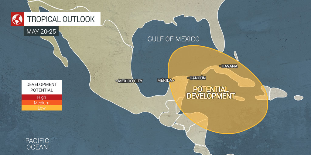
Central America Gyre Could Be in the Cards This Week, Triggering Tropical Development
With just a few weeks left in May, hurricane watchers are keeping a close eye for signs of the first tropical development of the season. Meteorologists are monitoring the waters of the western Caribbean and the south-central Gulf of Mexico looking for signals that would indicate the potential of tropical development. While the official start of the tropical weather season as defined by the National Hurricane Center (NHC) is not until June 1, there has been early season development in May in each of the last seven years.
Satellite photos are indicating that clouds demonstrating the potential of tropical development are beginning to come together over a portion of Central America. In addition, an area of thunderstorm activity positioned over part of the Caribbean is raising red flags.
Forecasters are predicting the formation of a low pressure area with a weak rotation taking root later this week in Central America. Known as the Central American gyre, this pattern typically produces the movement in the atmosphere that can trigger tropical development. This is particularly true if the gyre moves over the warmest waters of the region.
This is the part of the Atlantic basin that has been known to spur tropical storms early in the season, primarily because of its warm sea-surface temperatures. Some of these areas are seeing water temperatures that are a few degrees above normal for the middle of May, making this development even more of a possibility. Water temperatures throughout this region of the Caribbean are hovering in the low to mid-80s.
The potential of a tropical system may depend on where the center of the gyre forms. For instance, if the gyre develops to the west or over a land mass, any potential disturbance may move inland or out into the Pacific Ocean. However, if this gyre develops farther to the east, it would have a higher potential of moving to the north and into the southern Gulf of Mexico. This type of movement would track it closer to land while also raising the chances that it has to intensify due to the open waters.
Should a tropical system form, it would likely happen over the weekend or early next week. There are a number of factors at play that could influence the development and direction of any potential activity. For example, if a high pressure area forms over the southern portions of the U.S., it could steer any potential tropical development toward Central America or the southeastern corner of Mexico. There is also the chance that the position of a high pressure area could force any tropical events toward the western and central Gulf Coast, taking aim at the U.S.
If the high pressure area is not strong enough, the development would be more likely to drift closer to the eastern Gulf Coast, including Southwest Florida. It is important to note that the track of the storm is impossible to determine at this point.
Sharing is caring! Did you find this content useful? Feel free to bookmark or to post to your timeline for reference later!

January 21, 2024

January 19, 2024

January 18, 2024
