
Heavy Rain, Flooding, and Chance of Severe Weather Staring Down the Southern U.S.
January 22, 2024
Posted: September 19, 2021 4:49 pm


As fall starts this week in the US, the tropics are still churning out multiple features. Tropical Storm Odette was downgraded to a tropical rainstorm on Saturday morning as it continued to drop rain off the New England coast. Meanwhile, a new tropical storm formed over the weekend near the Leeward Islands in the Atlantic. Here is the latest on the Atlantic hurricane season.
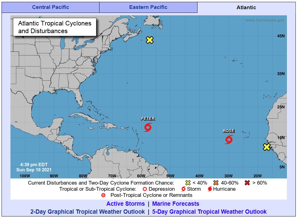
Forecasters at the National Hurricane Center (NHC) have been kept busy over the last few days monitoring what is now Tropical Storm Peter. The system formed off of the African coast last week, moving quickly through the Atlantic on its way to the Caribbean. By early Sunday, the feature had slowed down enough to be able to strengthen and form a tropical storm.
As the 16th named storm of the 2021 season, Peter is now churning about 630 hundred miles east of the northern Leeward Islands. The storm is expected to bring rough surf and heavy rain to the Leeward Islands, Puerto Rico, and the Virgin Islands beginning on Sunday and continuing through Tuesday.
Bermuda is likely to be in the crosshairs later in the week as Peter continues to churn in the Atlantic. The islands may experience enhanced tropical downpours, strong winds, and rough sea conditions late this week and into next weekend.
Tropical Storm Peter is boasting maximum sustained winds of about 45 mph as it moves to the west and northwest at a speed of 17 mph. At this point, the forecasted trajectory of the storm does not have it impacting the US mainland. A cold front that is moving east across the US will serve to block Peter from advancing to the Eastern Seaboard, keeping the system well out to sea.
Peter is not forecast to strengthen beyond a low-end tropical storm due to unfavorable environmental conditions. This includes a mass of dry air that is surrounding the storm. In addition, an increasing amount of wind shear will work to prevent Peter from developing. A dip in the jet stream near the East Coast will also work to keep Peter tamed.
Meanwhile, another tropical depression officially formed on Sunday morning near the Cabo Verde Islands off of the coast of Africa. This tropical feature is delivering strong thunderstorms and heavy rains. It is not out of the question that this depression will intensify into a tropical storm within the next 24 hours.
A reduction in the wind shear in the area will give the depression the opportunity to intensify more in the coming hours. Should this feature develop into a named storm, it will go by the name of Rose.
Although the current warm sea-surface temperatures and the lack of wind shear and dry air will allow the depression to increase its intensity, it will move into unfavorable conditions over the next few days that will likely suppress its chances for further development.
The increase in wind shear is predicted to happen by Monday night. This makes forecasters relatively certain that the storm will break apart starting on Tuesday. The track has the storm moving into the central Atlantic later in the week before diminishing in strength.
The tropical depression is forecast to deliver locally heavy downpours and dangerous rip currents to the Cabo Verde Islands over the next 48 hours.

January 21, 2024

January 19, 2024

January 18, 2024
