
Heavy Rain, Flooding, and Chance of Severe Weather Staring Down the Southern U.S.
January 22, 2024
Posted: March 26, 2021 3:05 pm


A strong storm system that brought heavy rain and flooding to the southern states and the mid-Atlantic is marching toward the Northeast as the week comes to a close.
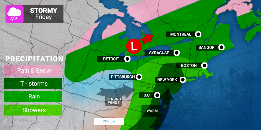
Thunderstorms on Tap: Everywhere from the central Appalachians up through New England is in the path of the threat of severe weather on Friday. Residents may be caught off guard by the rumble of thunder in areas that have not seen a hint of a thunderstorm since last fall. These storms are expected to move quickly through the region, alleviating the risk of soaking rains and widespread flooding.
Cities that are in the path of the rain and thunderstorms throughout the day on Friday and into the overnight hours include Washington, DC, New York City, Philadelphia, Boston, and Syracuse. The temperatures will be warm enough that the precipitation will only fall as rain except for the far northern reaches of Maine where it may drop as snow.
The storms will likely bring hail, strong winds, and heavy rains as they rush through the region.
Deadly Day for Gulf Coast: After a deadly rash of tornadoes that took the lives of six in Alabama and Georgia on Thursday, the south-central US is bracing for more tornadic activity heading into the weekend. Thursday’s day of destruction was one for the record books. The National Weather Service (NWS) Storm Prediction Center recorded 23 total tornadoes throughout the Gulf Coast region and into Georgia.
Another storm system is predicted to move in from the central Plains and Great Lakes over the weekend, delivering the risk of more severe weather right back into the southern states. As the warm and moist air nudges northward from the Gulf of Mexico on Saturday, the system will have the moisture that it needs to trigger another round of severe weather over the weary Gulf Coast.
The line of severe weather is likely to stretch from central Kentucky down into portions of Louisiana, Mississippi, and Alabama. While the tornadic activity is not expected to rival what the region saw on Thursday, an isolated twister is not out of the question. Damaging winds, large hail, and heavy rain should be expected. Residents should also be prepared for power outages, downed trees, and flooded roadways.
Cities in Path of Weekend Storms: The major cities that may see the impacts from the weekend severe weather include Memphis and Nashville in Tennessee and Jackson, Mississippi. Birmingham, Alabama is also in the bullseye. This area of Alabama is still cleaning up from the tornadoes that blew through on Thursday.
As the weekend progresses, the risk of severe weather will move to the east, bringing rain and the potential of thunderstorms to the Southeast and mid-Atlantic on Sunday.

January 21, 2024

January 19, 2024

January 18, 2024
