
Heavy Rain, Flooding, and Chance of Severe Weather Staring Down the Southern U.S.
January 22, 2024
Posted: February 18, 2022 6:28 am


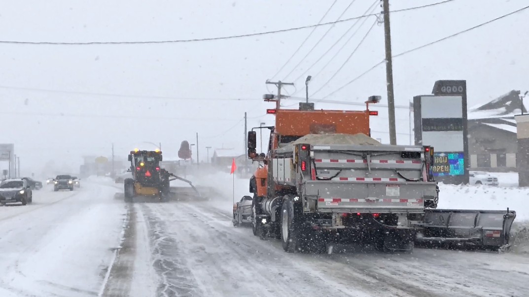
A major snowstorm brought life to a standstill throughout much of the Midwest on Thursday. As this system pushes to the east on Friday, the temperatures will also continue to drop along with the storm’s movement.
Despite enjoying springlike temperatures on Wednesday, the Northeast is still not done with winter. The mercury is forecast to plummet on Thursday night and into Friday as the system that brought record-breaking snow to parts of the Midwest late Wednesday and into Thursday will track to the east over the next several hours. This multifaceted storm is bringing a variety of winter weather conditions, creating dangerous road conditions and closing schools in its wake.
All that the Northeast needs to do to learn what is in store for Friday is to look at what happened in the Midwest with this system on Thursday. Kansas City broke a record for the most amount of snow on February 17 when 6 inches had fallen by mid-day. This amount of snow broke a record that had stood for 129 years. Schools were closed throughout the region as snow continued to fall throughout the day.
It was a nice start to the week throughout much of the Northeast. However, that is also changing as the temperature drops 10 to 20 degrees below average for the middle of February. The temperature shift is moving from west to east, starting in the Plains before continuing into the Midwest and finally the Northeast by Friday.
In addition to the shock of the temperature change, the shift will also allow areas of standing water to freeze over. Because the system may first bring rain to many regions, the efforts of road crews to pre-treat roads in advance of the snow will likely wash away with the water. Forecasters are warning that all of these factors will combine to create a slippery mess for much of the region.
Residents of the Ohio Valley and the lower Great Lakes may wake up to a messy commute on Friday morning. A number of major highways may be impacted by this winter precipitation, including parts of interstates 40, 49, 55, 65, 69, 70, 75, 80, and 90.
Hundreds of flights were cancelled on Thursday throughout some of the nation’s busiest hubs. This includes flights in and out of Chicago, St. Louis, and Detroit. You can expect these mass cancellations to continue on Friday with the bulk of the travel delays centered in the Northeast as the storm advances.
This temperature whiplash has already been the story for much of the Midwest. Temperatures were hanging out in the mid-60s in Kansas City throughout Wednesday. However, the mercury went on a downward spiral once the sun went down, dropping up to 40 degrees.
By the time residents woke up on Thursday, the readings were in the low 20s with snow covering the ground. Temperatures are expected to dip into the single digits by early Friday. The good news is that the wintry precipitation is over for a time.
The story was the same in Chicago. The temperature dropped to about 30 degrees at sunrise on Thursday in advance of the onset of snow flurries. More cold weather is on the way for the Windy City for Friday. Detroit also saw temperatures tumble throughout the day Thursday after residents enjoyed readings in the 50s on Wednesday.
The rain that fell during the middle of the week quickly changed to snow as the temperature dropped. The expected high for Friday in the Motor City is only in the mid-20s.
Even in cities that may avoid the snow, such as Cincinnati, the temperature will still make it clear that winter is in the air.
There is substantially less snow expected to fall in areas east of Ohio. However, the persistent rain to end the week will lead to rapidly melting existing snow with the potential of flooding. The drop in temperatures on Friday may cause some of this standing water to freeze up.
While the temperature shift will not be as drastic in the far northeastern cities of New York City and Boston, the changing weather will still serve as a reminder that winter is far from over.
For example, after enjoying temperatures in the 60s on Thursday, the forecast high on Friday for the Big Apple is only in the 30s. By nightfall, the temperature will drop into the mid-20s.
While this system will not bring the chance of significant snow to the Northeast on Friday, an Alberta clipper may deliver isolated snow showers to this region as well as to the Great Lakes. Locally heavy snow squalls and strong winds are also possible as this fast-moving clipper advances.
After a brief reprieve over the weekend, another cross-country storm is setting up to take aim at the central and eastern states by Tuesday and Wednesday.

January 21, 2024

January 19, 2024

January 18, 2024
