
Heavy Rain, Flooding, and Chance of Severe Weather Staring Down the Southern U.S.
January 22, 2024
Posted: May 27, 2022 11:24 am


Warmth Will Be the Story in the Southern Tier of the U.S.
While the weather will start dreary in the Northeast for the Memorial Day weekend, there is hope that the sun will make an appearance in the latter part of the holiday. However, just as the weather conditions start to improve throughout the Northeast, conditions will begin to worsen over the north-central U.S.
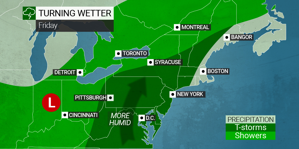
The storms that have been wreaking havoc in the central U.S. are moving into the eastern portion of the country on Friday. The timing of the arrival of this weather maker may cause issues for travelers taking to the roads and air in advance of the holiday. Heavy rains and severe thunderstorms are in the forecast for much of the East Coast beginning on Friday and continuing through Saturday. This includes a large area of the Appalachians and the Atlantic Seaboard under the gun for messy conditions to kick off the official start of summer.
According to AAA, nearly 40 million Americans are predicted to travel over 50 miles from home over the three-day weekend. This figure translates to an increase of 8.3% from last year, equaling pre-pandemic levels. Of this number, over 3 million will be traveling by air. Unfortunately for these travelers, the weather may pose problems at the beginning of the weekend for those in the eastern half of the nation.
Some of the hardest-hit areas may see rainfall rates of up to one inch per hour. Rain falling this quickly can trigger pooling water on roadways while also hampering visibility. Be sure to exercise caution if heading out on the roads when it is raining.
If the rain comes down hard enough, it is possible for small waterways to spill over their banks. This means that those out celebrating the holiday with a camping adventure need to pay attention to the risk of rapidly rising water in low-lying areas located near streams. Those spending time outdoors this weekend should also be prepared for lightning strikes with these severe storms.
The line of storms is forecast to impact a 1,000-mile-long area of land expanding from the southern reaches of Georgia into eastern New York state throughout the day Friday. These storm cells will deliver the chance of strong winds, large hail, and isolated tornadoes. Saturday’s storms will migrate farther to the northeast, impacting states from Maryland through Maine.
The weekend is not expected to be a total wash. As the weather maker continues to track to the north and east, it will eventually move out to sea, bringing along the warm and dry air from the central U.S. Temperatures will begin to climb in the Northeast with widespread readings in the 80s on tap for both Sunday and Monday. Some of the warmest areas may approach 90 degrees by the time the weekend comes to an end, signaling the start of summer in earnest.
Forecasters warn that despite the warm air temperatures, beach-goers need to be prepared for cool waters in the ocean and lakes. Ocean water temperatures are still in the 50s and 60s along the Eastern Seaboard north of Virginia. This raises the risk of cold water shock, making it important that you proceed with caution.
Most areas of the Northeast will be in for a beautiful Memorial Day, paving the way for patriotic celebrations, parades, and tributes to the nation’s veterans. This is a clear departure from the dreary conditions that plagued this corner of the country last year on this same holiday weekend. Not only was it a soggy mess throughout the region but temperatures were also measured at about 20 degrees below normal for the end of May.
Looking at the week ahead, the dry and warm weather is set to continue into the first days of June for the Northeast and the mid-Atlantic. In fact, there is a good chance that the first official heat wave of the year for the region may grab headlines beginning on Tuesday. Many of the most populated cities in the area, including Philadelphia and Washington, D.C., are setting up to see the mercury soar into the 90s by the middle of the week and stay there for a few days.
The south-central and southeastern portions of the country are expected to see heat build throughout the weekend with mostly clear conditions in store. It should be great weather for the 106th running of the Indianapolis 500 on Sunday. The Southwest will also continue to deal with gripping heat.
Areas that can expect to see moisture this weekend include the Pacific Northwest, the northern Rockies, the northern Plains, and the Upper Midwest. A duo of potent storms is forecast to track through the Northwest to start the weekend, delivering rain in the lower elevations and snow in the highest terrains of the northern Rockies.
Scattered showers and thunderstorms are in the forecast on Saturday for parts of the Dakotas and over into Nebraska and Minnesota. This zone will continue to be at risk of moisture on Sunday and Monday with the storms expanding to the southeast later in the weekend, bringing Iowa, Wisconsin, and Kansas into the fold.
Sharing caring. Did you find this content useful? Feel free to bookmark or to post to your timeline for reference later!

January 21, 2024

January 19, 2024

January 18, 2024
