
Heavy Rain, Flooding, and Chance of Severe Weather Staring Down the Southern U.S.
January 22, 2024
Posted: September 26, 2022 3:31 pm


While all eyes are rightfully on Florida as Ian makes its approach toward the U.S., it is important to note that a large swath of the East Coast is likely to see the impacts of the ninth named storm of the 2022 Atlantic hurricane season.
Ian is forecast to strengthen into a major hurricane by the time it finishes its journey through the northwestern Caribbean Sea and the Gulf of Mexico. Should this prediction come to fruition, Ian will deliver heavy rain and strong winds to much of Florida. Although Florida is forecast to bear the brunt of Ian’s wrath, the storm will also impact a number of additional states stretching from the Southeast up into the mid-Atlantic by the end of the week.
After Ian makes landfall along the Gulf Coast of Florida, it is projected to move into the southeastern corner of the U.S. still packing a potent punch. Southern Georgia may begin experiencing the outer bands of rain as early as late Wednesday. Tropical-storm-force winds are likely to begin hammering the Peach State by Thursday morning as the storm continues its northeastern track.
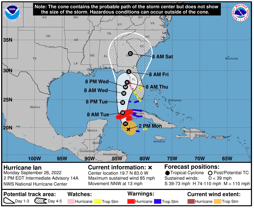
Although the storm will begin to lose its wind intensity as it continues to move across the Florida Peninsula and into the Southeast, it is still likely that parts of Georgia, South Carolina, and North Carolina experience high winds. For instance, the southern tier of Georgia should be prepared for gusts of up to 100 mph. Southeastern South Carolina and Georgia, including the cities of Charleston and Savannah, need to be ready for gusts up to 80 mph.
Winds of this magnitude will almost certainly trigger travel delays in the air and on the roads. High-profile vehicles will need to be particularly aware of the potential of high wind gusts.
In addition to the strong winds, the storm will bring tropical rainfall to a handful of states through next Saturday. The rainfall impacts will be even more severe if the storm slows down and stalls over a particular area.
Widespread flooding may happen well into the Carolinas through the end of the week. The heaviest rains will likely fall across the center of the storm and in the eastern half. Rainfall amounts are likely to total 2 – 4 inches throughout the majority of Georgia, the Carolinas, and southern Virginia. This means a soggy end to the work week for cities such as Williamsburg, Virginia, Charlotte, North Carolina, and Augusta, Georgia.
The coastal areas will likely pick up the most rain with 4 – 8 inches of rain expected along the coastlines of Georgia, South Carolina, and the southeastern corner of North Carolina. The incoming tropical precipitation associated with Ian will merge with the extra moisture from the Gulf Stream waters across the Atlantic Ocean to create a deluge of rain.
Not surprisingly, this amount of rain will also raise the risk of coastal flooding as Ian moves inland. An area of high pressure anchored over the Northeast will trigger onshore winds in an area stretching from Georgia up to Virginia. These winds will likely generate strong rip currents and rough surf conditions, leading to the potential of minor beach erosion.
Lastly, it is also not unusual for storms of this nature to spin up tornadoes within the rain bands. Although these twisters are generally weaker than those that you find outside of a tropical weather event, there is still the possibility that they could inflict significant damage. Areas to the east of a storm’s center are most likely to see tornadic activity, putting Georgia, South Carolina, and North Carolina at the greatest risk.
The bottom line is that Florida will not be the only state in the line of fire for the impacts from Ian. Anyone living in Florida, the Southeast, or the mid-Atlantic needs to keep an eye out on this developing weather situation in the coming days.
Did you find this content useful? Feel free to bookmark or to post to your timeline for reference later.

January 21, 2024

January 19, 2024

January 18, 2024
