
Heavy Rain, Flooding, and Chance of Severe Weather Staring Down the Southern U.S.
January 22, 2024
Posted: June 24, 2022 3:44 am


The northern Plains have been the beneficiary of a cold front that has snapped the record heat that had been plaguing the region in recent weeks. However, this pleasant weather pattern of dry and cooler conditions is about to end as the threat of thunderstorms bears down on the region to close out the week.
The Upper Midwest and northern Plains have been enjoying moderate weather over the last few days, particularly when compared to the heat earlier in the week. After Monday’s rash of severe storms, conditions have been primarily calm. Enjoy the calm while you can as another round of storms is set to impact the northern tier of the U.S. on Friday.
In addition, the heat dome currently parked over the south-central U.S. will stretch to the north on Friday, bringing back warmer temperature readings for the end of the work week. Humidity levels will also increase with the arrival of the heat and the storms.
For example, Minneapolis will experience temperatures in the low 90s on Friday with partly cloudy skies and the chance of a shower or thunderstorm.
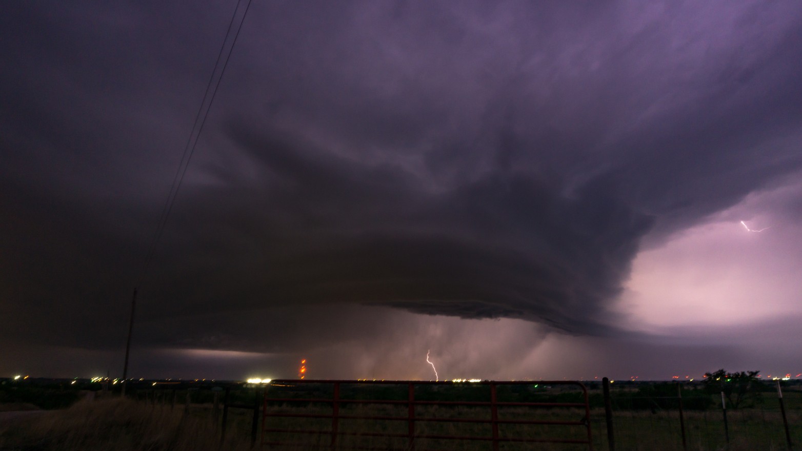
Forecasters are warning that it is likely that a significant portion of the predicted severe weather will take place in the overnight hours. Storms that hit under the cover of darkness are particularly dangerous as residents may be caught off guard.
The heat will be on across the northern Plains with Friday’s high temperatures averaging 6 – 12 degrees above normal for this time of the year. High humidity levels will bring the real feel temperatures to greater levels of discomfort. This humidity will also help to fuel the development of thunderstorms.
The threat of severe storms on Friday will be positioned over the northern Plains, particularly in the Dakotas. These storms are forecast to fire up on Friday afternoon, lasting through the overnight hours. The weather maker will bring a host of risks, including large hail and damaging winds. You also cannot rule out the chance of an isolated tornado with this type of weather pattern.
The line of storms will stretch into the northern reaches of Minnesota and as far south as central Nebraska. This means that travelers using interstates 29, 80, 90, and 94 should be ready for stormy conditions that could disrupt travel and raise the risk of hydroplaning.
Wheat and corn farmers will likely welcome the arrival of the rain. Most farmers hope for about an inch of rain each week during the peak growing season. A large part of this region should hit this goal this week thanks to these storms set to arrive.
Looking ahead to the weekend, the heat will begin to abate again in the northern Plains by Sunday. In fact, Sunday’s readings may be several degrees below normal for the end of June for the bulk of the Midwest and the northern Plains. Sunday should be a great day to get outside for most people in the nation’s heartland thanks to dry conditions and low humidity levels.
For example, Omaha will see mostly cloudy skies on Sunday with a high of just 78 degrees. Kansas City will drop from a high of 95 degrees on Saturday to readings not expected to climb out of the mid-70s on Sunday.
Minneapolis will also fall back into the mid-70s on Sunday with intervals of clouds and sun marking the day. This is your chance to get in that yard work before the temperatures begin to rebound early in the week.
Did you find this content useful? Feel free to bookmark or to post to your timeline for reference later!

January 21, 2024

January 19, 2024

January 18, 2024
