
Heavy Rain, Flooding, and Chance of Severe Weather Staring Down the Southern U.S.
January 22, 2024
Posted: June 17, 2022 9:38 am


It has been a wild week of weather for the Upper Midwest. From searing heat to pervasive storms, the region has taken a beating in recent days. These inclement conditions are now moving to the east ahead of a cold front. Here is a look at the impacts of the weather over the last few days as well as what the system is forecast to bring to the Northeast on Friday and Saturday.
Wednesday brought multiple tornadoes to the Upper Midwest with Wisconsin taking the brunt of these twisters. The first reported tornado touched down in the late afternoon in Oakdale, Wisconsin, setting the stage for what the rest of the day would bring. A large twister forced the closure of parts of Interstate 90 and Interstate 94 as numerous semi-trucks tipped over and caused traffic to come to a halt.
A hospital was damaged in Mauston, Wisconsin after a tornado hit at about 6 pm local time. Other Wisconsin communities that reported confirmed tornadoes included Bowler and Wyeville. Several homes were destroyed as the large funnels roared through the area.
Over 100,000 customers were without power by the end of the night at the hands of the ferocious winds.
While the tornadic activity stole the weather headlines on Wednesday, it was the extreme heat making the news earlier in the week. A number of records fell on Monday and Tuesday as a massive heat dome set up over the nation’s heartland. Some areas of Chicago saw the temperature climb into the triple digits for the first time in almost a decade on Tuesday.
What was more surprising than the daytime highs were the overnight lows. The overnight low at O’Hare Airport on Tuesday bottomed out at 81 degrees, a reading that is more typical of a high for this time of the year.
The Windy City was not the only area dealing with the oppressive heat. A number of excessive heat watches and warnings were in place throughout a large area of the nation, extending from the Upper Midwest down to the Gulf Coast.
St. Louis saw the temperature break 100 degrees on Monday, breaking the 1952 record of 98 degrees. Tuesday was another record-breaking day when the mercury hit 99 degrees. The humidity levels sent the real feel temperature up to about 105 degrees on both Monday and Tuesday, making for some miserable conditions.
Other cities that saw records fall included Nashville, Toledo, and Atlanta, speaking to the wide reach of this heat.
Complicating the misery was the fact that thousands of homes were without power thanks to the recent rash of severe storms. For example, over 20,000 homes and businesses were without power on Wednesday, days after storms hit the area late Monday.
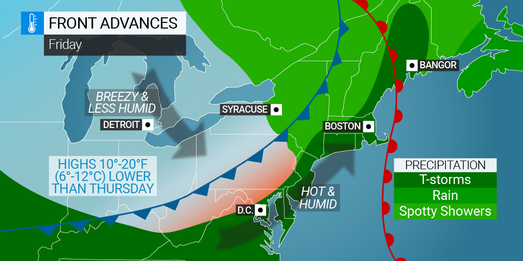
The severe weather and heat has tapered off in this area of the central U.S. However, the storms now have their sights set on the coastal areas of New England and the mid-Atlantic to close out the work week.
The heat that gripped the Midwest early in the week is also moving to the east. While a cooldown is on the way for the weekend for the Northeast, it will be another warm day on Friday with humidity levels that send the real temperature even higher. Most of this area of the U.S. will see temperatures in the 80s and lower 90s.
As this heat continues to build, the necessary fuel will be in place for thunderstorms to erupt just prior to the cold front moving into the region. Forecasters are predicting that there will be enough heat in place to create locally heavy thunderstorms along the busy Interstate 95 corridor and to the east of this highway. This means that the beaches stretching from Virginia up through the Boston area may be under the gun for heavy rain and gusty winds to start the weekend.
While Friday will be another day of warm temperatures, the arrival of the cold front on Saturday will send the mercury plummeting. Daytime highs in some areas will struggle to get out of the 60s and 70s on Saturday. For example, Boston will fall from a forecast high of 85 degrees on Friday to just 67 degrees on Sunday.
The nighttime lows will be even chillier with readings landing in the upper 40s in the higher terrains to the lower 60s along the I-95 corridor. You can expect to see readings in the Northeast over the weekend that are 5 – 10 degrees below average for the middle of June. However, plentiful sunshine after Friday’s stormy activity will make it a pleasant weekend to spend time outdoors.
Did you find this content useful? Feel free to bookmark or to post to your timeline for reference later!

January 21, 2024

January 19, 2024

January 18, 2024
