
Heavy Rain, Flooding, and Chance of Severe Weather Staring Down the Southern U.S.
January 22, 2024
Posted: June 22, 2022 11:52 am


While the bulk of the U.S. has been sweltering under a pervasive heat dome, people living in the Pacific Northwest have been wondering if summer is ever going to arrive. Just in time for the official start of summer, this corner of the U.S. finally got its seasonable weather wish. Meanwhile, the threat of dry lightning strikes is raising the risk of fire danger farther down the coast in California.
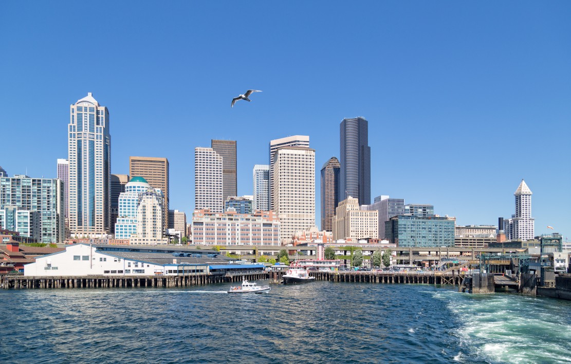
The Pacific Northwest has just wrapped up a spring season that was considerably cooler and wetter than normal. For instance, Seattle has averaged about three degrees below average for June with the Emerald City yet to break the 75-degree mark at all this year. This unseasonably cool weather has stretched as far south as Portland with persistent cloud cover and rain keeping the mercury suppressed.
Both Seattle and Portland have seen about 185% of the typical rainfall amounts for June, pointing to the soggy conditions over the past few weeks. However, a change is on the way with a significant shift in the weather pattern on tap for the region.
After enjoying a beautiful day on Tuesday, the temperatures will fall again slightly for Wednesday and Thursday. A bigger change is in store for the weekend with summerlike conditions on the way.
Over the last few weeks, the area has been kept cool because of a significant bulge in the jet stream set up over the central part of the country. As this bulge loosens its grip and moves to the east, this roadblock to the Pacific Northwest will lift, allowing warmer temperature to finally filter in.
Portland will see highs in the 70s during the middle part of the week transition to readings in the 80s by Friday. The weekend will deliver even hotter readings with temperatures settling in the low 90s for Saturday and Sunday. While this may not seem particularly hot for those in the central U.S., these forecast readings are about 15 degrees above normal for the Rose City for the end of June.
Although it will be warmer in Seattle when compared to the weather of the last few weeks, it will not be as unseasonably hot as what those in Portland can expect. Seattle will climb into the mid-70s by Friday before hitting the low 80s by the weekend. These readings will be about 10 degrees above average for this part of Washington.
The warming trend does not hold a candle to what the Pacific Northwest experienced last year over the last weekend in June. Temperatures soared to up to 30 degrees above normal with Portland and Seattle recording multiple days above the century mark.
California will be under the gun for the development of thunderstorms on Wednesday and Thursday. However, forecasters caution that these storms will not deliver a significant amount of moisture to the drought-stricken state. Instead, the tropical moisture could trigger an increase in wildfires at the hands of dry lighting strikes.
As of the middle of June, almost 98% of the Golden State was under the designation of a severe drought or greater, according to data from the U.S. Drought Monitor. This is the driest period that the western U.S. has seen in at least 1,200 years, leading government officials to enforce water restrictions in many of the hardest-hit areas.
While the bulk of the fire activity in the West has centered over Arizona and Mexico in the early season, California saw a few fires pop up already this week. The Los Angeles Fire Department was called to help contain a brush fire near the iconic Hollywood sign landmark on Monday.
A fire in Redwood City, outside the metro area of San Jose, triggered the evacuations of residents on Tuesday. Over 11,000 customers were without power as a result of this fire. One firefighter had to be taken to a local hospital after suffering injuries trying to get the blaze under control.
Unfortunately for most of California, the window of opportunity for meaningful precipitation has closed for the season. Southern California will see a rare shot for scattered rain on Wednesday throughout the day and overnight hours. However, this chance of rain will disappear as quickly as it came on.
A weak storm system is forecast to drop to the south off of the Pacific Coast. As it does so, it will bring up some of the moisture still left over from Tropical Rainstorm Blas. What was once Category 1 Hurricane Blas is now just a rainstorm hanging out near Baja California.
Although there is a slight chance that some of this rain may find its way into the central and northern parts of California, the greatest chance for any moisture will be in Southern California in cities such as San Diego, Palm Springs, and Los Angeles. Some of the rain may also travel as far to the east as Las Vegas.
Forecasters caution that any rain that this system brings may be negated by the gusty winds and dry lightning strikes that only serve to enhance the wildfire risk.
The rain forecast for Southern California is different from the monsoonal moisture that has been bringing slight relief to areas to the east and through the interior Southwest. New Mexico has been the greatest beneficiary of the start of the North American Monsoon Season with significant rain helping to put out the wildfires that have engulfed the state over the last month.
According to the Southwestern U.S. Coordination Center, over 864,000 acres have burned in New Mexico already this year. This number compares to the total average of 270,000 acres that burn in an entire year. California has been largely spared so far in 2022 with just 17,000 acres scorched this year. However, the California wildfire season does not typically get started until later in the summer.
Did you find this content useful? Feel free to bookmark or to post to your timeline for reference later!

January 21, 2024

January 19, 2024

January 18, 2024
