
Heavy Rain, Flooding, and Chance of Severe Weather Staring Down the Southern U.S.
January 22, 2024
Posted: July 20, 2022 10:17 am


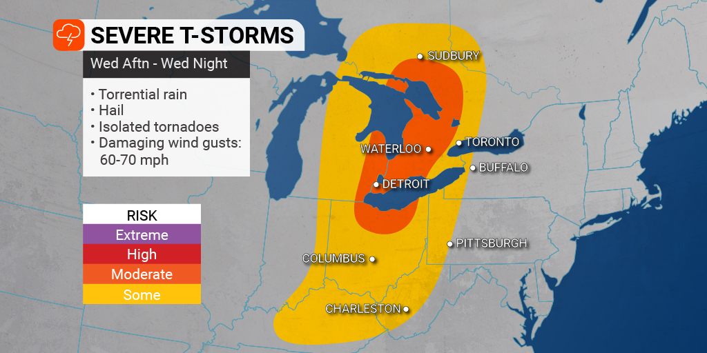
Storms Could Trigger Tornadoes in Great Lakes Region
It will be a week of unsettled weather in the Northeast with several chances of rain and storms potentially disrupting outdoor activities and travel plans in the upcoming days.
The week got off to a rocky start on Monday when flash flooding affected people using the subway system. Some of the stations were flooded when the water came rushing in. It was also a messy day to tour Central Park. The park recorded 1.85 inches of rain for the day. Nearly 0.75 of an inch fell between the hours of 3 pm and 4 pm.
Authorities had to perform water rescues as motorists became stranded in rising waters in New Jersey. As a reminder, motorists should never try to drive through flooded roads. Travelers should also enable smartphone notifications so they can stay informed of rapidly changing conditions.
What was peculiar about Monday’s precipitation event in the Big Apple is that while some suburbs saw over 3 inches of rain, other areas were bone dry. This disparity will be the trend in the days to come with varying amounts of rain throughout the region.

Although Tuesday was mostly dry in the Northeast, a new storm system is poised to make its way around the edge of the heat dome that is anchored over the central U.S. This system is forecast to hit the Northeast by the middle of the week, bringing another chance of rain throughout the area on Wednesday and Thursday. The system will first bring the chance of severe weather to the northern Plains before it pushes to the east.
While the day will start relatively calm on Wednesday, the storms will begin to fire up in the afternoon hours. It will be another scorcher of a day with the heat helping to fuel the development of the storms. Most areas will see temperature readings that climb into the 90s, even as far north as Maine.
The Wednesday storms will first get going in the eastern Great Lakes. These storms will bring the threat of heavy rain, damaging winds, and hail. The most severe cells could even produce isolated tornadoes. The area most likely to see tornadic activity will be the eastern half of Michigan and into southwestern Ontario.
This particular storm system is forecast to meet up with the mass of heat and humidity that is moving up from the South. These forces are expected to clash and trigger the development of strong storms Wednesday afternoon and evening throughout much of Ohio, western Pennsylvania, and eastern portions of Indiana and Michigan.
The biggest risk of Wednesday’s storms will come in the form of straight-line wind gusts that could cause damage. The storms located farther to the north are more likely to get the rotation needed to produce tornadoes. Cities that could see the chance of a tornado include Detroit and Cleveland.
Those individuals heading out on the Great Lakes should keep an eye on any developing weather. It does not take long for calm waters to become choppy and cause issues for boaters.
This rain and stormy weather will push into the coastal areas of the Northeast by Thursday. Unlike Wednesday’s threat, most of the precipitation will fall as straight rain with a lower risk of severe weather. However, the size of this weather maker will bring the precipitation farther to the south when compared to Wednesday’s event. For instance, much of the mid-Atlantic and parts of the Southeast will see a chance of storms Thursday afternoon and evening, including the cities of Atlanta, Charlotte, Raleigh, and Richmond.
Although the unsettled weather will be a hindrance to some, the rain is good news for areas of the Northeast that have been dealing with abnormally dry conditions. The majority of New England is under some level of a drought designation, making this rain important for crops in the region.
Many East Coast cities will be in the crosshairs of flash flooding as these storms rumble through the region on Thursday. This includes New York City, Philadelphia, and Boston.
The weekend is shaping up to be drier as the storm system moves out into the Atlantic Ocean by Friday.
Did you find this content useful? Feel free to bookmark or to post to your timeline for reference later!

January 21, 2024

January 19, 2024

January 18, 2024
