
Heavy Rain, Flooding, and Chance of Severe Weather Staring Down the Southern U.S.
January 22, 2024
Posted: July 22, 2022 10:31 am


Cold Front Will Bring Chance of Stormy Conditions to I-95 Corridor Early Next Week
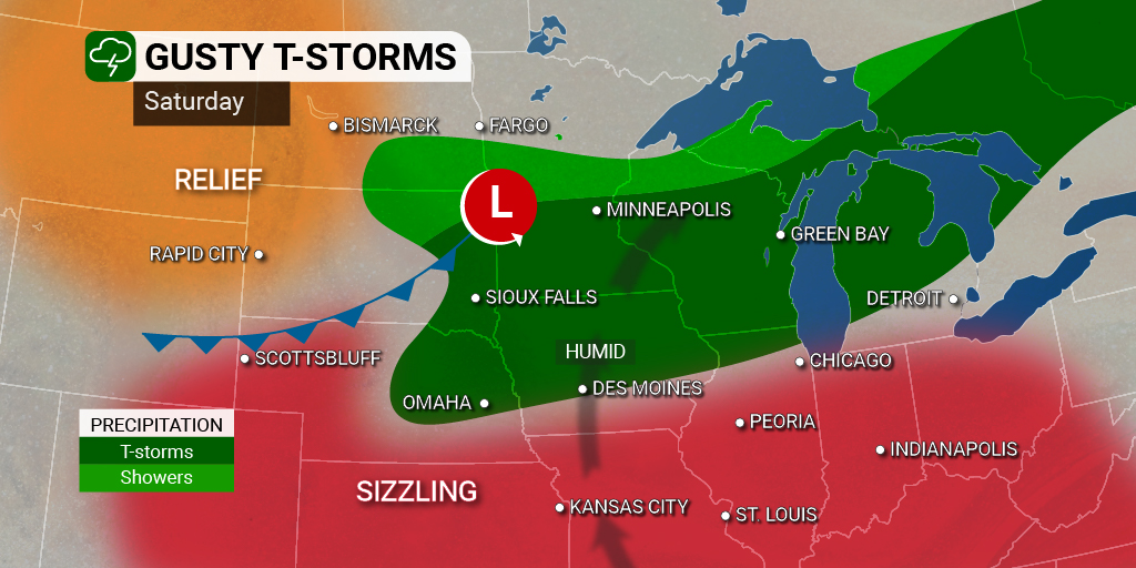
While the heat has been rightfully dominating the weather headlines across the U.S. as of late, forecasters are warning that parts of the Upper Midwest may be under the gun for a severe thunderstorm outbreak on Saturday.
The necessary ingredients are forecast to be in place in the atmosphere on Saturday to trigger these strong storms. The storms are expected to fire up in the early afternoon hours starting in central Minnesota through northern Wisconsin. The Twin Cities will be in the crosshairs of this development, however, forecasters believe this early round of storms will not be as severe.
For example, Minneapolis is predicted to be under mostly cloudy skies for the day with a good chance of storms by the afternoon. The area will see a muggy high in the mid-80s.
The line of storms is forecast to pick up energy as it moves to the south and to the east, bringing greater dangers to those in this path. As the storms grow in size and power, there is the possibility that isolated tornadoes may spin up. The biggest risk of tornadic activity will happen at the initial stages of the storms.
Wind shear is another factor in the formation of tornados. This meteorological element is defined as the change in the speed and direction of winds located in various levels of the atmosphere. If the winds move direction while also increasing in speed close to the ground, it gives thunderstorm cells the ability to rotate at a greater degree. This translates to a greater chance of tornados and strong winds coming out of a particular storm cell.
In addition to the damaging winds and tornadoes, Saturday’s stormy activity may also carry the risk of hail and heavy rains. The amount of moisture predicted with this weather maker could trigger flash flooding across the region.
Although one storm may have enough associated precipitation to bring heavy rain to the area, the risk for flash flooding will increase if more than one storm moves through an area.
This expected line of storms will move to the east through the afternoon and evening hours. Forecasters are still uncertain just how far to the south the storms will drop. However, it appears that cities such as Madison, Wisconsin and Milwaukee will be in the heart of the impact zone. The college town of Madison will see a mix of sun and clouds throughout the day with a high of 90 degrees.
There is also an outside possibility that the storms will expand far enough south to bring the inclement conditions to Chicago and the outlying suburbs. As of now, Chicago is forecast to see a small chance of isolated thunderstorms in the morning hours with partly cloudy conditions to end the day. The Windy City will reach a high of about 90 degrees for the day.
The storms will eventually move across Lake Michigan and into Michigan’s lower peninsula in the overnight hours, including the city of Detroit. If you live in this area, be sure to enable your smartphone weather notifications in the overnight hours. Storms are typically more dangerous when they form overnight when most people are sleeping and unaware of the developing conditions.
Heading into Sunday, areas of western New York headed down into the northwestern corner of Pennsylvania may see thunderstorms accompanied by a great amount of precipitation thanks to a cold front moving down from Canada. Places such as Syracuse, New York are forecast to see about a 50% chance of thunderstorms in the afternoon hours with a high in the low 90s.
This rain may move into Ohio, Indiana, and Illinois by the end of the weekend. For instance, Indianapolis will be under the gun for scattered afternoon storms to close out the weekend. You can expect the mercury to climb into the mid-90s, making for a steamy day.
Elsewhere in the region, Cleveland will also see a good chance of storms later in the day. Some of these storms may be severe in nature. The high will approach 90 degrees, particularly when the sun is shining.
The cold front is predicted to reach parts of the Interstate 95 corridor by early in the work week, bringing the chance of storms to some of the most populated cities of the East Coast by Monday. Be sure to check back on the forecast to see how this develops in the coming days.
Did you find this content useful? Feel free to bookmark or to post to your timeline for reference later!

January 21, 2024

January 19, 2024

January 18, 2024
