
Heavy Rain, Flooding, and Chance of Severe Weather Staring Down the Southern U.S.
January 22, 2024
Posted: September 6, 2021 12:06 am


As a Category 3 storm, Hurricane Larry continues to strengthen in the Atlantic. This storm will likely pass within a few hundred miles of Bermuda before hitting Atlantic Canada.
Although Hurricane Larry is not likely to make a direct hit on the US, the impacts from this large and powerful storm system could be felt up and down the East Coast throughout next week.
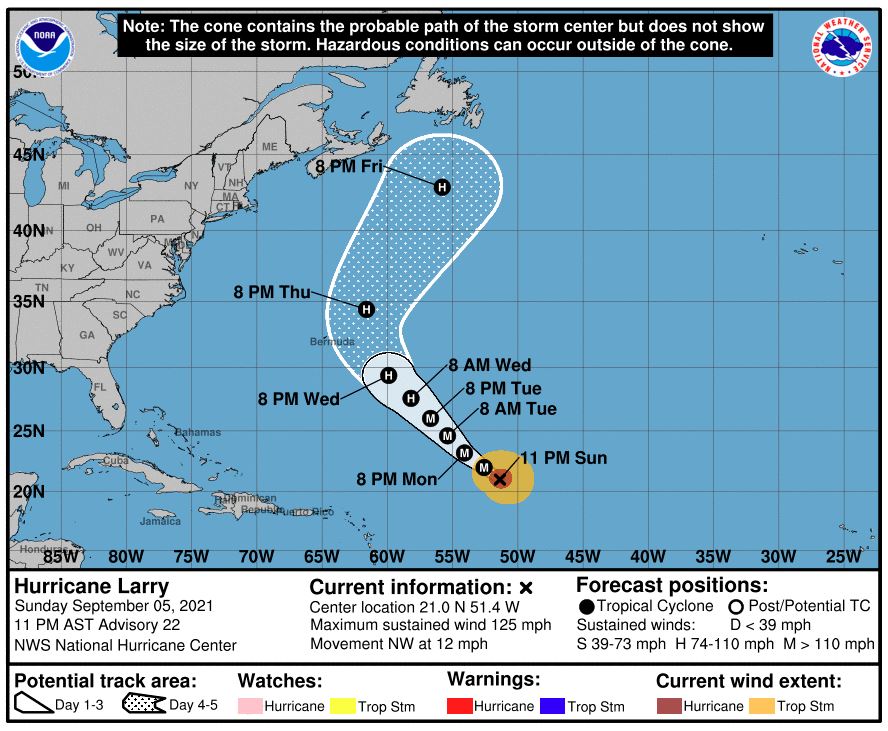
As of mid-day Sunday, Larry was a Category 3 hurricane spinning out in the Atlantic basin. The storm is currently boasting maximum sustained winds of 125 mph as it moves to the northwest at a speed of 13 mph. Larry is located about 1,200 miles from Bermuda.
Forecasters at the National Hurricane Center (NHC) predict that Larry will strengthen into a Category 4 storm packing winds of 130 to 156 mph. As Larry moves through the warmer ocean waters, wind shear conditions will be favorable for more development.
Larry’s track is expected to take it well east of the coastal US. However, because it is so large in size, its impacts may be felt along coastal areas stretching from Florida into Maine. The current trajectory will likely take Larry close to Bermuda before a potential landfall in Atlantic Canada.
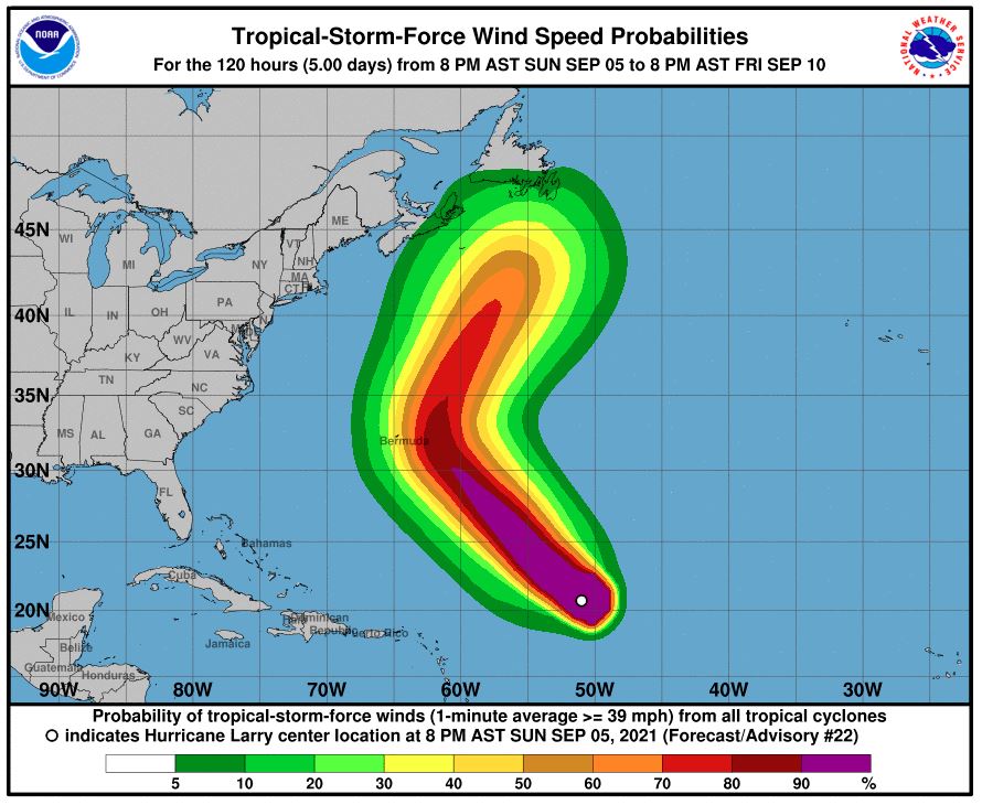
Tropical-storm-force winds of 39 mph or stronger are expanding out from the center of Larry by 140 miles. This means that it does not have to make a direct landfall to deliver significant impacts. Larry is forecast to move to the northwest and north this week, bringing along large ocean swells through the Caribbean. These swells will come in advance of the hurricane’s arrival into the area. There are already swells along the southern coastline of Bermuda and the northeast-facing coastal areas of some islands in the Caribbean.
The swells will spread through the Bahamas beginning on Monday and continuing through Tuesday. This action will then reach the US coastline by the middle of the week. It is not unusual for these swells to form rip currents as they build up. As such, swimmers are cautioned to follow the restrictions that have been put into place at their local beaches as summer comes to an end.
While it is still too early to predict with certainty, it is likely that Larry will come within a few hundred miles of a brush with Bermuda. Should this happen, it would likely occur on Thursday. The current models show that the center of Larry would pass about 150 miles to the east of Bermuda.
However, even if Bermuda does not take a direct hit, the surf and rough seas will make their presence known during the middle of the week. In addition, the area will likely see tropical-storm-force wind gusts ranging between 40 and 70 mph as Larry is expected to pick up strength in the coming days. While major structural damage is unlikely due to the strong infrastructure of Bermuda, it is possible that the region may experience power outages.
Bermuda is currently forecast to pick up one to two inches of rain as a result of Larry.
If Larry moves farther to the west, the islands of Bermuda will see a more significant impact. However, a track farther to the east will lessen the impacts.
Larry is not expected to make a direct hit on the US. If it continues with its projected track, it is likely that it will remain a hurricane as it trudges through the North Atlantic despite the decrease in ocean water temperatures. Most models show Larry making a hit on Atlantic Canada as either a minor hurricane or a strong tropical storm.
This would bring wind speeds in the range of 74 – 95 mph along with heavy rain.
Atlantic Canada is generally spared the brunt of major hurricanes. However, its location makes it a likely target for tropical rainstorms as they burn out over the cooler waters of this part of the Atlantic. In 2020, Nova Scotia experienced the wrath of Teddy as a 65-mph tropical rainstorm. Going back one more year, Dorian made a direct hit on Nova Scotia as a tropical rainstorm packing hurricane-force winds.
Hurricane Igor was the last of its kind to make landfall on Atlantic Canada. Igor hit as a Category 1 storm in Newfoundland in September of 2010. Just days prior to that, Earl made landfall in Nova Scotia as a Category 1 hurricane.

January 21, 2024

January 19, 2024

January 18, 2024
