
Heavy Rain, Flooding, and Chance of Severe Weather Staring Down the Southern U.S.
January 22, 2024
Posted: February 23, 2022 5:39 pm


If you live on the East Coast, you better get out and enjoy the warmth on Wednesday while you can. This springlike warmth is set to disappear by Thursday, bringing a return to winter weather.
It will be another beautiful day in the Northeast on Wednesday as warm air moves in from the Ohio Valley and into the Atlantic coastal regions. Temperatures are forecast to hit the middle 60s for cities such as Boston and New York City. It will be even warmer in Philadelphia and Washington, D.C. with the mercury readings expected to soar close to 70 degrees. While these readings will not likely break any records, it will certainly not feel like February for the region.
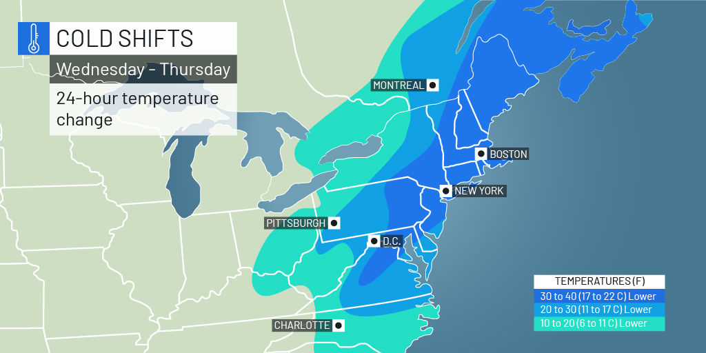
A dramatic cool down is on tap for Thursday as frigid air is predicted to dive down from Canada and the Great Lakes region. This mass of cold air will envelop the entirety of the Northeast by the time that it is in place. The bitterly cold air will feel more like the dead of winter as opposed to the end of the season.
Some areas will experience a temperature shift by as much as 40 degrees in a time period of just 24 hours. The cold will stretch from the interior of Maine all the way down into the Carolinas.
Temperatures will barely hit the 30s in cities such as Boston on Thursday. By Friday night, the lows will plummet into the teens. The coldest areas of northern New England will see overnight lows on Friday in the single digits.
The cold will expand into the mid-Atlantic region as the mass pushes forward. While the temperature changes will not be as sharp, it will still be a noticeable cool down. For example, Richmond, Virginia will struggle to get out of the mid 40s on Thursday after seeing temperatures near 70 degrees on Wednesday.
It is easy to think that these temperatures are far below normal. The reality is that these readings are fairly average for this time of the year. It will simply seem so much colder on the heels of the unseasonably warm weather.
Along with the cold air, this new weather system will also bring the high probability of wintry precipitation. The second of two cross-country storms is moving into the East beginning late Thursday and into Friday.
Snow and ice will be the story on Thursday in Michigan and Ohio. This system will eventually move into the Northeast on Friday. Several inches of snow will fall in the hardest hit areas.
The area will begin to dry out over the weekend and into the early part of next week before a more active weather pattern sets up again.

January 21, 2024

January 19, 2024

January 18, 2024
