
Heavy Rain, Flooding, and Chance of Severe Weather Staring Down the Southern U.S.
January 22, 2024
Posted: April 13, 2021 3:54 pm


The weather whiplash continues for much of the country, causing some people to have to double-check their calendar to see what month it is.
Arctic Air to Bring Weather Changes: While the Plains have been enjoying weather that resembles late spring more than early spring, that is all about to change when a blast of Arctic air makes its way into the region, stretching as far south as northern Oklahoma and northern New Mexico.
Dramatic Change in Temperatures: Over the last few days, much of the central portion of the US has been enjoying temperatures that have been far above normal. Cities such as Denver and Colorado Springs saw the mercury rise to near 80 degrees. However, the incoming cold air mass will send these temperatures plummeting, bringing along the chance of wintry precipitation in the process.
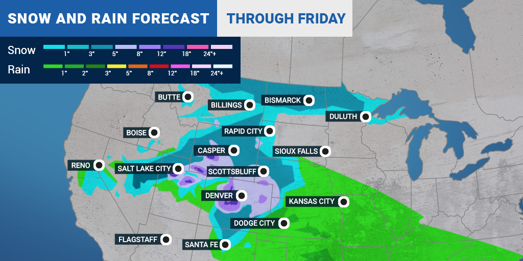
Wintry Precipitation to Begin Late Monday: The wintry precipitation will fire up in the northern Plains on Monday night and is expected to continue throughout the following day and night. Fargo and Bismarck, North Dakota, will be the first US cities to pick up measurable snow as the system advances to the south and east throughout the week.
Along with the snow, winds are also anticipated to pick up. These gusty conditions will drop the mercury even further while also raising the potential of blowing snow. Motorists traveling along Interstate 90 in South Dakota need to be prepared for high winds, elevated brush fire risk, and blowing dust as the winds pick up.
Rocky Mountain Region Up Next for Snow: A new system will move into the High Plains and Rocky Mountain region by late Tuesday. The snow will first fall heavily in the higher elevations of the mountains. However, by Wednesday, the snow will likely drop down into the Front Range, bringing measurable precipitation to Denver, Colorado Springs, Cheyenne, and more.
The busy Interstate 25 corridor through Colorado and into Wyoming could be in for a messy commute on Thursday morning. The snow is predicted to trek to the east during the day on Thursday. It is possible that the drought-stricken Black Hills of South Dakota may pick up some snow out of this late-season system.
Temperatures Below Normal: As expected, temperatures will be well below normal as the April snow expands. The cold push of Arctic air will affect cities as far south and east as Kansas City, Wichita, and Oklahoma City. This cooler than average air is expected to stick around through the end of the weekend, potentially hampering the plans of many to get out there and start planting and gardening.
The good news is that this late blast of winter will delay the possibility of severe thunderstorms and tornadic activity firing up as is typical for this time of the year.

January 21, 2024

January 19, 2024

January 18, 2024
