
Heavy Rain, Flooding, and Chance of Severe Weather Staring Down the Southern U.S.
January 22, 2024
Posted: August 12, 2021 5:11 pm


Meteorologists are warning that while what was once Tropical Storm Fred is now a tropical depression, the system is likely to strengthen once again as it meanders around the warm waters of the eastern Gulf of Mexico.
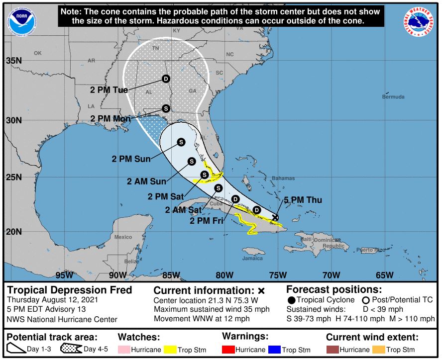
As of Thursday morning, Fred was located about 230 miles east of Camaguey, Cuba. Fred was packing maximum sustained winds of 35 mph, down about 10 mph from the previous day. The storm was moving at a clip of 14 mph to the west and northwest.
Haiti, the southeastern Bahamas, and some parts of Cuba are still under tropical storm watches despite the weakening of Fred when it reached Hispaniola. Although the exact track of the storm is not perfectly clear at this point, forecasters at the National Hurricane Center (NHC) are predicting that Fred could potentially make two landfalls in the US. The first landfall would potentially hit the Florida Keys on early Saturday. The second landfall could come onshore along the coast of northern Florida by early next week.
Fred may encounter some issues continuing on its path. The system experienced weakening as it moved over the higher terrain of Hispaniola on Wednesday. Dry air hanging out over the Greater Antilles may serve to further weaken this storm. The current forecast predicts that Fred may slow strengthen as it skirts along the coast of Cuba.
Fred is on track to begin the intensification process late in the day Friday. This strengthening may not come to fruition if Fred makes a turn to move over the island of Cuba. However, there is also still a chance that Fred could encounter the environmental conditions necessary to power a jump to hurricane status when it reaches the Gulf of Mexico.
This is the time of the year when the waters in the Gulf of Mexico are more conducive for tropical storm intensification. The water temperature surrounding Key West, Florida was a steamy 88.5 degrees on Thursday, providing the impetus needed for Fred to reorganize when it reaches this area.
Any area affected by Fred’s path should be ready for heavy rainfall and potential flooding. The risk of flooding will be even higher if Fred stalls out over the southeastern US.
The earliest signs of Fred could begin in parts of South Florida and the Keys by Friday afternoon. The persistent rainfall and strong winds will spread across the Florida peninsula through the weekend, eventually making their way into the southeastern US by late Sunday and early Monday. The arrival of the outer bands will also bring the threat of waterspouts and tornadoes.
Wind will undoubtedly be a factor with Fred. Wind gusts reaching 40-60 mph may make their mark on the Florida Keys by Friday evening. These winds could reach Southwest Florida by sunrise on Saturday. The strong gusts will likely expand to the north throughout the weekend, affecting the Florida Panhandle by the end of the weekend.
The strongest winds will happen to the east of where Fred eventually moves onto land. At this time, this second landfall is expected to occur over the central or eastern edge of the Florida Panhandle. However, this trajectory could change depending on the steering winds that Fred encounters as it moves into the Gulf.
The gusts in the most heavily affected areas could reach up to 80 mph. Winds of this magnitude would likely cause power outages and property damage.
In addition to Fred, forecasters are keeping an eye on a small area of low pressure that has taken root along a tropical wave. This feature is currently located approximately 1200 miles east of the Lesser Antilles. While the low does not have a closed center of circulation, it is producing a good amount of showers and thunderstorms.
At this point, the NHC predicts that the environmental conditions in its path will provide the fuel for further development over the next few days. Most models show that a tropical depression will form over the weekend as the feature moves to the west across the Atlantic at a fast clip of about 20 mph.
The feature will likely reach the Leeward Islands by late Saturday or early Sunday. The NHC has the odds of the system reaching a tropical depression at 60% over the next 48 hours and 70% over the next five days.

January 21, 2024

January 19, 2024

January 18, 2024
