
Heavy Rain, Flooding, and Chance of Severe Weather Staring Down the Southern U.S.
January 22, 2024
Posted: September 25, 2021 2:52 pm


Subtropical Depression Teresa Could Impact Atlantic Canada
What was once Tropical Storm Sam is now Hurricane Sam as the tropical feature continues to rapidly intensify. Forecasters at the National Hurricane Center (NHC) are predicting that this feature may end up as a Category 4 storm by the end of this weekend.
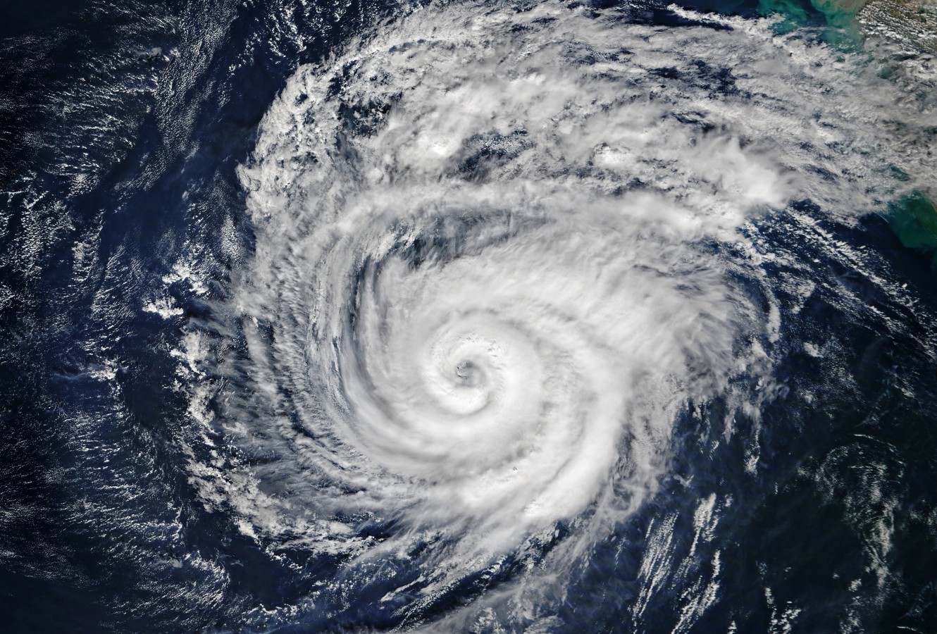
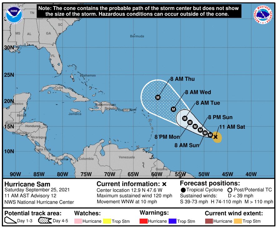
As the seventh hurricane of the 2021 Atlantic season, Sam is now a Category 3 storm with maximum sustained winds of 120 mph. The storm is positioned 1095 miles east-southeast of the Northern Leeward Islands as of Saturday afternoon as it moves to the west and northwest at a speed of 10 mph. While the track of Hurricane Sam will depend on steering winds it will encounter later this week, there is the possibility that the storm could veer toward the US by the first few days of October.
It did not take long for Sam to ramp up. Sam became a Category 1 hurricane with top wind speeds of 75 mph on Friday morning. Just 24 hours earlier, it was only featuring winds around 35 mph. Sam turned into a Category 2 hurricane by early Saturday morning before inching up to the Category 3 designation a few hours later.
Looking at the storm from satellite images, forecasters point to a number of high-level clouds that represent a strong outflow. This outflow is often seen in hurricanes that are positioned to strengthen quickly. The counter-clockwise movement of the clouds is also a sign that this particular hurricane has the ingredients needed to continue to grow in size and intensity.
Sam is forecast to pump out large swells that will move out from the center of the storm. These swells will be responsible for massive waves and rough surf conditions along the eastern and northeastern facing shores of the Leeward Islands. Despite the track of the storm predicted to turn to the north at some point, Sam may still bring significant impacts to this group of remote islands.
The timing of the turn to the north will largely affect how much of a blow the storm brings to the Leeward Islands. If Sam starts to make the turn sooner rather than later, the group of islands will avoid the worst of the storm and its eyewall. At the very least, the islands will experience heavy rain and strong winds from the outer bands of the storm.
However, a later track to the north by Sam could deliver the threat of much more significant impacts to the islands. This includes the chance of coastal erosion, flooding rainfall, and destructive winds.
Should Sam continue along a west and northwest trajectory, it would come closer to approaching the US. This path will be determined by the weather pattern influences in North America. For example, if the jet stream dips to the south, Sam will be more likely to move away from the US. But if the jet stream positions itself farther to the west, Sam may inch closer to making an impact with US coastal areas by next weekend.
Other areas in line to experience the effects of Sam could be the islands of Bermuda or Atlantic Canada.
Rough seas and surf will set in as early as the middle of this coming week along the southeastern coast of the US. The impacts will drift farther to the north as the weekend approaches.
In addition to Hurricane Sam, forecasters are also monitoring the newly formed Subtropical Storm Teresa. This feature formed late Friday afternoon about 155 miles to the north and northwest of Bermuda. As of Saturday morning, Teresa was featuring maximum winds of 35 mph as it churns about 140 miles north of the Bermuda islands.
While Teresa will not threaten the US, the storm could impact Atlantic Canada over the coming days. Nova Scotia and New Brunswick may see persistent rainfall and the chance of localized flooding as the system inches closer.
Teresa is distinguished as the 19th named storm in the Atlantic this year. Victor and Wanda are the last two remaining names for the season. Should this list be exhausted, a supplemental list of names produced by the World Meteorological Organization will be used for additional storms.

January 21, 2024

January 19, 2024

January 18, 2024
