
Heavy Rain, Flooding, and Chance of Severe Weather Staring Down the Southern U.S.
January 22, 2024
Posted: June 3, 2022 3:15 pm


Tropical Weather Event May Impact Eastern Seaboard by Sunday
The rain has already started falling in Florida as the Sunshine State prepares for what could be its first named storm of the 2022 Atlantic season.
Tropical storm warnings are in effect for South Florida, including populated areas such as Miami, West Palm Beach, Fort Lauderdale, Naples, and Key West. While the National Hurricane Center (NHC) initially issued a tropical storm watch on Thursday, this was quickly upgraded to a warning by the end of the day. The storm system is forecast to bring heavy rain and damaging winds through at least Saturday for the bulk of South Florida.
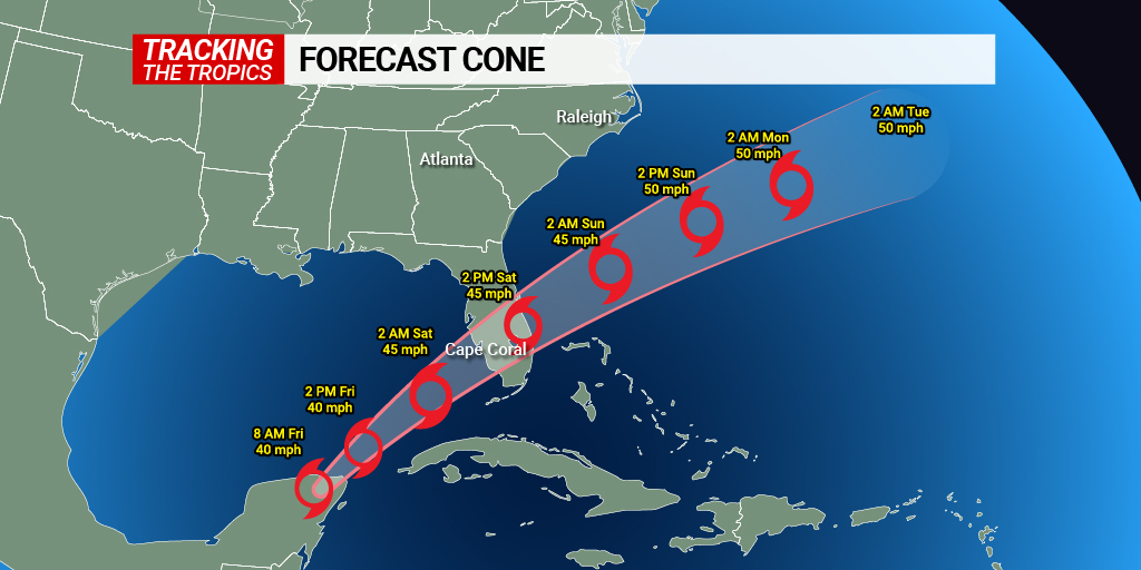
As of Friday morning, the system was positioned about 400 miles to the southwest of Fort Myers. Forecasters are predicting that the weather maker will continue to intensify in the coming hours and develop into an official tropical storm before it hits the coast of Southwest Florida early Saturday. Should this happen, the storm would be named Alex.
While the maximum sustained winds circulating with the system are currently above the tropical storm threshold of 39 mph, the hurricane hunter aircraft investigating the conditions have not found a closed area of circulation.
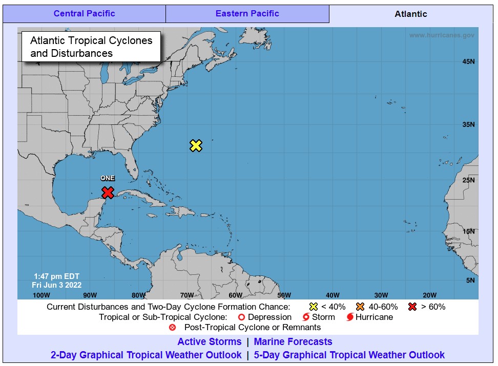
The NHC gave the weather system the designation of Invest 91L on Wednesday after it started to strengthen in the northwestern Caribbean Sea. The area of low pressure was a result of the remnants of what was once Category 2 Hurricane Agatha over Mexico. After slamming into the coast of southern Mexico, Agatha moved across the region before re-emerging in the waters off of the Yucatan Peninsula.
Forecasters are predicting that the wind shear currently in place over the Gulf of Mexico will begin to weaken on Friday. This will allow Invest 91L to further develop. In addition, the cluster of stormy activity will also encounter warmer ocean waters, helping to spur its intensification.
Current water temperatures in the path of the Invest 91L are hanging out in the 80s. These readings are well above the recognized threshold of 77 degrees for tropical development.
Even if Invest 91L does not reach tropical storm status, there is no doubt that much of Florida is in for a messy start to the weekend. A large zone stretching from the Florida Keys through the Everglades and into the Miami metropolitan area is predicted to see 8 – 12 inches of rain out of this system. Because this rain will fall in a short 24-hour period, flash flooding will be a concern through the weekend. It will not be surprising if the hardest-hit areas record rainfall of up to three inches per hour.
Western Cuba is also forecast to see a significant amount of rain, ranging from 4 – 8 inches. This amount of precipitation will bring the risk of mudslide over the mountainous terrain of this island nation. The storm will then move on to the northwestern Bahamas by early Saturday, bringing rain and thunderstorms.
Although some areas of South Florida will welcome the rain after dealing with abnormally dry conditions this spring, too much rain falling at this fast of a clip is never a good situation. Residents need to be prepared to adjust travel plans this weekend if roads become flooded.
Despite heavy rain being the chief concern of this system, there is also the risk of minor coastal flooding and rough surf conditions through Florida. A rapidly intensifying storm can also spark tornadoes and waterspouts.
Hurricane experts are warning that the storm could take on tropical characteristics once again as it moves to the northeast over the Atlantic Ocean late in the weekend and into next week. This path could bring impacts to the Eastern Seaboard. Beach communities such as Myrtle Beach and Virginia Beach need to be prepared for minor coastal flooding, beach erosion, and strong rip currents beginning Sunday and continuing through Tuesday.
The weekend is not expected to be a total loss in Florida. Conditions will begin to improve in Southwest Florida by late Saturday afternoon as the rain shifts to the east. The rest of the peninsula will see improvement by Sunday. The mercury will climb into the 90s by the time the sun comes out on Sunday.
Sharing is caring! Did you find this content useful? Feel free to bookmark or post this article to your timeline for reference later!

January 21, 2024

January 19, 2024

January 18, 2024
