Heavy Rain, Flooding, and Chance of Severe Weather Staring Down the Southern U.S.
January 22, 2024
Posted: June 15, 2022 12:28 pm


Tropical Storm Blas Forms in East Pacific
Is the tropical activity finally firing up in the Caribbean Sea? Forecasters are keeping a close eye on this part of the Atlantic basin as a potential tropical development may be on the horizon. Meanwhile, there is now an official tropical storm meandering through the East Pacific. Here is the latest on the 2022 hurricane season.
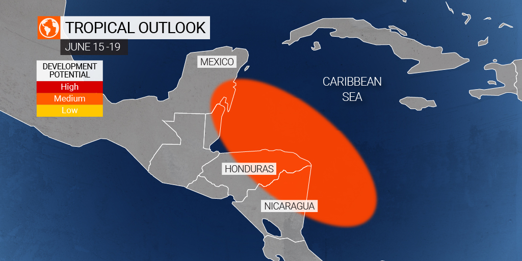
Hurricane watchers are monitoring a zone of clouds and thunderstorms that is moving across the western Caribbean, keeping an eye out for signs that these pockets would develop into a tropical feature later in the week. The storms are currently taking aim at parts of Central America, however, it is unlikely that the system develops into a named feature until late in the week.
The Saharan dust plume moving through the tropical Atlantic is doing more than just providing colorful sunsets to the region. This dust is also inhibiting the development of tropical storms in its path, suppressing the start of the Atlantic hurricane season. However, this dust is forecast to lessen in areas of the southwest Caribbean for a short time on Thursday and Friday. Should this happen as predicted, there will be a small window of time for the area of activity to intensify into some greater.
The current forecast is predicting that this area of thunderstorm activity will ignite and track around the southern Caribbean by the middle of the week. An area of low pressure is forecast to form and organize by the end of the week. Forecasters are also predicting that an influx of moisture and low wind shear levels will help to contribute to the odds that a tropical development forms in the coming days.
According to the Ocean Prediction Center, sea-surface temperatures in the western Caribbean are currently measuring about 86 degrees. This reading is well above the recognized threshold for tropical development of 79 degrees.
Should this feature develop, the worst of the winds will first start up along the coastal areas of eastern Honduras and Nicaragua. The mostly likely time frame for this development would be Thursday or Friday. There is also the potential of rough seas across a large portion of the western Caribbean Sea.
It has been a relatively quiet start to the 2022 Atlantic hurricane season. The first named storm of the year formed on June 5 when Tropical Storm Alex moved off the coast of Florida and intensified in the warm waters near the Bahamas. The next name up on the list of predetermined names is Bonnie.
The westward to northwestward steering patterns currently in place in the upper levels of the atmosphere would likely guide any potential storm this week along a different path than Tropical Storm Alex saw. It is most likely that any storm would track towards Central America, southern Mexico, or the Texas Gulf Coast. Florida would most likely be spared any direct impacts this time around.
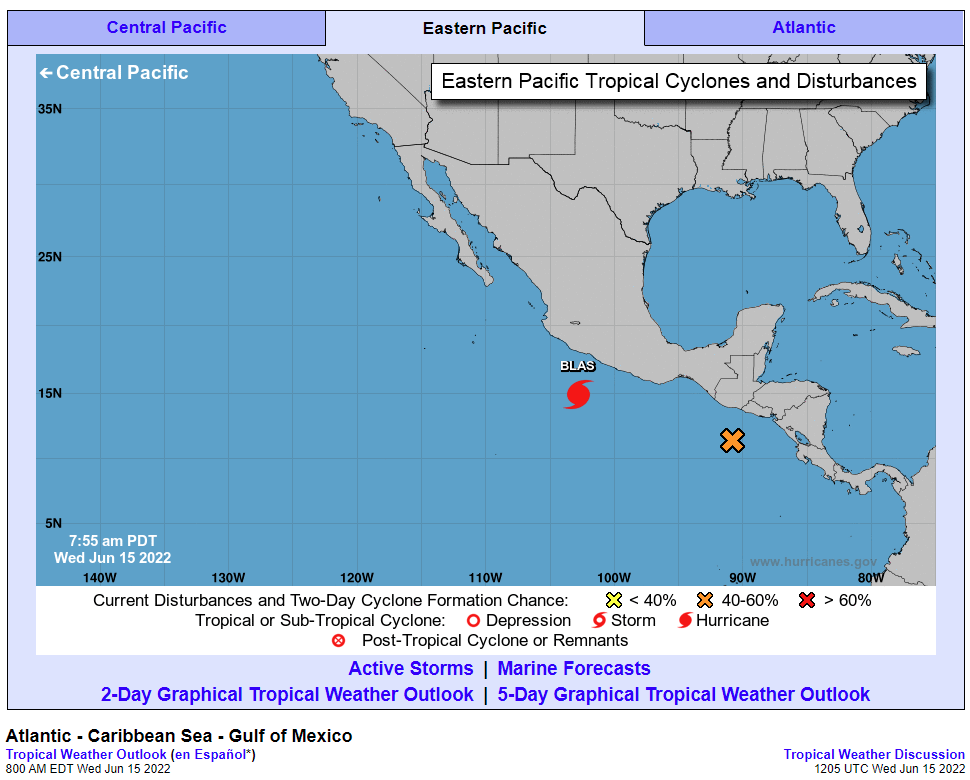
The East Pacific has seen more action so far this season with another tropical storm forming early Tuesday. The National Hurricane Center (NHC) upgraded Tropical Depression 2-E to Tropical Storm Blas at about 11 am EDT.

Forecasters are predicting that the storm will intensify in the coming days, possibly reaching hurricane status by late Wednesday or early Thursday. The current path takes it to the northwest, running parallel to the southwest coast of Mexico. It is not expected that any major land masses will take a direct hit. However, the southwestern coast of Mexico should be ready for an increase in heavy rain as well as strong rip currents and dangerous surf conditions.
The storm is forecast to weaken once it reaches the cooler waters of the Pacific later in the weekend. The presence of the storm may deliver more moisture to kick off the start of the North American monsoon season in the Desert Southwest.
Did you find this content useful? Feel free to bookmark or to post to your timeline for reference later!

January 21, 2024

January 19, 2024

January 18, 2024