Heavy Rain, Flooding, and Chance of Severe Weather Staring Down the Southern U.S.
January 22, 2024
Posted: February 26, 2021 3:17 pm


The Midwest and the Northeast are preparing for the potential of another sloppy weekend as a pair of winter storms creeps into the region.
One-two Punch on Tap: While the storms moving into the many areas of the nation will not pack quite the punch as the weather that previously pounded the region this winter, they still carry the potential of disrupting travel and causing moderate headaches this last weekend of February. Forecasters are warning those in the path to be prepared for moderate snowfall or a thin coating of ice, causing issues for motorists.
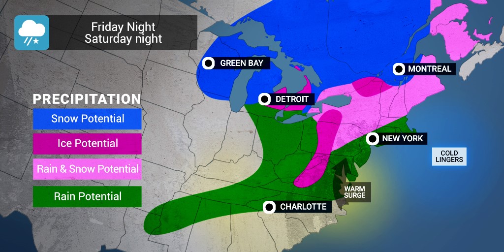
First System Gearing Up: The first system will move into the northern tier of the nation on Friday night and into Saturday. The Great Lakes and New England stand the most chance of seeing accumulating snowfall to kick off the weekend. The areas most likely to see significant snowfall include the higher terrains of Vermont and New Hampshire, northern Maine, Upstate New York, and the northern swath of land stretching through Michigan, Wisconsin, and Minnesota.
Ice in the Southern and Central Appalachians: A little farther south, it will be the ice that is the story. A wedge of cold air has set up over the central and southern Appalachians that will enable a short burst of potential freezing rain and icy conditions. The mountain ranges along the border of West Virginia and Virginia are at risk of seeing up to 0.25 of an inch of ice to accumulate, raising the risk of treacherous road conditions and power outages.
The higher terrains of central Maryland and central Pennsylvania may also see a slight accumulation of ice. The roads most likely to be affected by this ice include the Pennsylvania Turnpike, the Massachusetts Turnpike, and interstates 68, 78, 80, 81, and 99. This ice will begin to show up late Friday.
Rain and Wet Snow for Coastal Areas and Ohio Valley: In the absence of the bitterly cold temperatures of a few weeks ago, a large area of the Ohio Valley and coastal regions of the I-95 corridor will only see precipitation in the form of rain or wet snow. The city of New York may see wet snow or rain early Saturday morning.
This wet snow and rain mix will also stretch south into Philadelphia, Baltimore, and Washington DC starting late Friday night and continuing through the Saturday morning hours. Boston and its suburbs will see this same wet snow and rain potential throughout the day on Saturday.
Midwest Precipitation: Over in the Midwest, areas of central Michigan and southern Wisconsin are likely to see a small amount of wet snowfall overnight Friday. While the cities of Chicago and Detroit are not expected to see significant snowfall, there is the potential of a coating of ice by the time the system moves through Saturday morning. The temperatures during the time that the precipitation picks up will dictate if it falls as wet snow or simply rain.
Second Storm to Hit Late Saturday: The second of the pair of storms is expected to begin making its presence known on late Saturday night and into Sunday. Because this system will not have as much cold air to draw upon, it is predicted to be the milder of the two weekend storms. The storm will set up over the Ohio Valley and move through the mid-Atlantic by the end of the weekend. Most areas should expect to see only rain or drizzle as a result of the weak system. A lack of moisture will keep the chances of winter precipitation minimal.
Fog a Primary Concern: Forecasters warn that one of the biggest concerns of the weekend for the northern tier of the nation and stretching into the mid-Atlantic is the potential for dangerous fog. This is likely to happen as the mild and moist air passes over snow cover. The fog may also set up between the two storms, particularly if the skies clear in between the separate systems.

January 21, 2024

January 19, 2024

January 18, 2024