
Heavy Rain, Flooding, and Chance of Severe Weather Staring Down the Southern U.S.
January 22, 2024
Posted: September 7, 2022 10:58 am


Hurricane Kay Could Bring Moisture to Southern California and Southwest
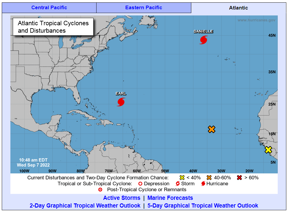
With the climatological peak of the 2022 Atlantic hurricane season right around the corner, the tropics are right on schedule with an increase in the amount of activity. The newly formed Tropical Storm Earl is now on track to become the first major hurricane of the year in the coming days. Here is what is happening in the Atlantic Basin as well as a peak at the activity currently going on in the East Pacific.
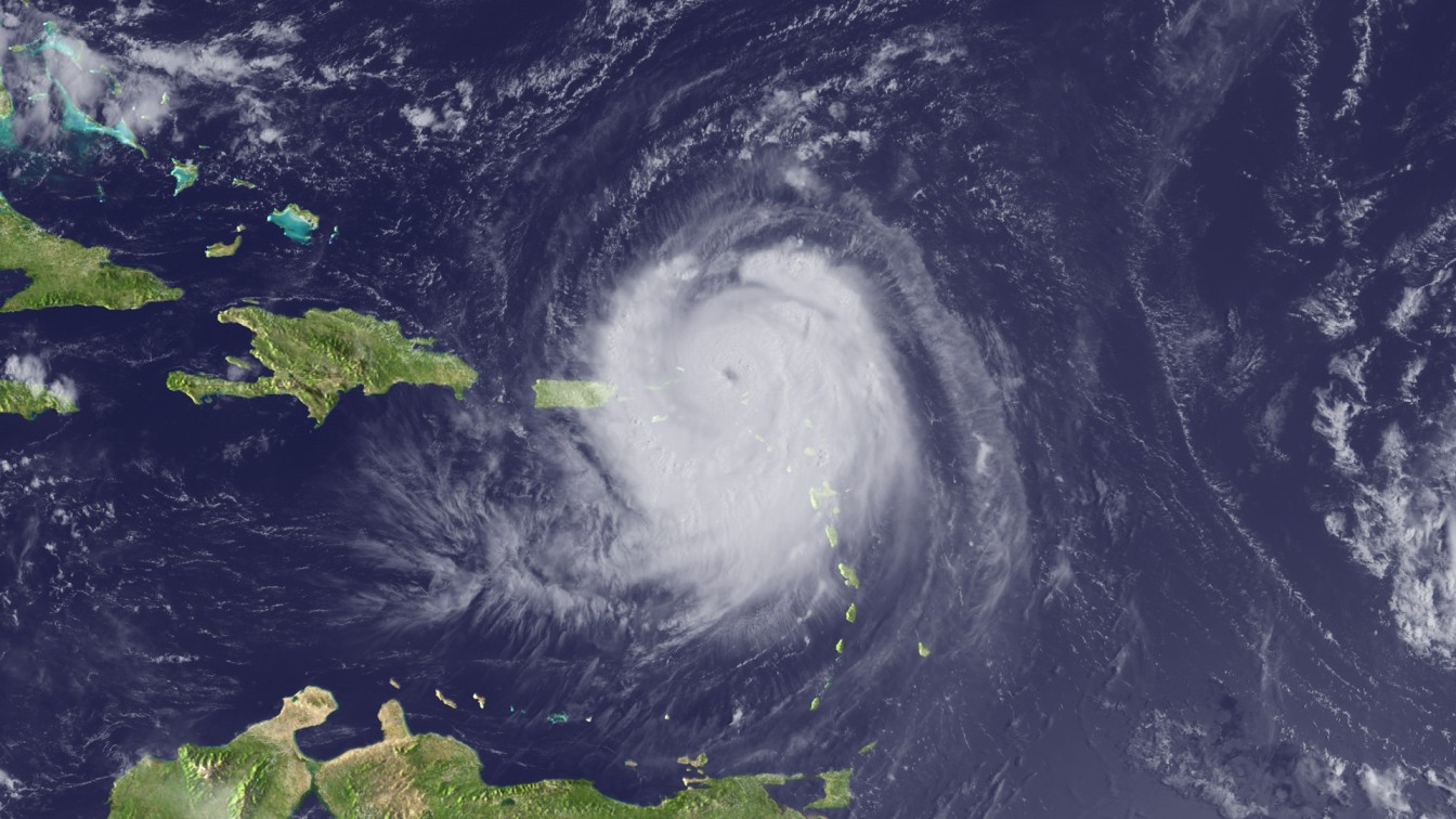
Although Tropical Storm Earl initially formed on September 2, an abundance of wind shear prevented it from strengthening at a normal speed. However, the storm was able to find the conditions that it needs to grow and intensify early this week. As of Tuesday, it was boasting maximum sustained wind speeds of 65 mph. The storm is forecast to evolve into a hurricane by Wednesday, reaching the designation of a major storm by the end of the week. A hurricane is given the designation of a major storm when it reaches the Category 3 status.
Earl is forecast to move to the east of Bermuda later this week, impacting the islands to an unknown degree. The current track shows the storm passing to the east by Thursday night as a Category 2 or 3 storm. A Category 3 hurricane is distinguished by its maximum wind speeds of 111 to 129 mph.
Because the wind shear is expected to not hinder the further the development of the storm, hurricane experts are predicting more alignment for the lower and upper portions of the feature. This will lead to a rapid intensification on Wednesday through Friday.
As of now, the storm is forecast to move to the east of Bermuda, avoiding a direct hit. However, the hurricane will deliver some impacts to the islands, including rough surf, strong winds, and rain. Gusts up to 60 mph are in the forecast as a result of Earl, along with a general 1-2 inches of rain. Heavy downpours may trigger flash flooding in some of the poor drainage areas throughout Bermuda.
The National Hurricane Center (NHC) has also been busy monitoring Hurricane Danielle. Currently a Category 1 hurricane, Danielle is forecast to lose its intensity and transition to a tropical rainstorm starting at the end of this week. The steering winds over this part of the Atlantic have been inconsistent, making it difficult to determine where Danielle will track next.
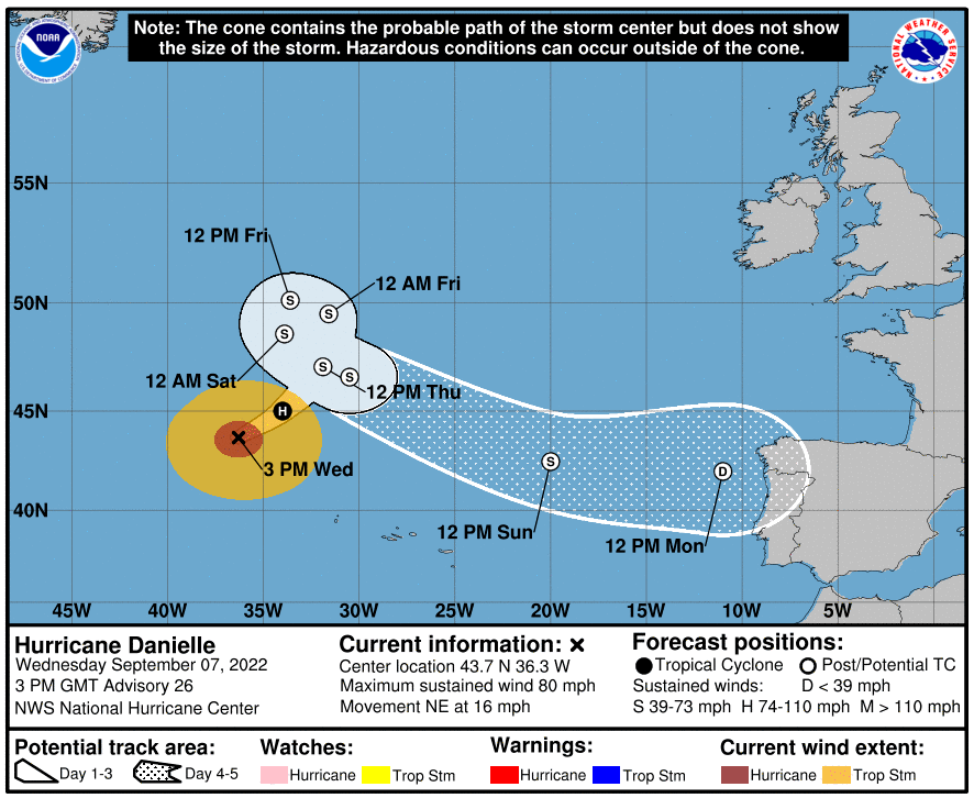
There is the chance that the storm could loop around before moving toward the coasts of Ireland and the United Kingdom, potentially moving as south as western Europe. This track would be good news for an area under extreme drought. Another potential track shows Danielle being absorbed by a non-tropical feature coming to the east out of Canada.
Hurricane watchers at the NHC are also monitoring the potential of numerous tropical waves that are coming off the coast of Africa. The absence of dry air and wind shear has supported the development of these features over the last few weeks, as is typical for this time of the year when tropical activity peaks in this corner of the globe.
Experts are giving one particular wave a medium chance of evolving into a tropical depression or storm on Thursday to Saturday. However, the current steering breezes would take the feature to the north, keeping it at a distance from any land.
A zone of high pressure is expected to take root to the north of the normal path of these waves from Africa by the middle of September. This will combine with a clockwise flow of air to steer these features to the west toward the Caribbean and the U.S.
Lastly, the NHC is monitoring a non-tropical storm system near the southern coast of the U.S. This feature is predicted to move to the south over the Gulf of Mexico in the coming days. At this time, forecasters are predicting that the feature will only have a small period of time to develop into a tropical system. However, if the system takes its time moving to the north, it may have enough opportunity to feed on the warm waters of the Gulf of Mexico and strengthen.
The next name on the designated list is Fiona.
The Atlantic Basin is not the only ocean seeing a heightened amount of tropical activity. The development of Hurricane Kay in the East Pacific on Monday has put much of the southern coast of Mexico in the crosshairs of rain and wind. The storm is forecast to track to the north and further intensify over the next few days.
The feature found plenty of warm water and low amounts of wind shear on its journey to becoming the eighth hurricane of the 2022 East Pacific season. As of Tuesday, Kay was packing sustained winds of 85 mph as it moved to the northwest.
The heaviest of the rains associated with Kay will continue to fall over the western coastline through the end of the week. However, it will be the Baja Peninsula that is the most at risk of flooding because of the elevated terrain in this area. Widespread rain amounts of up to 8 inches are possible on the peninsula with winds also predicted to pick up as Kay moves toward this part of Mexico.
While the U.S. is not forecast to see landfall of this system, there is the chance that the remnants of Kay will hug the coast of California, delivering impacts in the form of steady rainfall and gusty winds to Southern California by the weekend.
The storm may also bring an increase in moisture to much of the Southwest by Saturday and Sunday. Those residents still grappling with the ongoing heat wave will undoubtedly welcome the cloud cover and moisture associated with this system.
Unfortunately, forecasters are warning that Kay could trigger stronger east to northeasterly winds beginning on Friday across Southern California. This could spell trouble for an area already dealing with an increased wildfire risk.
Did you find this content useful? Feel free to bookmark or to post to your timeline for reference later.

January 21, 2024

January 19, 2024

January 18, 2024
