Heavy Rain, Flooding, and Chance of Severe Weather Staring Down the Southern U.S.
January 22, 2024
Posted: October 21, 2022 2:12 pm


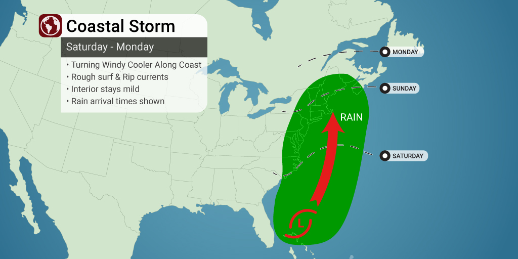
There is a storm brewing off the East Coast of the U.S. How it continues to develop will largely dictate the weather this weekend up and down the Eastern Seaboard.
After a few days of chilly temperatures and even snow in some of the higher elevations, the East Coast is now in the midst of a warming pattern. However, will this return to pleasant weather be spoiled by the arrival of this tropical rainstorm? How the weather develops this weekend from the mid-Atlantic into New England will be greatly influenced by the track and intensity of this developing storm system over the coming days.
Prior to the storm’s arrival, the region can expect to see temperatures increase by 10 – 20 degrees through the eastern third of the country. The warmup has already started for the Midwest and Appalachians with more areas expected to get in on the rising temperatures starting this weekend and continuing through the early part of next week.
Forecasters with the National Hurricane Center (NHC) have had their eyes on this tropical feature spinning off the coast of the southeastern U.S. over the last few weeks. Depending on its future development, the system could generate rough surf conditions and heavy rain for an area stretching from North Carolina through Maine.
If the storm system merely hugs the Eastern Seaboard, it would bring rain to New York City and Philadelphia during the day Sunday with the precipitation reaching as far north as Boston by the evening hours. The system will still bring thick cloud cover, rough seas, and breezy conditions to the region even if it stays well offshore.
However, if the storm continues its strengthening trend, it would deliver torrential rain and the possibility of urban flooding up and down the busy Interstate 95 corridor into Monday. A more intense weather maker would also bring heavy rain to inland areas, possibly expanding into the central Appalachians and up to the Canadian border.
The trajectory of the storm will determine how long the warmth hangs on through the weekend. The mercury may fall up to 20 degrees if the system comes on shore.
Although it is not likely, there is also the chance that the system could develop into a tropical depression or storm as it brings up rich areas of moisture from the Caribbean. This is a part of the Atlantic basin that typically sees a good amount of tropical activity during this time of the year. The wide availability of water temperatures in the 70s and 80s across the Gulf Stream generates the environmental conditions typically needed for storm intensification.
The system would need to carry sustained winds of at least 35 mph for it to be designated as a tropical depression. Likewise, the system would need sustained winds speeds of at least 39 mph for it to fall under the category of a tropical storm.
The next name on the list of tropical features for the 2022 Atlantic hurricane season is Lisa. At this point, forecasters are predicting that the system will take on subtropical characteristics, putting it shy of a named storm. There is also the chance that the system could devolve into an ordinary nor’easter.
A lack of moisture over the summer has left much of the Northeast under the designation of some level of drought. A thorough soaking would be welcome news for a region in need for rain heading into the winter months. Be sure to stay abreast of this developing weather situation if you live along the Atlantic coast.
Did you find this content useful? Feel free to bookmark or to post to your timeline for reference later.

January 21, 2024

January 19, 2024

January 18, 2024