
Heavy Rain, Flooding, and Chance of Severe Weather Staring Down the Southern U.S.
January 22, 2024
Posted: November 10, 2022 10:31 am


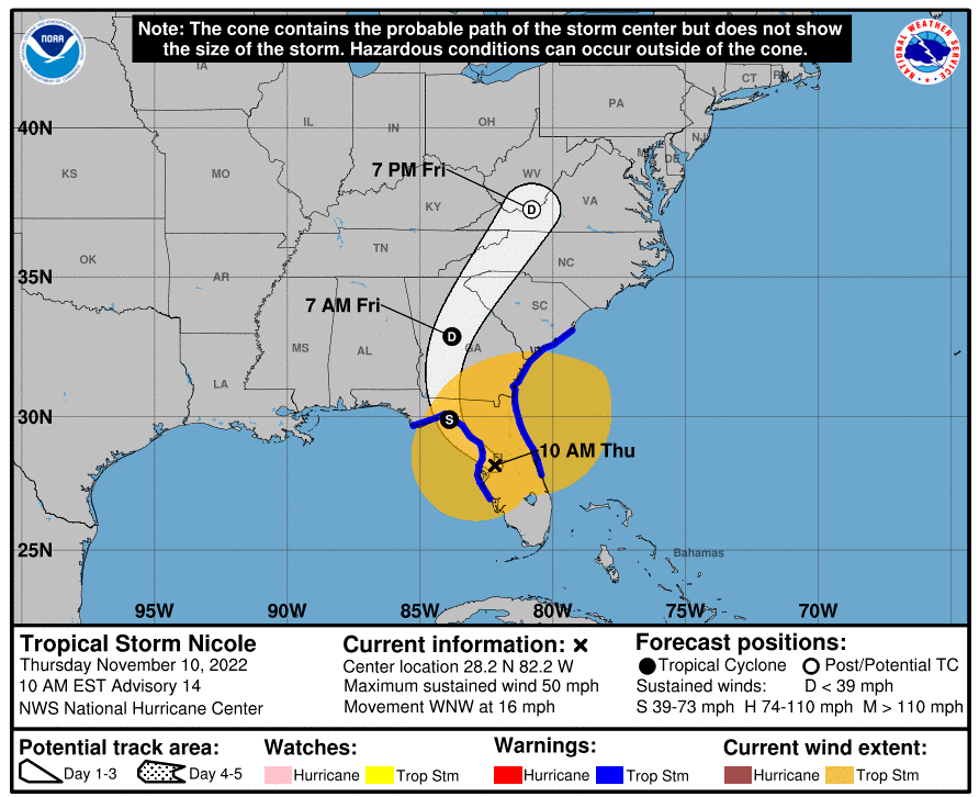
Nicole will not be done after it finishes with Florida. After the storm exits the Sunshine State, it is forecast to trudge up into the interior portions of the Southeast. The storm will likely be designated as a tropical depression when it reaches this corner of the country, eventually devolving into a powerful rainstorm on Thursday into Friday. Here is what you can expect out of Nicole if you live in this region.
Forecasters with the National Hurricane Center (NHC) are predicting that Nicole will briefly move into the Gulf of Mexico on Thursday evening after crossing over the Florida peninsula. The system will then start a trajectory to the northeast, taking it through northern Florida and into Georgia on Thursday night.
The impact zone will begin to see torrential rain and damaging winds ahead of the center of the storm as it churns northward. A general 2 to 4 inches of rain is predicted in an area stretching from central Georgia and into the western and central parts of the Carolinas, up through eastern Tennessee, and as far as southwestern Virginia and the southeastern corner of Kentucky.
Because much of this moisture is expected to fall over a short period of time, rainfall rates could exceed 1 – 2 inches per hour. Rainfall of this magnitude so quickly could overwhelm streams and send them spilling water over their banks. The greatest risk of this type of flooding will happen along the spine of the Appalachians, an area that may see 4 – 8 inches of rain out of this quickly moving storm system.
Meteorologists are warning that urban flooding is likely. This concern will be heightened due to the presence of fallen leaves that may clog storm drains. Cities that may see the impacts of this urban flooding include Atlanta and Charlotte.
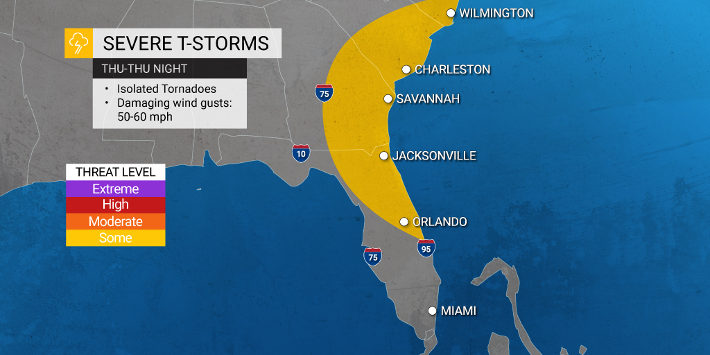
The eastern edge of Nicole’s remnants will be full of warm and humid air, the necessary conditions for thunderstorm development. These storms will carry the risk of strong winds, waterspouts, and isolated tornadoes. The likely time frame for the severe weather will be in the overnight hours on Thursday into Friday, raising the risk of danger of storms that fire up under the shroud of darkness when it is harder to detect tornadoes.
As such, local officials are recommending that residents in this potential zone of impact enable smartphone notifications before going to bed.
The Interstate 85 corridor will be the likely target of wind gusts reaching up to 60 mph. Winds of this stretch may be enough to knock down vulnerable trees or trigger sporadic power outages.
Coastal flooding and minor beach erosion may be another impact that Nicole brings. These impacts will be most likely in coastal Georgia and the Carolinas. The coastal flooding will be the result of persistent rain and above-normal tides. Charleston, South Carolina will be particularly likely to experience this flooding. Water coming in from the Pamlico and Albemarle sounds in North Carolina may also back up into the area’s rivers.
The rain should clear out in the Southeast by Saturday, ushering in drier conditions and moderate temperatures. This pleasant weather will aid in the cleanup efforts after the system blows through. Whatever is left of Nicole will then move up the Atlantic Seaboard through the weekend, bringing rain and wind to the interior Northeast and beyond.
The rain associated with Nicole will be a great benefit to areas of the Southeast that have been dealing with drought conditions. According to the latest data from the U.S. Drought Monitor, the Southeast has been experiencing conditions that fall between abnormally dry and severe.
Did you find this content useful? Feel free to bookmark or to post to your timeline for reference later.

January 21, 2024

January 19, 2024

January 18, 2024
