Heavy Rain, Flooding, and Chance of Severe Weather Staring Down the Southern U.S.
January 22, 2024
Posted: December 1, 2022 3:48 pm


After a brief break in the inclement winter weather, another round of snow and bitterly cold winds are in store for the Upper Midwest to close out the week. When will the wintry weather arrive? Read on for all of the details.
It has already been a messy week in the Upper Midwest with more snow in the forecast. Tuesday brought a winter storm that dumped 4 to 8 inches of new snow throughout the region, including across Minneapolis and St. Paul. Although the Twin Cities will avoid the bulk of the snow at the end of the week, other areas of the northern Plains and Upper Midwest will be in the line of fire for more accumulation totaling as much as 6 inches on Friday night.
The snow machine fired up along Colorado’s Front Range on Monday night before moving into the central Plains by Tuesday. Thanks to this late November blast of snow, Denver International Airport ended the month with 10.9 inches of accumulation, well above the monthly average of 4.5 inches.
By Tuesday morning, the storm was bearing down on the Minneapolis area. Many school districts in the region were forced to let students out early for the day to get them home prior to road conditions deteriorating. A snow emergency was put in place in the Twin Cities later in the day.
By the time the system had moved out of the region by late Tuesday, Minneapolis-St.Paul International Airport had recorded 8.4 inches of snow. This number had jumped to 13.4 inches by Wednesday morning, snarling traffic and causing widespread delays.
The snow also impacted daily life in an area stretching from northern Iowa into southern Missouri. Northwestern Wisconsin and the Upper Peninsula of Michigan also snowfall amounts averaging 4 to 8 inches. Lake Nebagamon saw some of the largest accumulation, coming in at 9.5 inches.
The back end of the weather maker ushered in strong winds that brought the real feel temperature down to below zero through Thursday morning across the Upper Midwest. The winds also posed a challenge to road crews working to clear out the snow.
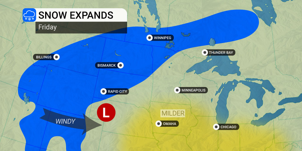
A storm system pushing in from the Pacific Northwest is set to drop more snow in the northern Plains and Upper Midwest beginning Friday. The system will first produce snow across the Rockies late Thursday before heading into the Dakotas by Friday morning. From there, the snow will track through the northern portions of Minnesota and Wisconsin and eventually land in the Upper Peninsula of Michigan late Friday. The flurries will wrap up in the overnight hours on Friday into Saturday.
Accumulation amounts will be limited due to a moisture deficiency within the system and its fast speed. Most areas in the impact zone can expect 1 to 3 inches of snow with a smaller swath of northeastern North Dakota and northern Minnesota expected to see up to 6 inches.
The lingering bitterly cold temperatures from the last system will stick around, translating to snow that will adhere to roads and sidewalks. This will inevitably lead to a slow commute during both Friday commutes.
The area south of the storm track should be prepared for strong winds fire to up Friday. This includes cities such as Kansas City, Denver, and beyond. Gusts of 40 – 60 mph will be the major weather story for the interior West and the High Plains.
Parts of the Plains and Upper Midwest that have snow on the ground will be at risk of blowing and drifting snow because of the high winds. The lingering cold temperatures in this part of the northern U.S. will prevent the snow from melting quickly.
The forecast for next week is also showing the possibility of new snow and continued cold air for the Upper Midwest. There is no doubt that winter is now here to stay.
Did you find this content useful? Feel free to bookmark or to post to your timeline for reference later.

January 21, 2024

January 19, 2024

January 18, 2024