
Heavy Rain, Flooding, and Chance of Severe Weather Staring Down the Southern U.S.
January 22, 2024
Posted: January 19, 2023 11:35 am


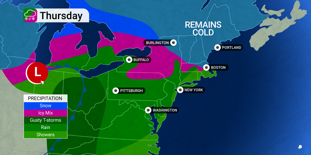
The intense storm system that is bringing more severe weather to the southern U.S. is forecast to deliver a host of winter weather impacts to the interior Northeast as the week comes to a close. Here is what you need to know about this large weather maker.
The system that is currently hammering parts of the Great Lakes with heavy rain and thunderstorms will meet up with a mass of cold air that is forecast to turn this moisture into a mix of wintry precipitation late Thursday and into Friday. While some parts of the East Coast will experience significant snow out of this system, it appears as if the major metropolitan areas of Philadelphia, New York City, and Washington, D.C. will once again be left out of the white stuff.
Before the precipitation turns to snow, it will be thunderstorms causing the issues on Thursday. The areas most likely to see severe weather include much of Ohio and the western edge of Pennsylvania.
Along the busy Interstate 95 corridor, motorists can expect rain and low cloud ceilings. The chance of fog may also create airline delays in some of the nation’s largest hubs. By late Thursday, you can expect the chance of thunderstorms featuring heavy rain and strong wind gusts to hit as far as the coastal regions of mid-Atlantic.
This far-reaching storm will impact nearly every area of the eastern U.S. in some form. However, it will be the interior Northeast that sees the wintry precipitation.
Freezing rain and drizzle may impact a large area of northern Pennsylvania, upstate New York, southern Vermont and New Hampshire, and interior portions of Connecticut and Massachusetts. This potentially dangerous precipitation will hang around from Thursday morning through Friday morning. Residents in these areas are being warned to look out for untreated bridges and overpasses as well as potentially icy sidewalks.
The storm system responsible for all of the inclement weather in the Upper Midwest this week is predicted to turn to the east on Thursday night and Friday when it reaches the Great Lakes region. This is when it will find the colder air needed to generate snow.
People living in northern New York and throughout much of New England should be prepared for a general 3 to 6 inches of snow. The higher terrains of the Adirondack, Green, and White mountains may see up to a foot of snow or more.
Once again, Philadelphia, New York City, and Washington, D.C. will avoid the wintry precipitation, continuing the ongoing snow drought for these major East Coast cities. Meanwhile, Boston may see the flakes fly as the system approaches the coast.
Despite last week’s nor’easter, Boston has only see about 5 inches of snow this winter. The weekend nor’easter was responsible for about 3.5 of these inches. These measurements put the city far below normal for snowfall at this point in the season.
Bean City may see another shot of snow by late Friday, however, there is also a good chance that the significant accumulation remains north of Boston. The current forecast puts New Hampshire and Maine in the bullseye for the most meaningful accumulation.
Looking at the long-range forecast, there is a decent chance that New York City could see a new record for the longest stretch of days without measurable snow. The city would need to hang on until February 6 with no snow to break this record.
The next chance of moisture is set to hit this part of the East Coast later this weekend and into next week. However, the temperatures look like they will remain warm enough to keep any moisture falling as rain rather than snow in the Big Apple. There is still an outside possibility that the track of the weather maker could move close to the coast, creating a higher chance of snow in New York City and its environs.
Did you find this content useful? Feel free to bookmark or to post to your timeline for reference later.

January 21, 2024

January 19, 2024

January 18, 2024
