Heavy Rain, Flooding, and Chance of Severe Weather Staring Down the Southern U.S.
January 22, 2024
Posted: February 3, 2023 11:47 am


Some of the coldest air this winter is on its way to the Northeast beginning on Friday as a polar vortex bears down on the region. Some historic record-low temperatures may fall as the blast of Arctic air infiltrates the region. Who is in line for this cold and how long can you expect it to hang around? All of the details are here.
A strong polar vortex this winter has corralled the bulk of the Arctic air and kept it in the Arctic Circle. This air remains entrenched in the Arctic when the polar vortex is strong. A weakening of this vortex over the last few days has allowed some of the frigid air to escape and migrate to the south, sending it across Canada and into portions of the northern U.S.
The mercury will fall beginning Friday as a small lobe of the polar vortex breaks off and plunges to the south. While the actual temperature will be cold in its own right, the real feel readings will be downright dangerous in some areas. The temperature will begin its downward trajectory throughout the day Friday across New England and into the interior mid-Atlantic. You can expect the temperature to fall 10 – 20 degrees from the morning low.
Complicating the weather situation will be the gusty winds ushered in by the cold front. Winds will clock in at 15 – 25 mph with some gusts hitting 40 mph or more. The areas most likely to see the strongest winds are the central Appalachians and the mid-Atlantic. By Friday night, parts of New England may see winds measuring between 40 and 60 mph.
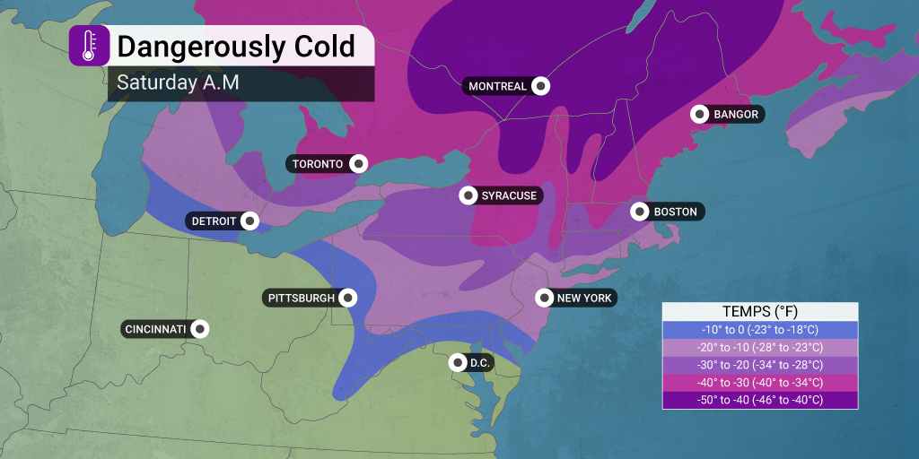
The temperature will fall further when night falls on Friday. This is also the time frame when the winds are forecast to be their strongest. The combination of cold air and gusty winds will bring real feel temperatures to 30 through 50 below zero in a zone stretching from northern New York and up into New England.
The higher terrains of this region may see even colder real feel readings. For instance, the summit of Mount Washington in New Hampshire may experience real feel readings that land between 80 to 90 degrees below zero.
It will be an exceptionally cold start to the day in Boston on Saturday. In fact, with lows approaching 10 degrees below zero, there is a chance that it may be the fourth coldest morning ever since 1936. The record for the city is 14 below zero.
This upcoming rush of Arctic air may be the coldest weather event of the winter so far for parts of New York and New England. This is a bold prediction after what the region already saw over the Christmas holiday.
The coldest air will impact the northern reaches of New England the Northeast with slightly warmer readings to the south. For example, New York City will drop into the single digits on Saturday morning with readings in the teens for Philadelphia, Baltimore, and Washington, D.C. The cold air will support the development of snow squalls across parts of the interior Northeast and into New England. This threat will last through Friday night.
The good news for those not looking forward to the frigid weather is that it is not expected to stick around for long. The temperatures are expected to quickly rebound after the initial blast of Arctic air.
You can expect warmer temperatures by the end of the weekend as the polar vortex lobe makes a turn to the north by Sunday. This will bring in warmer air that has already settled across much of the West.
The temperature swing from Saturday to Sunday will be quite dramatic with some areas seeing a swing of 20 – 40 degrees. Many areas of the Northeast will even see readings that are slightly above normal for early February by Sunday.
For instance, after seeing a high in the upper 20s on Saturday, New York City is expected to land in the upper 40s by Sunday. The shift will be even more noticeable in Boston, going from a high in the upper teens on Saturday to a forecast high of about 47 degrees on Sunday. These above average readings will stick around for the upcoming week.
Did you find this content useful? Feel free to bookmark or to post to your timeline for reference later.

January 21, 2024

January 19, 2024

January 18, 2024