
Heavy Rain, Flooding, and Chance of Severe Weather Staring Down the Southern U.S.
January 22, 2024
Posted: February 16, 2023 3:38 pm


It is already shaping up to be another treacherous day on the roads for millions of Americans as a dynamic storm system settles across the central U.S., impacting the Gulf Coast with thunderstorms and tornadoes and the Midwest and Great Lakes with wintry conditions. Here is the latest on this monster weather maker and when you can expect the conditions to calm down.
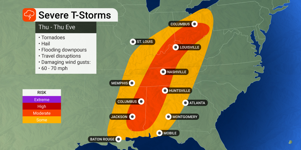
Over 40 million Americans are under the threat of some type of severe weather impact on Thursday. Residents of the Gulf Coast are facing heavy rain, hail, strong winds, and isolated tornadoes. The biggest risk with this system is likely to be the winds clocking in at 60 – 70 mph.
These winds pack the potential to bring down power lines and trees. The areas much likely to experience widespread power outages include West Virginia, Ohio, southern Indiana, Kentucky, and western Pennsylvania. This area is particularly at risk because the grounds are wetter than normal due to excessive rain and snow in recent weeks, making them more susceptible to lose grip of trees.
The torrential rain has already triggered numerous flood warnings on Thursday across parts of northwestern and south-central Kentucky. The region has picked up 2 – 4 inches of rain out of this system. Officials in Daviess County reported having to conduct a water rescue as floodwaters washed away a vehicle.
A tornado watch is in effect for over 1.7 million people in portions of Mississippi and Louisiana. The watch is in effect until at least 5 pm local time. In addition to the threat of tornadic activity, the region is also under the gun for large hail, flash flooding, and damaging winds. Officials at Mississippi State University in Starkville moved operations to the remote space at 12:30 pm local time Thursday because of the threat of severe weather in the area.
Parts of western Tennessee were also put under a tornado watch Thursday morning. Making the situation worse is a radar failure at the National Weather Service (NWS) office in Memphis. The NWS said it was likely a lightning strike that sent the radar offline. The NWS is leaning on radars near Little Rock and beyond to provide information about severe weather in the Memphis area until they can repair the damage and get back up and running.
While the southern half of the nation is dealing with severe weather and the threat of tornadoes, it is snow that is creating the headaches to the north. Heavy snow moved across the northern Plains to start the day Thursday, delivering dicey road conditions. The Iowa Department of Transportation said that all areas across the southern third of the state were dealing with snow-packed roads.
According to the Iowa State Patrol, there have been about 100 calls for service in the morning hours. Near white-out conditions are complicating travel as winds whip up and send the snow blowing. These bands of snow have now moved into Wisconsin, taking aim at the cities of Madison and Milwaukee.
The risk of severe weather in the South will hang around until after the sun goes down on Thursday. This is particularly worrisome as tornadoes that spin up under the cover of darkness are over twice as deadly as those that happen in the light of day.
While the snow will start to lighten up in the Midwest by early Friday, another threat of ice will move across northern New York state and into the northern portions of New England late Thursday into Friday. The ice event will get its start in the Adirondack Mountains located in northern New York before moving into the Champlain Valley of Vermont and the Green and White Mountains of New England. This ice will begin to coat the region Thursday night and into Friday.
Areas near Detroit and in southern Michigan will also see some of the first impacts Thursday evening before the messy precipitation makes its way toward the coastal areas of Maine by Friday. You can expect ice to accumulate in the range of 0.10 to 0.40 of an inch. This is enough ice to bring down tree limbs and power lines.
Ice and sleet of this magnitude will also lead to the potential of slippery roads and sidewalks. The cleanup efforts will be exacerbated by the possibility of downed power lines and trees, making it more difficult to treat roads. Although it has been a fairly mild winter for much of New England, forecasters are warning that this end of week ice event may be a preview of a potentially wintry March and April for the region.
Did you find this content useful? Feel free to bookmark or to post to your timeline for reference later.

January 21, 2024

January 19, 2024

January 18, 2024
