Heavy Rain, Flooding, and Chance of Severe Weather Staring Down the Southern U.S.
January 22, 2024
Posted: February 20, 2023 9:04 am


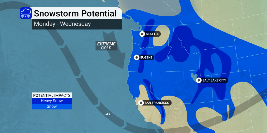
A southward dip in the jet this weekend has set the stage for a pattern of cold temperatures and wintry precipitation across the West Coast in the coming days. This widespread outbreak of cold weather could cause major travel disruptions to a large part of the West, particularly the Pacific Northwest. Here is what you need to know heading into the new week.
Residents of the Northwest may remember last year’s cold outbreak, also hitting this same week in February. During this cold snap, Seattle hit a record low of 23 degrees on February 23. Will the temperatures get as cold this time around? Only time will tell.
The jet stream dip can be attributed to high pressure that has been building up in Alaska, pushing the cold air to the south. This atmospheric condition is pairing with a storm that fired up over Hudson Bay, Canada to bring the Arctic air into western and central portions of Canada and into the Pacific Northwest and the North Central U.S.
The mercury will plunge as much as 25 – 50 degrees below normal for this time of the year, sending those in the path racing for warmth. The system will also bring significant amounts of snow to the higher terrains of the Cascade Mountains and the Sierra Nevada.
Now is the time to get any outdoor chores done. The coldest of the temperatures are forecast to hit on Thursday and last through Saturday. The core of the frigid temperatures will be positioned over the Pacific coastal areas.
At the same time that the cold is gripping the region, forecasters are predicting at least one or two storm systems to move in from the Pacific and stretch across the interior West. These storms will fire up by the middle of the week and hang on as February comes to a close and the calendar flips to March. Each weather maker will bring the chance of snow, strong winds, and more cold air.
The Cascades and the Sierra Nevada are predicted to pick up snowfall measured in feet by the end of the week and into the last weekend of February. In addition to the usual snow along these higher terrains, there is also the chance of measurable snowfall across the Interstate 5 corridor.
This includes the cities of Seattle and Portland, areas that do not generally experience widespread snow events. There is a chance that this area may see snow showers late Tuesday and into Wednesday. Highs on Wednesday through Friday will have a hard time getting out of the 30s, making it likely that any moisture that falls may come down as snow. Be sure to stay tuned to the developing forecast to learn where the snow will track precisely.
The storm will also usher in gusty winds. These winds are expected to create blowing and drifting snow over some of most well-traveled mountain passes in the Cascades and the Sierra Nevada. The winds and precipitation may also trigger airline delays and cancellations throughout the Northwest and the interior West. It is a good idea to check with your airline if you have travel plans over the next few days.
This same weather maker will also impact the Desert Southwest and Southern California by the end of the weekend. Snow levels may dip low enough to bring the white stuff to the Grapevine in Southern California.
Although the forecast is still uncertain at this point, any precipitation will go a long way in helping to alleviate the drought conditions throughout the Golden State and beyond.
Did you find this content useful? Feel free to bookmark or to post to your timeline for reference later.

January 21, 2024

January 19, 2024

January 18, 2024