Heavy Rain, Flooding, and Chance of Severe Weather Staring Down the Southern U.S.
January 22, 2024
Posted: March 3, 2023 9:09 am


Just because it is now officially the meteorological spring, it does not mean that Old Man Winter got the message. A monster winter storm is going to drop heavy snowfall across a zone stretching over 1,300 miles long at the end of the week. Here is what you need to know about this developing weather situation.
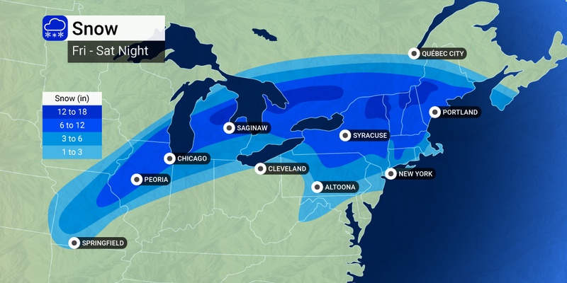
The cross-country storm that has been moving from west to east this week is now ready to unleash wintry impacts to the Midwest and into the Northeast to close out the week. The storm is now gearing up to dump snowfall of 6 – 12 inches from the mid-Mississippi Valley up through New England.
Residents in this part of the country should be prepared for a slew of travel disruptions in the coming days. Major airport hubs will likely be impacted by the snow and ice, including those in Chicago, Detroit, and Boston. Temperatures will be cold enough to necessitate deicing operations, backing up flights across the country.
It will be heavy rain and poor visibility hampering airport operations to the south, including those in Philadelphia, St. Louis, and Pittsburgh. Because of the domino effect of flight disruptions, travelers across the country may be impacted by this weather system.
How much snow can you expect? A general 6 – 10 inches of snow is expected to hit the Chicago area. Should this forecast prove true, it will be the Windy City’s biggest snowfall event of the season. Detroit is expecting 3 – 6 inches while Boston is in line for at least a few inches.
The storm system will find colder air as it moves to the north on Friday. This will spur the transition from rain to snow in places such as eastern Kansas and northern Missouri. By Friday afternoon, the snow line will move into Chicago. This will make for a potentially dicey evening commute. Snow will come down at a rate of 1 – 2 inches per hour, triggering rapidly deteriorating road conditions.
Snowfall amounts will vary greatly within a small zone thanks to a mass of warm air to the south of the frontal boundary. For instance, the northern and western suburbs of Detroit may see 6 – 10 inches of snow while the city itself only picks up 3 – 6 inches.
Other impacts associated with this storm system will include locally heavy rain, fog, and severe thunderstorms. The severe weather will fire up along parts of interstates 64 and 70 across the Midwest. These storms may reach as far north as Interstate 80 in Ohio by Friday afternoon. Be sure to take care when heading out on the roads.
Just as this massive winter storm is churning across the central U.S., a secondary system is forecast to fire up along the mid-Atlantic coast. This second storm will eventually merge with the system moving in from the west late Friday and into Saturday.
The secondary storm is predicted to become the more dominant of the pair, delivering heavy snow to parts of New York state starting late Friday and lasting into the start of the weekend. The central Appalachians will also likely see a bout of snow, sleet, or freezing rain on Friday. A thick fog may also develop over the region.
It will be a mixed bag of conditions in New England. While some parts of Boston will see snow, other areas may see the precipitation transition to rain more quickly. Areas north and west of the city proper will see the most significant snow accumulation. The hardest hit areas of central and northern New England could see snowfall amounts in the range of 1 -2 feet, especially in the higher elevations. The snow may stick around through Saturday night in coastal Massachusetts.
New York City is predicted to miss out on the snow this time around. The moisture is expected to change over to rain rather quickly late Friday in and around the city, limiting snowfall accumulation to no more than an inch. However, the rain could be heavy at times, especially in the overnight hours heading into Saturday.
The rain and fog may complicate air travel and road conditions up and down the Interstate 95 corridor on Friday night and Saturday. It is a good idea to check your flight status if flying into, out of, or through airports in Philadelphia, Baltimore, Washington, D.C., and New York City.
Forecasters are warning that this return to winter weather is going to hang around for a few weeks in the Midwest and Northeast. Do not put those snow shovels and gloves away quite yet. More of this could be on the way heading into next week.
Did you find this content useful? Feel free to bookmark or to post to your timeline for reference later.

January 21, 2024

January 19, 2024

January 18, 2024