Heavy Rain, Flooding, and Chance of Severe Weather Staring Down the Southern U.S.
January 22, 2024
Posted: March 6, 2023 4:30 pm


It will be a tale of two seasons this week throughout much of the eastern two-thirds of the U.S. While the northern part of the country will be dealing with accumulating snow as winter hangs on, it will feel more like spring across the southern tier of the U.S. thanks to severe weather outbreaks. Here is a look at this push and pull during the first full week of March.
Snow has already begun falling across the northern Plains to start the work week. The forecast has this snow moving into the portions of the Midwest and Northeast by Tuesday. Although this weather maker will not bring as much accumulation to the region as last week’s snow event, it will be enough to make for some messy commutes and minor life disruptions.
The Dakotas ended the weekend with snow falling. Nearly a foot of new snow fell in a zone to the south of Bismarck, North Dakota. It was another dicey morning commute on Monday for Minneapolis with well over 6 inches already recorded in the Twin Cities area.
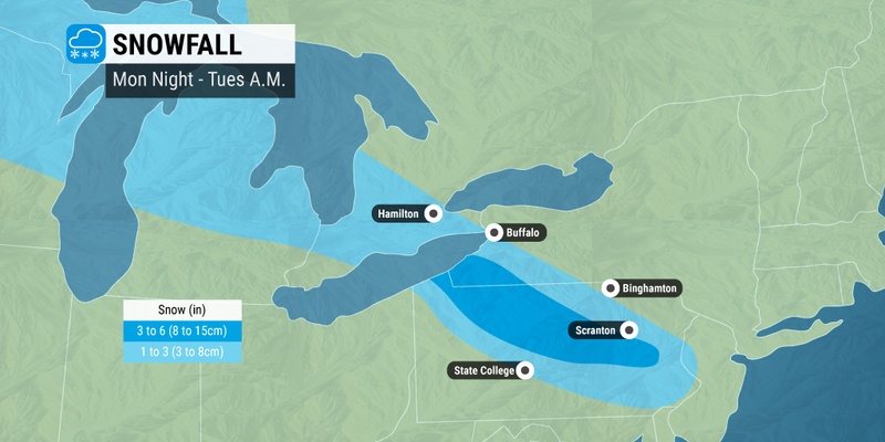
The snow will hit the interior portions of the Northeast by late Monday and early Tuesday. The quick-moving storm system will bring snow that falls at a fast clip, particularly across northern Pennsylvania.
This will translate to snow-packed roads across stretches of interstates 80 and 81 in Pennsylvania and New Jersey. By early Tuesday, portions of interstates 86 and 90 in New York state may also be dealing with deteriorating conditions.
Cold air will track into the region at the back end of the storm system. This will set the stage for the potential of more wintry precipitation by the end of the week should the appropriate amount of moisture move into the area.
This storm event would likely fire up late Wednesday in the Rocky Mountains before moving through the Upper Midwest to close out the week. Unlike the current system churning through the northern Plains and eastward that is moving swiftly, this next storm could have some staying power. This slower movement would mean that more than a foot of snow is possible in some of the hardest hit areas.
Several inches of accumulating snow is in the forecast for a number of cities, including Denver and Minneapolis. This storm system will also bring the possibility of gusty winds that hit as high as 45 mph. The winds would most likely gain strength on Thursday.
As is typical for these large March weather systems, the southern side of the storm will feature more warmer temperatures. While this will spare the South the wintry weather, it will increase the odds of severe thunderstorms.
The area of the southern Plains near the border of Texas and Oklahoma will be under the gun for persistent rain that brings several inches of moisture. This zone of heavy rain will extend into Tennessee and Kentucky by late week.
You can expect widespread rainfall that totals up to 2 inches in this zone with some isolated locations hitting as much as the 4-inch mark. This is the same part of the country that experienced an unseasonably wet February. The added moisture expected this week will inevitably make the region more likely to be dealing with flooding problems in low-lying areas. For instance, some of the tributaries of the Mississippi River are experiencing minor flooding.
The warm and moist air filtering up from the Gulf of Mexico will also pose the risk of severe thunderstorm development. Be sure to stay on top of this week’s developing forecast. The impacts will likely be felt by millions of Americans, regardless of if it comes as snow or rain.
Did you find this content useful? Feel free to bookmark or to post to your timeline for reference later.

January 21, 2024

January 19, 2024

January 18, 2024