Heavy Rain, Flooding, and Chance of Severe Weather Staring Down the Southern U.S.
January 22, 2024
Posted: April 21, 2023 9:00 am


It has been a stormy week across the U.S. with the severe weather expected to continue on Friday and through the weekend. Here is a recap of some of the most noteworthy weather events of the week as well as a look ahead to what you can expect on Friday and beyond.
At least three deaths were blamed on a tornado that roared through the town of Cole, Oklahoma on Wednesday evening. It was not until the next day when the sun came up that residents got a full look at the damage.
As of late Thursday, the sheriff’s office was warning that more fatalities will be confirmed as search and rescue crews continue to shift through the rubble.
The National Weather Service (NWS) out of Norman, Oklahoma said that they believe the storm was an EF3 tornado. Cole is located approximately 30 miles south of Oklahoma City.
Other towns in the Sooner State that reported tornado touchdowns on Wednesday included Shawnee and Norman. There were also twisters reported in Kansas and Iowa across the same time period.
The storms that tore through the central Plains also came with large hail and damaging winds. For instance, hail the size of tennis balls came down on Interstate 29 near the town of McPaul, Iowa.
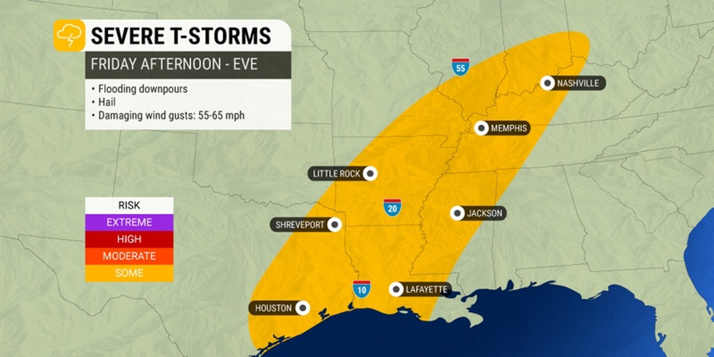
The threat of storms will move out of the nation’s heartland and across the Gulf Coast and into the Mississippi Valley on Friday. The storms will be fueled by warm and humid air in place over the region ahead of the front.
You can expect the risk of the severe weather to hang around through Saturday in this part of the country. In addition to the risk of tornadoes, the weather maker will also produce damaging hail and strong winds.
Sandwiched in between two pleasant days of weather, the end of the work week will bring stormy conditions to the Gulf Coast.
New Orleans is forecast to see a slew of thunderstorms on Friday that dump heavy rain across the city. Highs will top out in the upper 70s with muggy conditions and winds at 10 to 20 mph. The threat of storms will linger through the evening hours prior to partial clearing.
Houston will get off to a stormy start to the day before the weather finally settles into a calmer pattern. The metro area will see the chance of scattered thunderstorms in the morning before the clouds begin to break up later in the day.
It will be a warm day with a forecast high of 84 degrees.
The threat of thunderstorms will extend upwards from the coastal areas into the interior portions of the region. For instance, the forecast for Jackson, Mississippi calls for showers and storms with the possibility of heavy rainfall.
Winds will be out of the south at 10 to 15 mph with a predicted high in the low 70s. The rain will move on after the sun sets but not before more storms likely pop up in the evening hours.
The stormy conditions will also be the story of the day moving up through the Mississippi Valley and beyond. Little Rock could see severe weather during the morning hours that transitions to a steady rain later in the day.
Highs will land in the mid 60s. Winds will be blowing out of the north at 10 to 15 mph. Skies will clear in the capital city of Arkansas in the overnight hours, ushering in a pleasant weekend.
Memphis will also be under the gun for storms throughout the day. The city is predicted to see sporadic heavy rain showers and thunderstorms. The mercury will hit about 65 degrees for a high with lows falling into the upper 40s. Humid conditions will also be a noticeable weather element for the day.
Those in the Northeast will enjoy one more pleasant day on Friday before more rain moves into the region just in time to spoil the weekend. New York City is forecast to see partly cloudy conditions with a high of about 72 degrees.
The clouds will build overnight with lows dropping into the mid 50s. While the rain will hold off on Saturday morning, the skies may open up by the afternoon or evening. Rainfall amounts of about a half of an inch are in the forecast for the overnight hours on Saturday.
Washington, D.C. is expecting an exceptionally warm day on Friday with a forecast high of about 89 degrees. Mostly sunny skies will help to bring the mercury up to this unseasonable level. It will also be a nice evening with lows only landing in the low 60s.
A big change will be on the way to the Southeast and the mid-Atlantic on Saturday. The greatest risk of thunderstorms on Saturday will be across the central and eastern portions of the Carolinas and up into the southern half of Virginia.
Cities in the bullseye for Saturday’s storm activity include Charleston, South Carolina; Charlotte, North Carolina; and Richmond, Virginia.
The moisture will make its way into New England on Sunday, leaving the mid-Atlantic a chance to dry out heading into the new week. Cooler and calmer weather conditions will be on tap on Sunday and into Monday for this part of the country.
Did you find this content useful? Feel free to bookmark or to post to your timeline for reference later.

January 21, 2024

January 19, 2024

January 18, 2024