Heavy Rain, Flooding, and Chance of Severe Weather Staring Down the Southern U.S.
January 22, 2024
Posted: July 7, 2023 2:08 pm


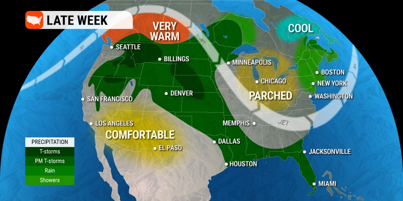
A number of states are now in the danger zone of storm development to end the work week and usher in the weekend. The searing heat and high humidity levels will serve as the base of this storm development across the nation’s heartland. Forecasters are warning that some of these storms could pack severe impacts. Here is a look at what parts of the U.S are most at risk and when these storms may develop over the coming days.
The upcoming storms will likely disrupt outdoor plans for millions of Americans this weekend with significant amounts of rain. The storm cells will also bring the danger of damaging winds, hail, and isolated tornadoes. Some of the storms may linger over one area for a few days, increasing the risk of flash flooding.
The areas most at risk for these storms include the Plains states and parts of the Mississippi River and Ohio valleys. Friday’s threats will target the central and Southern Plains, including parts of eastern Colorado, Kansas, Nebraska, and Oklahoma. This zone has already been in the crosshairs of severe weather this week.
Cities that may experience stormy conditions later Friday include Oklahoma City and Kansas City. The storms may expand as far south as Amarillo, Texas. The northern edge of the weather maker will stretch into Dakotas while the eastern fringe could travel as far as Minnesota. While the northern and eastern edges of the storm complex will not deliver as big of a punch, there is still the possibility of travel disruptions associated with this part of the activity.
Wind gusts as high as 70 mph are a possibility with Friday’s activity. Wind speeds of this magnitude could easily bring down trees and power lines.

The threat of severe storms will roll on into the weekend, bringing areas to the south and the east into the potential impact zone. The biggest disruption with Saturday’s weather will be heavy rain that could limit the outdoor plans of many families during this busy summer weekend.
Saturday’s severe weather threat will extend from the central Plains into some portions of the Ohio Valley. A weak cold front will bring in enough moisture to trigger drenching rainfall.
Outdoor plans could be in jeopardy on Saturday in cities such as Wichita, Oklahoma City, St. Louis, Memphis, Nashville, and Louisville. The storms may linger to the west in Denver and up into the southeastern corner of Wyoming.
Rainfall rates could hit as much as 2 inches per hour with these moisture-rich storm cells. Rain of this magnitude has the potential of triggering flooding concerns, particularly in low-lying areas. While the rain will be a nuisance to those hoping to get outside over the weekend, a large swath of Kansas and Missouri is in dire need of precipitation as drought conditions persist.
Saturday will also bring another day of strong winds. Gusts of up to 90 mph are in the forecast for central Plains states. Be sure to keep an eye on your local forecast and secure outdoor furniture.
The storms will move deeper to the southeast on Sunday, ushering in a rocky end to the weekend. The risk of severe weather will persist in cities such as Little Rock and Memphis. Dallas and Fort Worth will also be under the gun for storm development by Sunday afternoon and evening as the line of cells stretches to the south and the east.
Motorists along interstates 20, 35, 40, and 55 will want to keep an eye on the weather. Torrential rain could create visibility issues and ponding on the roadways along these heavily traveled stretches of highway.
The sporadic storms are forecast to hang on across the central portions of the U.S. well into next week. Meteorologists will continue to fine-tune the forecast in the coming days as the models become clearer.
Did you find this content useful? Feel free to bookmark or to post to your timeline for reference later.

January 21, 2024

January 19, 2024

January 18, 2024