Heavy Rain, Flooding, and Chance of Severe Weather Staring Down the Southern U.S.
January 22, 2024
Posted: July 28, 2023 12:06 pm


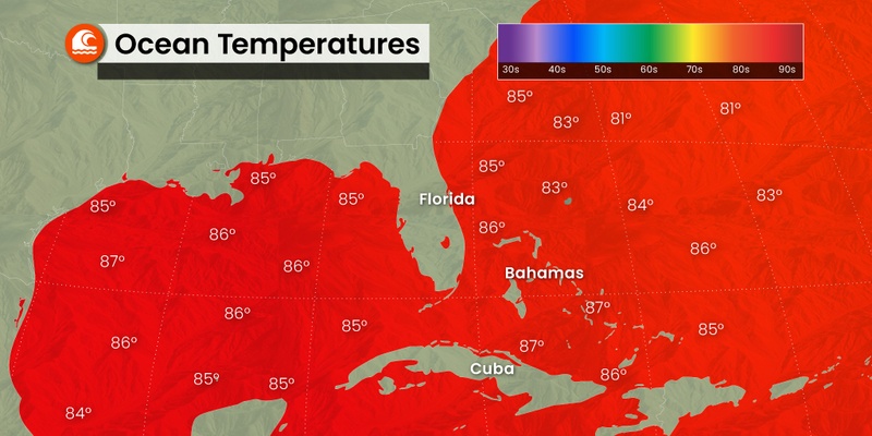
The National Hurricane Center (NHC) has stepped up its surveillance this week, warning that a new named tropical feature could take root by the time the calendar turns to August. This new activity is happening as the 2023 Atlantic hurricane season kicks into high gear heading into the new month. Here is what the tropics are looking like during what is normally the quiet before the storm.
There have been four named tropical systems thus far this season in the Atlantic basin. However, this number could change in the coming days as more tropical waves move off the coast of Africa and into the Atlantic Ocean. These waves originate as disturbances over the Indian Ocean that gradually pick up steam and move to the west across Africa as a mass of strong winds, thunderstorms, and Saharan dust.
Once they come out over Africa and into the open waters of the Atlantic, they often find the ingredients that they need to develop into named features.
A more robust tropical wave season this year has been responsible for the formation of tropical storms Bret and Cindy in June. However, it has been quieter as of late as the Caribbean Sea has been flush with an abundance of wind shear to break up any potential formations.
This is not unusual for the month of July in this part of the basin, creating what is typically a lull in tropical activity in the middle of the summer.
It is also not out of the question that some of these waves may sneak through the pockets of wind shear and find an area of the ocean that is more conducive to tropical development. This is what forecasters believe may happen in the coming days as a wave that is located to the southwest of the Cabo Verde Islands intensifies.
As of late Thursday, the NHC was predicting that this wave has a medium chance to develop into either a tropical depression or a named storm by the end of July. The feature is forecast to move to the west before taking a turn to the northwest in the coming days.
This path would take it to the northeast of the Leeward Islands by later in the weekend before it moves into the central Atlantic basin by the early part of next week. The current models indicate that the feature could be a threat to Bermuda by the middle of next week.
The track of this potential named storm will be largely influenced by a southward dip in the jet stream positioned over the eastern half of the U.S. by early next week. This is the same jet stream movement that will bring down cooler air from Canada and put an end to the current heat wave in the northern half of the U.S. The circulation of air around this dip in the jet stream will likely push any tropical moisture away from the U.S.
The feature will be called Emily should it take on official characteristics of a tropical storm.

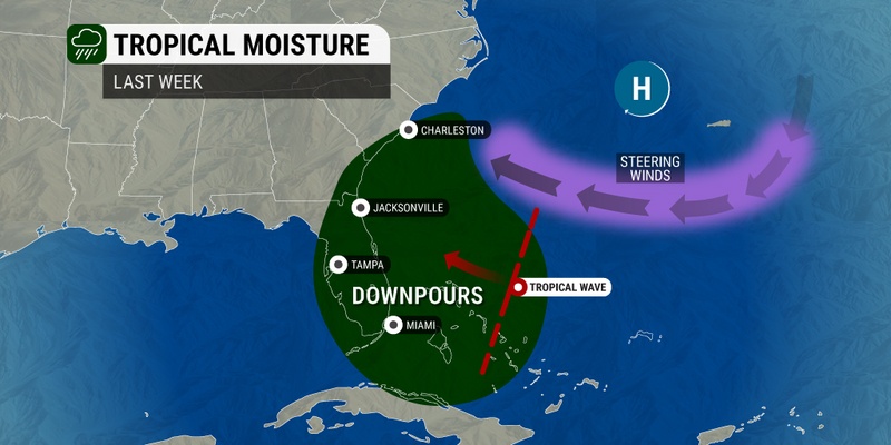
Regardless of if this tropical wave develops into a named storm, it is going to be a soggy weekend for much of Florida and the coastal areas of the Southeast thanks to a tropical disturbance currently churning over the Caribbean. The surge of tropical moisture will fuel the chance of flash flooding and sporadic storms.
It is not likely that this disturbance will take on tropical characteristics. Any development would be weak in nature. The cloud cover associated with this disturbance is predicted to bring down the mercury a notch in Florida. In addition, the moisture will be a welcome sight for the western part of the Sunshine State, an area that is struggling with ongoing drought conditions.
There have been five named tropical systems thus far this season, leaving plenty of space to hit the average of 14 named features for the year. The official season runs from June 1 through November 30, although it is not unusual for named storms to pop up just prior or after those dates.
Of these five named storms, only one developed into a hurricane. Hurricane Don churned in the central Atlantic just last week but did not impact any land on its journey.
Hurricane experts are predicting that the El Niño phase will get going in earnest during the latter part of the hurricane season, working to mitigate the risks of tropical development. However, the basin could still see an active stretch by the middle of August and lasting through September. You will not want to keep your eyes off of the tropics if you live in an area typically impacted by tropical weather.
Did you find this content useful? Feel free to bookmark or to post to your timeline for reference later.

January 21, 2024

January 19, 2024

January 18, 2024