Heavy Rain, Flooding, and Chance of Severe Weather Staring Down the Southern U.S.
January 22, 2024
Posted: August 10, 2023 9:30 am


Approximately 100 million Americans will be at risk of severe weather this week as storms continue to threaten much of the central and eastern portions of the country well into the weekend. Here is what the latest forecast models are predicting.
The eastern two-thirds of the U.S. have seen an unusually active weather pattern for the middle of August. This is usually the time of the summer when storm activity begins to decrease. However, that has not been the case this year with daily thunderstorms a regular occurrence for many communities.
In addition to thwarting outdoor plans and disrupting travel during the busy summer season, the active weather partner has also created deadly flash flooding events. Unfortunately, two major storm systems are beginning to gear up and drop more rain and severe weather impacts through the weekend.
The middle Mississippi River Valley and the Tennessee Valley experienced the worst of the storm activity on Wednesday. Heavy rain and high winds were the primary impacts and will continue to be in the days ahead. The line of storms pushed through the region, heading into the western portion of the Carolinas by daybreak.
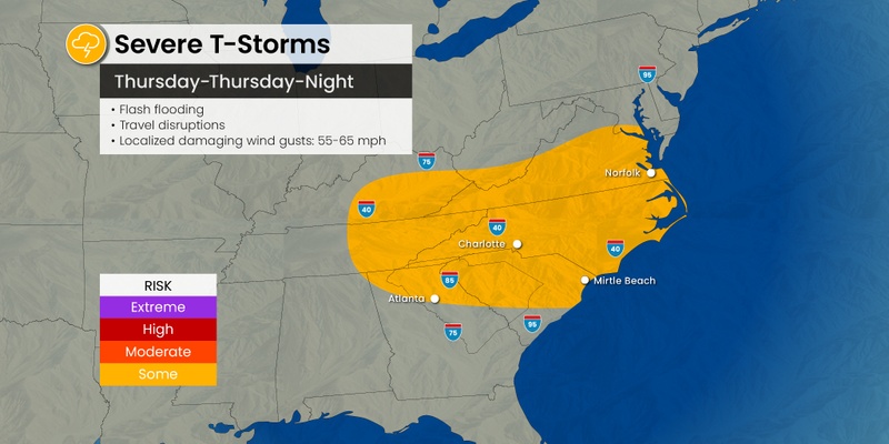
The situation does not look to improve much on Thursday. More airline delays and cancellations are in the cards as the storms are predicted to fire up again. The busy airline hubs in Charlotte, Atlanta, Washington, D.C., Baltimore, New York City, and Philadelphia could all be impacted by these storms. Motorists may also experience delays on the road due to poor visibility and ponding.
Although Thursday’s storm activity is forecast to be more widespread in nature in the Northeast, locally severe weather is still possible. The storms will eventually make their way south throughout the day, focusing on the mid-Atlantic and into the Southeast.
The strongest storms are expected to ignite in an area from North Carolina down into Georgia. Gusts of up to 65 mph are possible along the southern edge of the weather maker. Winds of this intensity will likely knock out power and bring down trees.
The timing of the storms will vary depending on location. For instance, the bulk of the Interstate 85 corridor will see the greatest chance of activity earlier in the day.
While the most widespread storms will likely avoid the Northeast, there is still the chance of heavy rain across parts of Pennsylvania, southeastern New York state, and northern New Jersey. This includes potential impacts of urban flooding for the large metro areas of Philadelphia and New York City.

By the end of the day Thursday, those in New England will be in the crosshairs of this massive storm system. The flooding rain will come just a few days after this corner of the country experienced severe storms. Forecasters are warning that New England will also be at risk of seeing isolated tornadoes develop.
Cities that need to be alert for potentially dangerous weather include Hartford, Providence, and Boston. It is a good idea to enable weather alerts on your smartphone before heading to bed on Thursday in the event that the storms fire up under the cover of darkness.
Yet another storm system is on the horizon for the Midwest on Thursday and Friday. The northern Plains will feel the first of these impacts on Thursday. Potential elements associated with this storm system include high winds, flash flooding, and hail. The primary impact zone will be across the eastern Dakotas and into Minnesota. Northern sections of Nebraska and Iowa may also see some of this activity develop in their neck of the woods.
The greatest risk of severe weather will move to the south and east on Friday, impacting more of the populated cities of the region. This forecast includes possible impacts to Chicago, Milwaukee, and Des Moines.
It could be an unsettled weekend for much of the Northeast as the storm that impacts the Midwest to close the work week pushes eastward. Forecasters are predicting that the system will pick up more moisture and gain strength as it moves in this direction. Although the forecast can change this far out, the current models indicate that western New England and New York state will experience the worst of the weather.
This train of storms is predicted to affect a large area as far west as Ohio and as far south as Virginia. The cells could stretch all the way up into Maine. You will want to follow the progression of these storms if you have outdoor plans this weekend.
Did you find this content useful? Feel free to bookmark or to post to your timeline for reference later.

January 21, 2024

January 19, 2024

January 18, 2024