Heavy Rain, Flooding, and Chance of Severe Weather Staring Down the Southern U.S.
January 22, 2024
Posted: August 12, 2023 5:45 am


The new week is going to bring more of the same when it comes to storm activity for the eastern and central U.S. Millions of Americans will be under the threat of daily occurrences of thunderstorms, delivering a number of impacts to a region stretching from the Midwest and across to the Northeast and the mid-Atlantic. Here is a look at what you can expect for your weather forecast in the coming days.
Although conditions are typically calm in August, this has not been the case this year. The southward dip in the jet stream is being blamed for the creation of multiple storm systems during a time of the summer when people count on hot and dry weather.
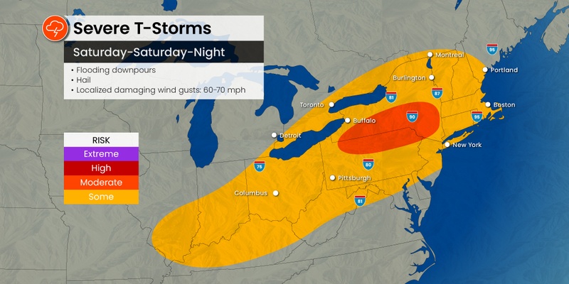
The storms fired up on Friday night across the Midwest and the Southeast, starting the weekend off with a bang for a number of major cities. Saturday will not be much better for outdoor plans for a large swath of the country with over 70 million people at risk of experiencing severe weather. The arrival of a cool front will bring the impacts to parts of the Ohio Valley and the Northeast.
There are two distinct areas that will be the most at risk of storm development on Saturday. An area stretching across northern Pennsylvania and upstate New York will see widespread impacts. A secondary zone will be focused on the southwestern corner of Ohio, southern Indiana, and into the northern tier of Kentucky.
Cities that could see the severe weather develop at various times throughout the day and night include Louisville, Columbus, Pittsburgh, and Buffalo. The fringes of the storm system could creep into major metropolitan areas such as New York City and Boston.
Heavy rain that triggers flash flooding will likely be the biggest concern out of Saturday’s weather maker. This will be particularly true for the parts of the Northeast and New England that have recorded a good amount of rainfall recently.
Stargazers hoping to catch the much-anticipated Perseid meteor shower will likely be disappointed in the viewing conditions in this part of the country. Even if the rain stays away, a thick cloud cover is expected to obscure the viewing opportunities of these shooting stars. With the right weather conditions, you could expect to see up to 100 meteors per hour out of this show.
After a brief respite on Saturday, the chances of severe weather will be back in the forecast for the nation’s heartland on Sunday. A powerful storm system is set to arrive from Canada to close out the weekend, putting over 10 states in the crosshairs of potentially dangerous weather.
The area most likely to see storms erupt on Sunday include much of eastern Kansas and into Missouri and across into Illinois. The impact zone will expand to the north to include all of Iowa, eastern portions of Nebraska and South Dakota, and the southern half of Minnesota.
These storm cells will usher in the usual impacts, including heavy rain, strong winds, and isolated tornadic activity. For this part of the country, Saturday is shaping up to be the better weather day of the weekend.

Sunday’s storm system will continue to move to the east while picking up strength along the way. This could translate to a rocky start to the new work week, just as many kids may be heading back to school for the first time. Forecasters are predicting that the Great Lakes and the Ohio Valley will experience the worst of these impacts on Monday, impacting about 40 million people in Illinois, Tennessee, Ohio, New York, and beyond.
The worst of Monday’s weather event is on tap for a zone stretching from southwestern Pennsylvania and down into the central portions of Kentucky. The activity will ignite when the weather maker brings up the warm and moisture-rich air from the Gulf of Mexico to collide with the cooler air coming from the West. This clash will result in a fair chance of tornadoes across the Ohio Valley.
Flash flooding will also be a concern with Monday’s weather. This risk will be heightened if the system produces storms that train over the region and create repeated downpours. Small stream flooding will be a potential problem across the Ohio Valley because of the expectation of heavy rain.
The weather system will also usher in strong winds throughout the Great Lakes, forming high waves along with the thunderstorms. There is also a risk of waterspouts in the waters of Lake Michigan, Lake Ontario, and Lake Erie because of the turbulence associated with this storm system.
By Tuesday, the major cities of the Northeast may begin to see some of the impacts. Forecasters are still uncertain about the timing and the intensity of the storms by the time that they reach this part of the Eastern Seaboard. A slower movement of the cool front to the east will result in a greater chance of severe weather for the East Coast on Tuesday.
The storms are also expected to expand to the south on Tuesday, bringing travel disruptions to populated areas such as Atlanta, Raleigh, and Charlotte. You will want to stay turned to the forecast as meteorologists fine tune their predictions.
The latter half of August is forecast to bring warmer temperatures and drier conditions as the storm train finally calms down. The heat dome that has been anchored over Texas for weeks will move to the north, encompassing much of the Midwest and beyond. This area of high pressure will allow heat to build across the eastern half of the U.S. As a result, the long-range forecast is calling for temperatures to climb above the historical average for the end of August for many areas of the Northeast and the Midwest.
Did you find this content useful? Feel free to bookmark or to post to your timeline for reference later.

January 21, 2024

January 19, 2024

January 18, 2024