
Heavy Rain, Flooding, and Chance of Severe Weather Staring Down the Southern U.S.
January 22, 2024
Posted: August 18, 2023 8:40 am


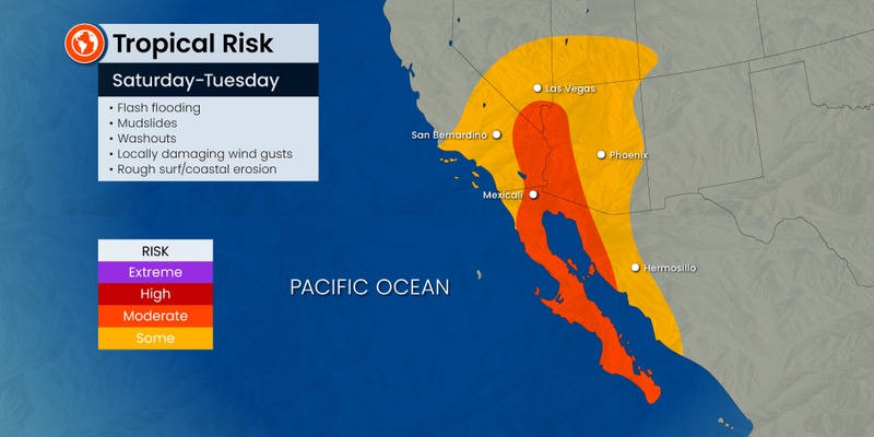
A newly formed tropical storm is threatening to bring flooding rainfall to parts of Arizona, Nevada, and California in the coming days. Here is the latest on this developing situation.
Tropical Storm Hilary formed on Wednesday in the East Pacific, expected to unleash its impacts across the Southwest by the weekend. The threats of flash flooding will linger well into next week due to the amount of moisture associated with this tropical feature.
Hilary came together on Tuesday morning, sporting maximum sustained winds of 40 mph. The feature was located about 500 miles away from the southwestern corner of the Mexican coast when it reached official tropical storm status.
The current models predict that Hilary will intensify into at least a Category 3 hurricane as it churns off the southern tip of the Baja peninsula in Mexico this weekend. A hurricane of this strength brings wind speeds between 111 and 129 mph.
It is not usual for these types of tropical features to impact the Desert Southwest. Typical steering patterns tend to take these storms out to sea and deep into the Pacific before their moisture reaches the U.S. coastline. However, it is also not completely unheard for the impacts to creep this far northward.
Forecasters are predicting that Hilary’s reach may be enough to impact northern Baja California beginning this weekend. The models are still uncertain about where the storm will end up landing should it reach the U.S.
As of Wednesday, the projections show Hilary bringing wind gusts of up to 110 mph to parts of Mexico with rainfall amounts totaling up to 20 inches. Storms that hit the northern half of the Baja California region usually break up quickly due to the rugged terrain of the region. But forecasters caution that the impacts from this particular storm could linger well inland and onto U.S. soil.

The potential impacts to the Southwest will become more clear in the coming days. However, forecasters warn that this part of the U.S. could see localized flash flooding, severe thunderstorms, isolated tornadoes, and damaging winds.
The heavy rain will move into the U.S. at least a few days before Hilary’s eye potentially moves on shore. Cities that could see the significant moisture accompanying this tropical event include San Diego, Los Angeles, Phoenix, and Las Vegas.
Southern California is forecast to see the rain move in by Saturday. The moisture will also impact southern portions of Nevada and into central Arizona by the start of the weekend. In addition to torrential rain, this weather maker will likely bring the risk of mudslides in the hilly terrains.
Travel could be impacted because of the heavy rain. Hikers heading out to the canyons in the region will want to practice extreme caution and stay abreast of any developing situation. It will not take much rain for the dry canyons to quickly fill with water and present dangerous conditions for outdoor enthusiasts.
This part of the Southwest can expect to see a general 1 – 2 inches of rain. This is more than enough to trigger flooding conditions across the dry terrain. Normally arid locations such as Death Valley National Park and Palm Springs in California will be at risk of seeing flooding rainfall.
It was just last summer that a round of severe weather washed out the roads across National Valley National Park, leaving over 1,000 park goers stranded. Experts are warning that Hilary may bring this same level of impact to the desert region.
Air travel could also be severely disrupted due to the numerous thunderstorms expected to accompany Hilary as it pushes inland.
While Hilary has the potential of causing widespread disruptions across the Southwest, there is also the chance that the cooler ocean waters located off of the coast of northern Mexico will cause the storm to lose intensity. How quickly the storm weakens is what forecasters will be closely monitoring in the coming days.
There is still the chance that a storm moving at the speed of Hilary may not linger over these cooler waters for enough time to lose its strength. Should this happen, the feature could make landfall across the northern part of Mexico, meaning that its impacts would be felt throughout the southwestern corner of the U.S.
Even if Hilary weakens considerably, its far-reaching impacts may be felt well beyond the Southwest. The moisture coming along for the ride with this storm will continue to move to the north and impact much of the western U.S. heading into next week. This expectation will translate to an increased risk of flash flooding for the Great Basin and into the Rocky Mountains.
The leftover rain from Hilary may make it as far as Northern California. This forecast is all good news for a part of the country that is carefully monitoring the chance of wildfires. While the moisture will dampen the grounds and help to mitigate this risk, the frequent lightning strikes present in most tropical events could ignite new fires.
Did you find this content useful? Feel free to bookmark or to post to your timeline for reference later.

January 21, 2024

January 19, 2024

January 18, 2024
