
Heavy Rain, Flooding, and Chance of Severe Weather Staring Down the Southern U.S.
January 22, 2024
Posted: September 19, 2022 12:58 pm


Fiona Forecast to Move Over Bermuda and Potentially Hit Atlantic Canada
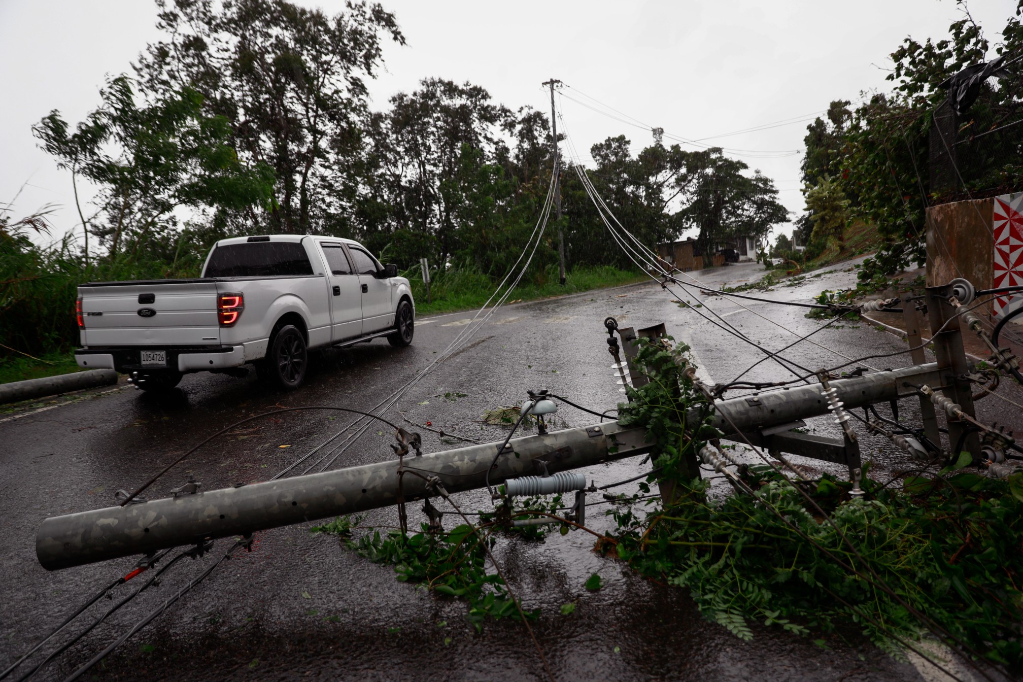
Five years after Hurricane Maria created mass destruction across Puerto Rico, the island is now dealing with the massive impacts of Hurricane Fiona. The storm hit the southwest corner of the U.S. territory on Sunday, unleashing significant flooding, triggering mudslides, and knocking out power to the entire island.

Hurricane Fiona made landfall as a Category 1 hurricane at 3:20 pm EDT on Sunday near Punta Tocon. The storm was packing maximum sustained winds of 85 mph when it roared onshore. Fiona went on to make another landfall in the Dominican Republic early Monday morning.
The entirety of the island of Puerto Rico lost power after the storm moved across the area. By Monday morning, only a small number of the 1.4 million customers across the island had their power restored. Officials are warning that it could take days to restore power to the island. The good news is that the power is back for the network of hospitals in the capital city of San Juan.
The storm inundated the island with almost 30 inches of rain, creating massive flooding and submerging cars and rushing into homes. An airport runway in the southern part of the island was completely submerged with brown water.
Although the city of San Juan escaped the worst of the floodwaters, it was a different story along the southern coastal areas and in the countryside.
In addition to the loss of power, over 778,000 residents are also without drinking water as of Monday morning. Officials say that the river levels must recede to a designated level before workers can resume the process of filtering the water.
![[Image of probabilities of 34-kt winds]](https://www.nhc.noaa.gov/storm_graphics/AT07/refresh/AL072022_wind_probs_34_F120+png/150115.png)
The rain is still lingering over some parts of the island, making it likely that certain portions may see rainfall totals eclipse the 30-inch mark by the time the storm has completely moved away. Even a new bridge installed by the National Guard after the destruction of Hurricane Maria could not withstand the rising water and resulting landslide. The bride in Utuado was washed away as the landslide moved through the central mountain town.
While it is still too early to know the full extent of the damage, there is sure to be some infrastructure destruction. The island’s infrastructure was heavily damaged as a result of Category 4 Hurricane Maria in 2017 with many homes still using blue tarps for roof coverings. This weakened infrastructure has made the island more vulnerable to smaller storms such as Fiona.
Rivers are cresting throughout the island, breaking previous records in the process. For instance, the Rio Guanajibo River near Hormigueros crested at 29.2 feet on Monday morning. This broke the past record of 28.6 feet after Hurricane Maria.
U.S. President Joe Biden declared a state of emergency on Sunday morning, freeing up federal resources to help with the response efforts. The declaration clears the way for the Federal Emergency Management Agency (FEMA) to facilitate relief efforts for the U.S. territory.
Residents are being urged to remain indoors. Shelters are open for those seeking refuge from the floodwaters. $550 million in emergency funds is available for officials to draw on in the coming days and weeks.
Approximately 12 hours after Hurricane Fiona moved across Puerto Rico, it journeyed into the Dominican Republic, remaining a Category 1 storm. The storm made landfall at about 3:30 am local time approximately 20 miles to the southwest of Punta Cana.
Forecasters are telling residents of the Dominican Republic to prepare for more life-threatening flooding events and strong winds before the storm finally moves back out into the Caribbean.
Fiona will not be finished after it moves past the Dominican Republic. Meteorologists are predicting that Fiona will move closer to Bermuda by the end of the week. The eyewall of the storm is forecast to pass over portions of the Turks and Caicos Islands as it picks up wind speed and intensifies in the coming days. The current projection shows Fiona strengthening into a Category 3 storm by the middle of the week, boasting maximum wind speeds of 111 – 129 mph.
Should this prediction come to fruition, Fiona will be distinguished as the first Category 3 major hurricane of the 2022 Atlantic season. There is also the chance that Fiona could intensify further into a Category 4 storm as it tracks over the southwest edges of Bermuda.
While the weather pattern could still change, forecasters are expecting that a shot of cold air coming from the Northeast will interact with Fiona later this week. This will cause the storm system to accelerate and make a turn to the northeast, bringing it closer to Bermuda than originally expected.
This path would not only put Bermuda in the impact zone but it would also put Atlantic Canada on alert. Bermuda is forecast to see tropical downpours with an estimated 2 inches of rain on Thursday and Friday. The group of islands will also see strong winds as Fiona accelerates. At the moment, forecasters are predicting gusts up to 120 mph.
Although Fiona is not forecast to make a direct hit on the U.S., it will track close enough to the Eastern Seaboard to churn up the seas and generate dangerous rip currents and surf conditions. The East Coast will experience high waves and minor coastal flooding and beach erosion as the storm tracks to the north hundreds of miles from the coast.
Beachgoers and boaters along the Eastern Seaboard will need to pay close attention to all advisories. This is especially important as most beaches are no longer staffed by lifeguards now that the high summer season is over.
Did you find this content useful? Feel free to bookmark or to post to your timeline for reference later.

January 21, 2024

January 19, 2024

January 18, 2024
