
Heavy Rain, Flooding, and Chance of Severe Weather Staring Down the Southern U.S.
January 22, 2024
Posted: January 15, 2023 10:47 am


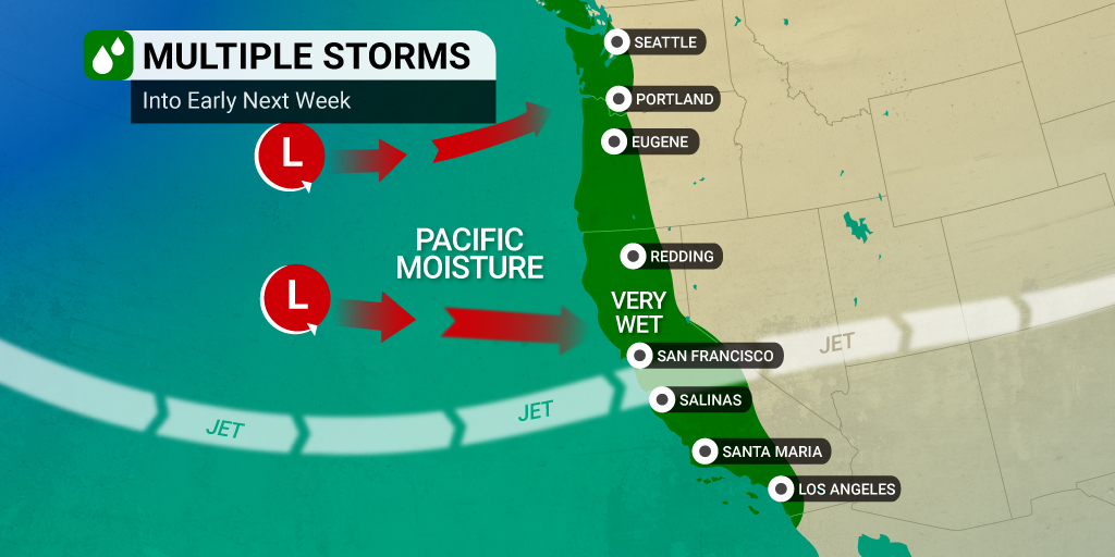
The West Coast will be at risk of more heavy rain and flooding through next week as the train of storms continues to form in the Pacific Ocean and move on shore. The storms will add more moisture to the waterlogged region, putting communities at a greater risk of flooding and mudslides.
Forecasters warn that every additional bout of rain increases the threat of landslides as the grounds become even more saturated. Additionally, winds do not have to be that strong to bring down trees when the grounds are so unstable. Tree roots are already starting to loosen in the ground with topsoil becoming more unstable with every round of precipitation. This movement could lead to widespread power outages.
Winds are forecast to hit between 40 and 60 mph through the early part of next week with some localized stronger gusts. The highest winds will impact the higher terrains of the state.
The Golden State saw a slight respite from the pounding rain and snow on Thursday and Friday, however, the conditions became more unsettled again on Saturday. This rain and snow impacted nearly every part of the state to start the weekend. Despite the rain sticking around to start the work week, meteorologists said that this precipitation will not be the result of a classic atmospheric river.
Instead, the next storm will produce rain that is shorter in duration when compared to the fire hose effect of the last several systems. That said, this next round of storms may still be capable of sending down up to 6 inches of rain in as little as 6 hours.
In addition, the early week storms are also expected to come with a lower snow level than the previous systems. This could translate to travel difficulties over some of the busiest mountain passes across the Sierra Nevada. For instance, motorists planning to travel over Donner Pass on Interstate 5 in California are being advised to check for road closures and other potential difficulties before setting out on their journey.
While it may not seem possible at this point, forecasters are signaling that there may be relief in sight in the coming week. The weather pattern is forecast to shift later next week, bringing more of the moisture northward to the Pacific Northwest and southward into the interior Southwest.
Looking ahead to the end of January, forecasters are predicting that a large area of high pressure will set up over California and up and down the Pacific Coast. This high pressure may avert the arrival of storms firing up in the Pacific Ocean.
However, the active storm track is likely to return to California and beyond by late February and early March.
There is no doubt that this constant barrage of storms has wreaked havoc on everyday life for Californians. The onslaught of storms has done wonders to improve drought conditions, particularly across the Sierra Nevada. Snowpack levels are measuring well above normal for this time of the year thanks to a steady stream of wintry precipitation to start the year.
This snow will eventually melt in the coming months as the temperature rises, filling up empty water reservoirs and flowing into other streams, rivers, and lakes. Some of the state’s most important reservoirs have already seen water levels rise to near normal or even above. For instance, Millerton Reservoir is now at 150% of normal.
Although the Sierra Nevada has been the beneficiary of the storms to start 2023, the long-range forecast shows this weather pattern moving into the Southwest in the coming days. This will bring more moisture to the exceptionally dry Colorado River basin.
Just how wet has it been in California? According to the National Weather Service (NWS), about 24 trillion gallons of water have hit California since the storms first fired up at the end of December. Some parts of Central California are already at half of their annual precipitation totals in the last 16 days alone.
San Francisco has also been hit especially hard with the city measuring more rain in the initial 11 days of the month than what fell during the first 11 months of 2022. Normally drier Southern California has also seen excessive amounts of moisture. For instance, Nordhoff Ridge recorded over 18 inches of rain in 48 hours.
The normally dry Bishop weather station became the first station in the U.S. to hit its average precipitation total for the year when it came in at 4.84 inches by January 11. January 9 is now in the record books as the six-wettest day in history for the city of Bishop.
Some portions of the state’s mountain ranges are also being hammered with snow. Mammoth Mountain reported 72 inches of new snow on Monday and Tuesday to send the ski resort’s total for the season up to 328 inches. This number is more than three times what the resort has seen over the last three winter seasons.
Located approximately 100 miles southeast of Lake Tahoe, the snow was so deep at Mammoth Mountain that the resort was forced to close temporarily.
Overall, the snowpack level across the southern Sierra Nevada was sitting at over 250% of average as of last Wednesday. According to the California Department of Water Resources, the water content of this impressive snowpack is now higher than what is usually seen on April 1, the date considered to be the peak of the snowpack prior to the spring melt off.
Did you find this content useful? Feel free to bookmark or to post to your timeline for reference later.

January 21, 2024

January 19, 2024

January 18, 2024
