
Heavy Rain, Flooding, and Chance of Severe Weather Staring Down the Southern U.S.
January 22, 2024
Posted: January 20, 2022 1:02 pm


Some Areas of East Coast May See Lowest Readings of the Season
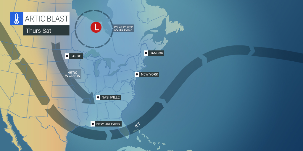
If you are reaching for your heaviest winter coat these days, you are not alone. An invasion of Arctic air is going to stick around for a significant amount of time in the eastern U.S.
The cold air began to move down from Canada early in the week. Central Park in New York City recorded a low of just 10 degrees on January 15 and 16, approximately 20 degrees below average for this time of the year. Also on January 17, the temperature in the nation’s capital plummeted to 17 degrees.
Single digits have been common for much of the interior Northeast. Pittsburgh hit a low of just 6 degrees on January 8 while the mercury in Albany, New York dipped below zero on two different occasions earlier this week.
The cold temperatures have not been limited to the Northeast. Unseasonably cold weather has also been spreading across the South. The city of Atlanta recorded a high temperature of just 41 degrees on January 7, 13 degrees below average for that calendar date. As night fell, the temperature dropped to 28 degrees.
Despite its location right along the shores of the Gulf of Mexico, Biloxi, Mississippi dropped below freezing on January 4, a rarity in this part of the country.
While these cold temperatures in the South were fleeting, this next blast of Arctic air is going to have more staying power. Not only will this weather system bring much colder temperatures to the region, but it will also deliver a chance of snow to some unlikely places.
The overnight low in Atlanta on Saturday night is forecast to drop into the mid-20s. This would be the coldest temperature for the city since last February. The interior parts of Florida will likely see overnight lows in the 30s, sending citrus growers rushing to protect their plants against the impending frost.
The Midwest began seeing the influx of noticeably colder air on Wednesday. The temperature will begin to plunge in the Tennessee Valley and the Northeast on Thursday night. This will happen when the ridge of strong Arctic high pressure will track through the region. Some areas will see some of the coldest temperatures of the winter season out of this air mass.
By Friday, the frigid air will reach the Southeast and the Eastern Seaboard. This influx of colder temperatures will set the stage for the possibility of yet another snow and ice storm for some areas of the South and up through the mid-Atlantic.
Some of the coldest areas of the country on Friday night will be in the interior Southeast and Northeast. By the time the sun rises on Saturday, many areas of the Northeast may be recording temperatures well below zero degrees. This includes a significant area of land stretching from eastern Ohio and western Pennsylvania up through upstate New York and well into the higher terrains of interior New England.
There is a possibility that many of these areas may experience the coldest night in years. For example, Pittsburgh is predicted to drop under zero degrees on Friday night. Should this happen as forecasted, it will be the first time that the mercury dips this low in almost three years.
Farther north in Syracuse, New York, the overnight low for Friday is forecast to drop to 12 degrees below zero, challenging a record set in 2005.
Although the interior Northeast will be privy to the extreme cold, the bulk of the busy Interstate 95 corridor will have the benefit of cloud cover keeping things slightly warmer. Thursday night is expected to be the coldest of the month in cities such as Washington, D.C., Boston, and New York City. For example, the thermometer may plunge to 13 degrees in Central Park, coming close to hitting the lowest reading of the year so far of 10 degrees.
There is a slight temperature rebound in the forecast for the majority of the eastern half of the nation by the end of the weekend and heading into next week. However, forecasters are certain that this cold infusion of air is going to hang around until the end of January. Some places in the interior Northeast may not climb out of the mid-30s for the rest of the month.
In addition, residents of the South will need to be wary of frosts and freezes in the forecast. This includes areas of the Gulf Coast and deep into Florida.

January 21, 2024

January 19, 2024

January 18, 2024
