
Heavy Rain, Flooding, and Chance of Severe Weather Staring Down the Southern U.S.
January 22, 2024
Posted: September 2, 2023 7:20 am


Forecasters with the National Hurricane Center (NHC) have been kept on their toes the past few weeks as the tropical activity in the Atlantic is seeing a significant surge. When will the next storm threaten the U.S.? Here is a look into what is happening in the Atlantic basin these days.
It has been a busy few weeks for the Atlantic with a number of named features taking root. As of late Friday, there were four current or former named storms currently churning through the Atlantic. This list includes Hurricane Idalia, Hurricane Franklin, Tropical Storm Gert, and Tropical Storm Jose. Although Hurricane Idalia dealt a big blow to Florida and the southeastern U.S. earlier in the week, there is no direct threat to the country at this time.
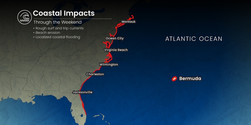
What is left of Hurricane Idalia is expected to inch closer to Bermuda throughout the day. While the island nation will not see a landfall, the outer bands of the weather maker will bring heavy rain, gusty squalls, and rough surf conditions throughout the weekend. Forecasters are also warning that Idalia could re-organize and strengthen back into a tropical storm over the next few days thanks to the warm waters in this part of the basin.
There is also the chance that Idalia could change direction and head to the north. Should this happen, Atlantic Canada could see the impacts of this long-lived storm by the end of next week.
Tropical Storm Gert is another interesting storm to follow. After dying out earlier in the week, the feature sprung back to life and took on tropical storm characteristics once again. However, like Tropical Storm Jose, this feature is forecast to dissipate again shortly.
What was once Hurricane Franklin has also been roaming the Atlantic for quite some time after coming to life on August 20. This feature is forecast to remain a tropical storm until early next week.
Although these tropical weather events will not bring direct impacts to the U.S., the swells generated by storms could potentially impact the East Coast beaches with high waves, strong rip currents, and rough surf conditions. Be sure to pay heed to any warnings if your Labor Day plans take you to the coast this weekend. It is also prudent to only swim in areas with a lifeguard on duty.
Forecasters are closely monitoring a new system that has emerged from the west coast of Africa, warning that it could take on tropical characteristics and drift toward the Caribbean and the U.S. over the next several days. This tropical wave will take several days to cross the vast expanse of the Atlantic.
The Cabo Verde Islands will likely see the first impacts of this system. However, there is also a chance that this tropical wave could break apart before it gets going due to a number of inhibiting factors. Should it remain intact through early next week, it is forecast to find more favorable conditions for development. The NHC has confirmed that this part of the eastern Atlantic Ocean is registering exceptionally warm water temperatures and low amounts of wind shear, both factors needed to support tropical weather development and intensification.
This tropical wave would take the name Lee if it develops into a named storm, assuming that Katia has already been taken. While it is still too early to forecast, there is a chance that the feature could move into the Caribbean Sea and drift close to the U.S. by the middle of September.
In addition, another broad area of showers and thunderstorms has now been designated as Tropical Depression 12. Should this system develop into a tropical storm, it will be named Katia. This feature is forecast to move to the north over the open waters of the west-central Atlantic, avoiding any major land mass.
Did you find this content useful? Feel free to bookmark or to post to your timeline for reference later.

January 21, 2024

January 19, 2024

January 18, 2024
