
Heavy Rain, Flooding, and Chance of Severe Weather Staring Down the Southern U.S.
January 22, 2024
Posted: August 31, 2023 9:45 am


What was once a Category 4 hurricane may not be going away soon. The remnants of Idalia could spin around in the Atlantic and make an appearance in or near Bermuda just as the island nation is dealing with the aftermath of Hurricane Franklin. Here is the latest on the situation in the tropics as the 2023 Atlantic hurricane season heats up.
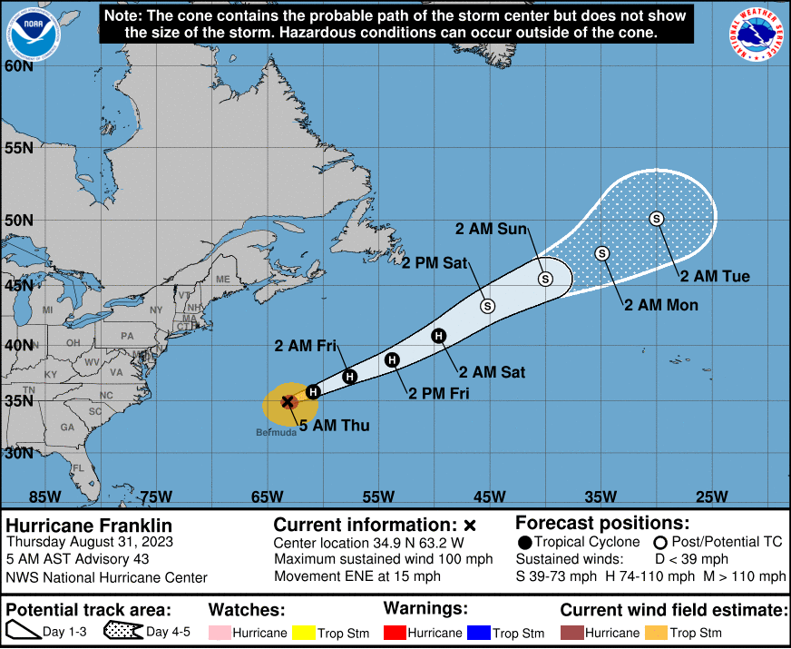
Hurricane Franklin has been wreaking havoc across the Caribbean for over a week. After making a landfall in the Dominican Republic a few days ago, the storm skirted past the island of Bermuda before moving out into the open waters of the Atlantic. By late Wednesday, the storm was a Category 2 storm packing maximum sustained winds of 105 mph.
This designation was a downgrade from its peak strength of a Category 4 storm earlier in the week. Franklin was distinguished as the first major hurricane of the 2023 Atlantic season. A major hurricane is defined as a storm that reaches Category 3 strength or higher. With the formation of Idalia, the 2023 season has now seen two major hurricanes as it inches closer to the statistical peak date of September 10.
Because it did not take a direct strike from Franklin, Bermuda is experiencing impacts that are similar to a tropical storm. A tropical storm warning was in effect for the nation throughout Wednesday as the storm brought in strong winds, moderate rainfall, and rough surf conditions.
The current models indicate that Franklin will be nudged to the north into the northern portions of the Atlantic Ocean beginning on Thursday. A separate non-tropical system positioned over this region of the basin will pull the moisture left from Franklin to the north, bringing the chance of substantial rain to Atlantic Canada.
Meteorologists will be watching the future path of Idalia as it tears across the southeastern corner of the U.S. and moves out to sea. The latest forecast calls for what is left of Idalia to stall out through the end of the week before moving to the northeast early next week.
As the storm wanders in the open waters of the central Atlantic, it could bring more rain to Bermuda beginning on Friday and lasting through the weekend. The islands could see 1 – 2 inches of rain during this time period. However, forecasters warn that this amount of rain could increase if Idalia decides to stall out again in this part of the Atlantic. As such, it will be important for interests in and around Bermuda to closely monitor the movements of what is left of Idalia.
Idalia is predicted to maintain its tropical-storm-force winds as it meanders through the Atlantic to start the month of September. The location of Idalia in relation to Bermuda will influence the magnitude of winds that hit the group of islands. Current predictions estimate that gusts of 40 to 60 mph are a good possibility. These gusts could be strong enough to bring down vulnerable trees and toss around light outdoor furniture.
This is traditionally the time of the year in which the tropics begin to come alive with more frequent bouts of activity. In addition to the formation of hurricanes Idalia and Franklin over the past week, Tropical Depression 11 also formed hundreds of miles from Bermuda on Tuesday morning. The National Hurricane Center (NHC) said that this feature poses no threat to any land as it is expected to move to the north over the open waters of the central Atlantic before breaking apart.
There is a medium chance of tropical development in the eastern portion of the Atlantic basin near the Cabo Verde Islands. This development is forecast to move to the north-northwest into the central Atlantic. The Cabo Verde Islands will take the brunt of this tropical depression with gusty winds and locally heavy rain showers and thunderstorms through at least Thursday.
Lastly, another area near Tropical Depression 11 could take on tropical characteristics on Thursday. However, any development will be short-lived for this feature and the current environmental conditions will lead to its weakening before it has any chance to impact land.
Did you find this content useful? Feel free to bookmark or to post to your timeline for reference later.

January 21, 2024

January 19, 2024

January 18, 2024
