
Heavy Rain, Flooding, and Chance of Severe Weather Staring Down the Southern U.S.
January 22, 2024
Posted: September 8, 2022 12:54 pm


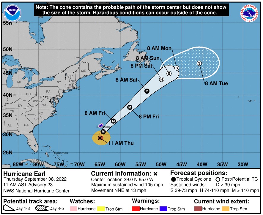
Hurricane Earl is picking up in size and intensity as it churns near Bermuda, putting the group of islands under a hurricane watch as the storm nears Category 3 status. Here is the latest update on what is happening in the tropics.
As a Category 2 storm, Hurricane Earl is now distinguished as the strongest tropical cyclone in the Atlantic Basin so far this year. The National Hurricane Center (NHC) predicts that the storm will continue to strengthen in the coming hours. Earl is forecast to max out as a Category 4 storm that may deliver impacts to the East Coast of the U.S.
Hurricane Earl was spinning about 250 miles south of Bermuda as of Thursday morning. The storm is moving to the north at a speed of 10 mph, picking up a bit of speed from Wednesday’s movement. Earl is producing sustained winds of 105 mph as it continues to grow. The hurricane-force winds are now extending at least 60 miles out from the eye of the storm with the tropical-storm-force winds stretching 160 miles from the center.
The islands of Bermuda are now under a tropical storm warning and a hurricane watch with experts predicting that the region will begin to see the impacts of Earl late Thursday and into Friday morning. Officials in Bermuda have already posted warning signs along the beaches alerting people of high surf conditions.
The eye of the storm is forecast to skirt to the east of Bermuda in the overnight hours Thursday into Friday. The absence of strong wind shear in the area will allow Earl to intensify further by this time.
Bermuda can expect to see rough surf conditions, strong winds, and rain. The worst of the winds and rain will pass to the east of the islands. Bermuda itself should be ready for gusts up to 60 mph and a general 1-2 inches of rain. Flooding should be limited to poor drainage areas.
While Hurricane Earl is not forecast to make a direct strike on the U.S., the sheer size and intensity of this monster storm will translate to impacts to the East Coast. Earl is currently predicted to pass over 800 miles east of North Carolina. Hurricane experts warn that storms this big can produce significant swells over 1,000 miles from the storm. This will trigger rough surf conditions and dangerous rip currents over the next few days.
![[Image of probabilities of 34-kt winds]](https://www.nhc.noaa.gov/storm_graphics/AT06/refresh/AL062022_wind_probs_34_F120+png/150131.png)
The National Weather Service (NWS) is also warning that the Outer Banks of North Carolina will be in the impact zone for coastal flooding. Minor coastal flooding is a strong possibility in areas such as Nags Head and Rodanthe.
Shipping interests in this part of the Atlantic also need to take note of the potential impacts of Earl.
In addition to Hurricane Earl, the NHC is closely monitoring a number of tropical waves developing off the coast of Africa. Experts are predicting that these waves will pick up in frequency over the next few weeks.
One particular disturbance of note is moving approximately 1,000 miles west-northwest of the Cabo Verde Islands. Hurricane watchers have given this disturbance a high chance of turning into the next named storm. The next name on the predetermined list is Fiona.
While the last few features have headed to the north and avoided impacts with the U.S, the predicted strengthening of the Bermuda high will push future systems to the west. This track gives the storms a higher chance of moving into the Caribbean and toward the U.S. rather than out into the open waters of the Atlantic.
If Earl develops into a major hurricane as expected, defined as a Category 3 or higher, it will happen about one week behind the average date for a storm of this nature.
Did you find this content useful? Feel free to bookmark or to post to your timeline for reference later.

January 21, 2024

January 19, 2024

January 18, 2024
