
Heavy Rain, Flooding, and Chance of Severe Weather Staring Down the Southern U.S.
January 22, 2024
Posted: January 4, 2023 3:46 pm


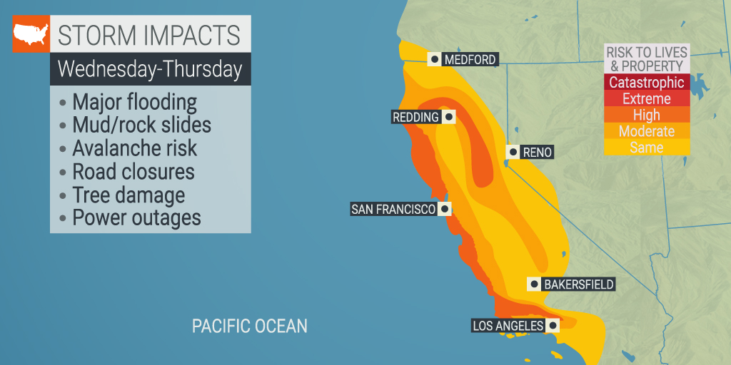
The state of California has barely been able to catch its breath from the rain of the last several days with a new powerful storm bearing down on the region. Forecasters are warning that a rapidly building storm will strengthen into a bomb cyclone off the coast of the Golden State on Wednesday, slamming into the area with destructive winds and life-threatening flooding events. Here is what you need to know as this storm picks up power and heads to the coast.
The heavy rain and snow will be fueled by a massive atmospheric river that got its start in the tropical Pacific Ocean days ago. Known as the Pineapple Express, this type of weather phenomenon originating near Hawaii typically brings heavy rain, strong winds, and snow to the heavy elevations.
Even after the rain moves out, those Californians in the line of fire will be at risk of seeing mudslides and other dangerous weather impacts for several days. In addition, grounds that have already been saturated from the moisture of the last few weeks will also heighten the risk of flooding.
The process of bombogenesis is defined in meteorological terms when the barometric pressure drops by at least 0.71 of an inch in a period of only 24 hours. If a weather feature undergoes this process, it is commonly referred to as a bomb cyclone. Forecasters are calling for the atmospheric river currently moving toward Northern California to undergo the cycle of bombogenesis, resulting in the bomb cyclone by Wednesday.
The bomb cyclone is predicted to reach the coast of Central California by late Wednesday with Southern California seeing the impacts by early Thursday. With a storm of this magnitude, it is not unusual for rainfall amounts to hit over 2 inches per hour. This is particularly true when the rain comes down over the higher elevations.
When it comes to total rainfall, the heaviest hit areas may see 4 – 8 inches of rain out of this system. This is in addition to the torrential rain that came down in the same area over the weekend.
As a result of the impending heavy rain, the California Department of Water Resources said that it is ready with flood fight tools and equipment spread out at 38 locations in the state. In addition, the organization has sent out levee inspectors to be ready prior to the worst of the rain.
The region most likely to see over 4 inches of rain from this particular system are the coastal areas of the state located to the north and south of the Bay Area. The mountains located north of Los Angeles may also see rain of this magnitude. Lastly, the west-facing slopes of the Sierra Nevada east of the capital city of Sacramento are also expected to see a significant amount of rain.
The major metropolitan areas of San Francisco, Los Angeles, and Sacramento will be at risk of flash flooding as the rain pummels the region. San Francisco is forecast to see 2 – 4 inches of new rain accumulation with up to 3 inches falling in Sacramento and Los Angeles. What is most concerning is that the bulk of the rain is predicted to fall within a 12-hour period, creating greater flooding concerns as the water quickly collects on roadways.
Motorists are being advised to be extra careful about washed-out roads and other hazards. For instance, the strong winds expected with this system will be powerful enough to uproot vulnerable trees and bring down power lines. The winds may approach hurricane-force level magnitude, translating to 74 mph or more. This is not uncommon for bomb cyclones as the winds whip up as the barometric pressure tumbles.
It is not too late to prepare for the storm by stocking up on gas to run generators and non-perishable foods. It is also a good idea to fill your vehicle with gas if you have time before conditions begin to deteriorate in your area.
Although the snow levels will start off above pass level on Wednesday, these levels will start to come down late in the evening and into Thursday. You can expect snowfall measured in feet in elevations above 7,000 feet.
Travel across some of the passes in the Sierra Nevada may become impossible late Wednesday and early Thursday as the snow piles up and the winds send visibility down to near zero. Similar to the events of New Year’s weekend, some stretches of Interstate 80 may also be forced to close if the snow becomes heavy enough.
The mountain passes in Southern California should remain viable throughout the storm as snow levels are forecast to remain above the major roadways. However, Siskiyou Summit across Interstate 5 at the state’s border with Oregon could see dicey travel because of the snow.
Nobody is blaming Californians for wishing the rain away. It has been an especially wet few weeks for this corner of the country. The atmospheric river that hit the northern and central portions of the state on New Year’s Eve led to the second-highest daily rainfall ever recorded for downtown San Francisco when the city hit 5.46 inches.
It was not just heavy rain that was falling to close out 2022. The Central Sierra Snow Lab recorded an hourly snowfall rate of 7.5 inches per hour across Saturday afternoon.
While it has no doubt been a mess to deal with, the moisture is a great help for a state dealing with long-term drought concerns. Weather experts are predicting even more storms in the coming weeks as the Pacific Ocean remains active with new developments. Not only will these storms bring beneficial rain, but they will also usher in significant snowfall to help with the region’s snowpack.
The storm track is forecast to move farther to the north by the end of the month, bringing the moisture to Oregon and Washington.
Did you find this content useful? Feel free to bookmark or to post to your timeline for reference later.

January 21, 2024

January 19, 2024

January 18, 2024
